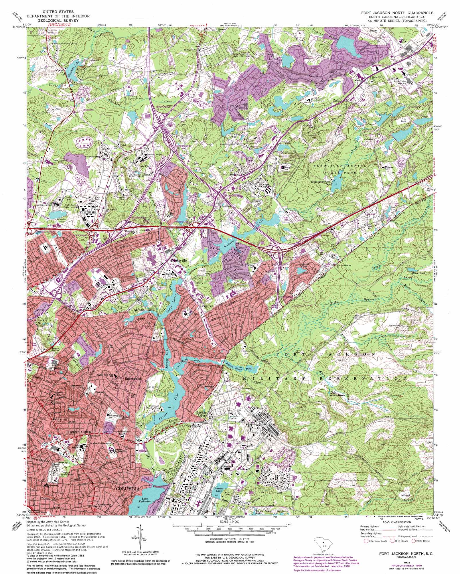
Fort Jackson North Topo Map South Carolina
To zoom in, hover over the map of Fort Jackson North
USGS Topo Quad 34080a8 - 1:24,000 scale
| Topo Map Name: | Fort Jackson North |
| USGS Topo Quad ID: | 34080a8 |
| Print Size: | ca. 21 1/4" wide x 27" high |
| Southeast Coordinates: | 34° N latitude / 80.875° W longitude |
| Map Center Coordinates: | 34.0625° N latitude / 80.9375° W longitude |
| U.S. State: | SC |
| Filename: | o34080a8.jpg |
| Download Map JPG Image: | Fort Jackson North topo map 1:24,000 scale |
| Map Type: | Topographic |
| Topo Series: | 7.5´ |
| Map Scale: | 1:24,000 |
| Source of Map Images: | United States Geological Survey (USGS) |
| Alternate Map Versions: |
Fort Jackson North SC 1953, updated 1957 Download PDF Buy paper map Fort Jackson North SC 1953, updated 1968 Download PDF Buy paper map Fort Jackson North SC 1972, updated 1974 Download PDF Buy paper map Fort Jackson North SC 1972, updated 1990 Download PDF Buy paper map Fort Jackson North SC 2011 Download PDF Buy paper map Fort Jackson North SC 2014 Download PDF Buy paper map |
1:24,000 Topo Quads surrounding Fort Jackson North
Rion |
Winnsboro Mills |
Ridgeway |
Longtown |
Rabon Crossroads |
Richtex |
Irmo Ne |
Blythewood |
Elgin |
Lugoff |
Irmo |
Columbia North |
Fort Jackson North |
Messers Pond |
Leesburg |
Lexington |
Southwest Columbia |
Fort Jackson South |
Congaree |
Eastover |
Pelion East |
Gaston |
Saylors Lake |
Gadsden |
Wateree |
> Back to 34080a1 at 1:100,000 scale
> Back to 34080a1 at 1:250,000 scale
> Back to U.S. Topo Maps home
Fort Jackson North topo map: Gazetteer
Fort Jackson North: Crossings
Interchange 15 elevation 79m 259′Interchange 16 elevation 91m 298′
Interchange 17 elevation 93m 305′
Interchange 18 elevation 97m 318′
Interchange 19 elevation 102m 334′
Interchange 71 elevation 84m 275′
Interchange 72 elevation 113m 370′
Interchange 73 elevation 92m 301′
Interchange 74 elevation 82m 269′
Interchange 76 elevation 97m 318′
Fort Jackson North: Dams
Arcadia Woods Lake Dam elevation 67m 219′Boyden Arbor Dam - Fort Jackson elevation 59m 193′
Burnside Lake Dam elevation 80m 262′
Clarks Lake D-0563 Dam elevation 109m 357′
Coopers Pond Dam elevation 66m 216′
Entrance Lake Dam elevation 96m 314′
Forest Lake Dam elevation 51m 167′
Lake Katherine Dam elevation 44m 144′
Moores Pond D-0555 Dam elevation 86m 282′
Pine Springs Dam Number One D-0560 elevation 90m 295′
Pine Springs Dam Number Two D-0561 elevation 96m 314′
Pine Springs Lake D-0559 Dam elevation 90m 295′
Pine Springs Pond D-0562 Dam elevation 107m 351′
Semmes Lake Dam - Fort Jackson elevation 65m 213′
Simpson Pond Dam D-3651 elevation 79m 259′
South Carolina Noname 40002 Dam elevation 68m 223′
South Carolina Noname 40005 Dam elevation 84m 275′
South Carolina Noname 40013 D-0569 Dam elevation 74m 242′
South Carolina Noname 40026 Dam elevation 59m 193′
South Carolina Noname 40027 Dam elevation 85m 278′
South Carolina Noname 40049 D-0551 Dam elevation 90m 295′
Springwood Lake D-0558 Dam elevation 65m 213′
Upper Windsor Lake D-0570 Dam elevation 65m 213′
Wildewood Pond Five D-0564 Dam elevation 93m 305′
Wildewood Pond One D-0568 Dam elevation 89m 291′
Wildewood Pond Three D-0566 Dam elevation 101m 331′
Wildewood Pond Two D-0567 Dam elevation 96m 314′
Windsor Lake Dam D-0571 elevation 65m 213′
Fort Jackson North: Lakes
Lake in the Woods elevation 72m 236′Sesquicentennial Pond elevation 74m 242′
Fort Jackson North: Parks
Forest Lake Park elevation 83m 272′Hammond Park (historical) elevation 75m 246′
Patton Stadium elevation 73m 239′
Sesquicentennial State Park elevation 74m 242′
Trenholm Park elevation 74m 242′
Fort Jackson North: Populated Places
Arcadia Lakes elevation 69m 226′Boyden Arbor elevation 60m 196′
Brandywine elevation 88m 288′
Briarwood elevation 94m 308′
Brickyard Village elevation 63m 206′
Charleswood elevation 89m 291′
Clear Springs elevation 103m 337′
Deaswood elevation 49m 160′
Dentsville elevation 72m 236′
Drexel Lake Hills elevation 89m 291′
East Lake Hills elevation 73m 239′
Edinburgh elevation 82m 269′
Fairwold elevation 98m 321′
Farrowoods elevation 97m 318′
Folkestone elevation 84m 275′
Forest Acres elevation 75m 246′
Forest Trace elevation 69m 226′
Forestwood Estates elevation 90m 295′
Foxhall elevation 75m 246′
Gregg Park elevation 54m 177′
Hampton Trace elevation 62m 203′
Huntcliff elevation 101m 331′
Huntington elevation 73m 239′
Jiggs elevation 110m 360′
Kilbourne Heights elevation 76m 249′
Kilbourne Park elevation 78m 255′
Lake Elizabeth Estates elevation 80m 262′
Lakeview elevation 58m 190′
North Trenholm elevation 82m 269′
North Washington Park elevation 92m 301′
Old Forest elevation 79m 259′
Ravenwood elevation 67m 219′
Ravinwood elevation 71m 232′
Richland elevation 88m 288′
Rockbridge elevation 89m 291′
Sandwood elevation 88m 288′
Satchel Ford Terrace elevation 78m 255′
Spring Valley elevation 90m 295′
Springhill elevation 75m 246′
Springwood elevation 76m 249′
State Park elevation 109m 357′
State Park Acres elevation 111m 364′
Tanglewood elevation 79m 259′
Weddell elevation 108m 354′
Wedgewood elevation 81m 265′
Wildewood elevation 99m 324′
Williamsburg East elevation 82m 269′
Windsor Estates elevation 84m 275′
Windsor Lake Park elevation 68m 223′
Woodfield elevation 104m 341′
Woodfield Park elevation 78m 255′
Fort Jackson North: Reservoirs
Alcohol and Drug Abuse Lake elevation 96m 314′Boyden Arbor Lake elevation 57m 187′
Boyden Arbor Pond elevation 59m 193′
Boyds Pond One elevation 89m 291′
Boyds Pond Three elevation 101m 331′
Boyds Pond Two elevation 96m 314′
Bruners Pond elevation 74m 242′
Burnside Lake elevation 80m 262′
Carys Lake elevation 84m 275′
Carys Lakes elevation 59m 193′
Clark Pond elevation 74m 242′
Clarks Lake elevation 109m 357′
Coopers Pond elevation 66m 216′
Coopers Pond elevation 67m 219′
Drexel Lake elevation 86m 282′
Entrance Lake elevation 96m 314′
Forest Lake elevation 67m 219′
Forest Lake elevation 51m 167′
Jim Hammond Pond (historical) elevation 60m 196′
Lake Elizabeth elevation 68m 223′
Lake Katherine elevation 44m 144′
Moores Pond elevation 86m 282′
Rockford Lake elevation 56m 183′
Rocky Ford Lake elevation 59m 193′
Semmes Lake elevation 65m 213′
Sesqui elevation 70m 229′
Simpson Pond elevation 79m 259′
Spring Lake elevation 56m 183′
Spring Valley Lake elevation 90m 295′
Springwood Lake elevation 65m 213′
Upper Rocky Ford Lake elevation 85m 278′
Wildewood Pond Number Five elevation 93m 305′
Windsor Lake elevation 65m 213′
Fort Jackson North: Streams
Bynum Creek elevation 65m 213′Cumbess Creek elevation 69m 226′
Dry Branch elevation 74m 242′
Eightmile Branch elevation 49m 160′
Jackson Creek elevation 59m 193′
Lightwood Knot Branch elevation 69m 226′
Lightwood Knot Branch elevation 60m 196′
Little Jackson Creek elevation 60m 196′
Mack Creek elevation 59m 193′
Orphanage Branch elevation 57m 187′
Pen Branch elevation 44m 144′
Rose Creek elevation 71m 232′
Rowell Creek elevation 63m 206′
Fort Jackson North: Summits
Quinine Hill elevation 107m 351′Fort Jackson North digital topo map on disk
Buy this Fort Jackson North topo map showing relief, roads, GPS coordinates and other geographical features, as a high-resolution digital map file on DVD:
South Carolina, Western North Carolina & Northeastern Georgia
Buy digital topo maps: South Carolina, Western North Carolina & Northeastern Georgia