Blythewood Topo Map South Carolina
To zoom in, hover over the map of Blythewood
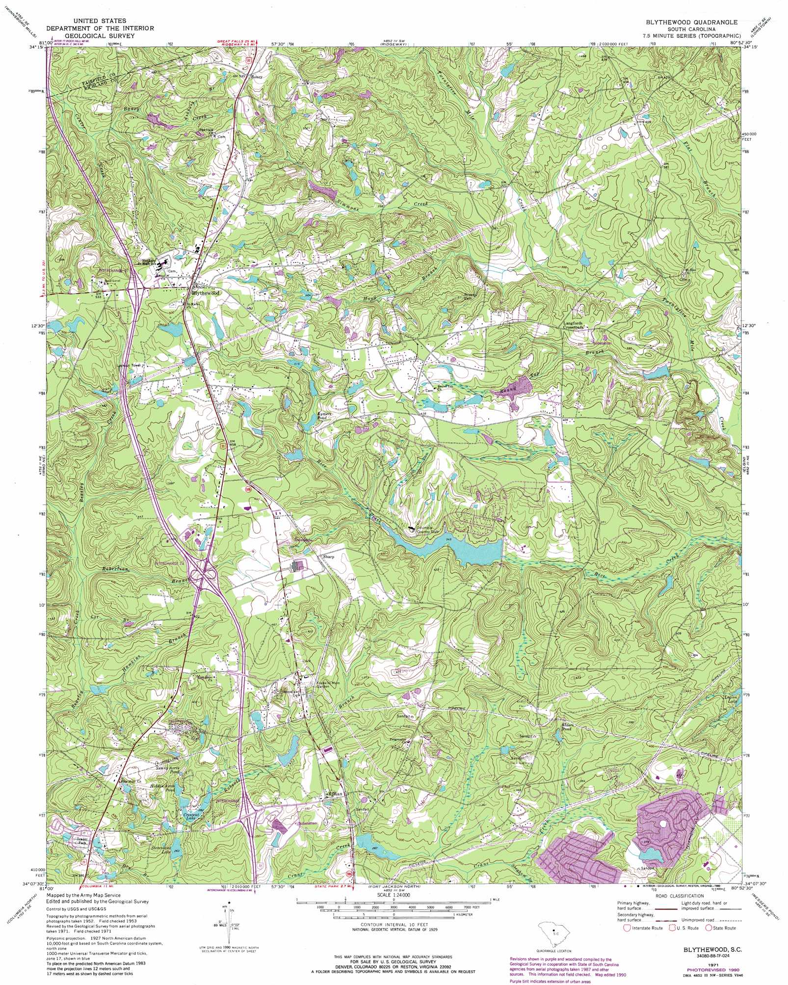
USGS Topo Quad 34080b8 - 1:24,000 scale
| Topo Map Name: | Blythewood |
| USGS Topo Quad ID: | 34080b8 |
| Print Size: | ca. 21 1/4" wide x 27" high |
| Southeast Coordinates: | 34.125° N latitude / 80.875° W longitude |
| Map Center Coordinates: | 34.1875° N latitude / 80.9375° W longitude |
| U.S. State: | SC |
| Filename: | o34080b8.jpg |
| Download Map JPG Image: | Blythewood topo map 1:24,000 scale |
| Map Type: | Topographic |
| Topo Series: | 7.5´ |
| Map Scale: | 1:24,000 |
| Source of Map Images: | United States Geological Survey (USGS) |
| Alternate Map Versions: |
Blythewood SC 1953, updated 1957 Download PDF Buy paper map Blythewood SC 1971, updated 1973 Download PDF Buy paper map Blythewood SC 1971, updated 1990 Download PDF Buy paper map Blythewood SC 2011 Download PDF Buy paper map Blythewood SC 2014 Download PDF Buy paper map |
1:24,000 Topo Quads surrounding Blythewood
Lebanon |
Winnsboro |
Flint Hill |
Liberty Hill |
Whiteoak Creek |
Rion |
Winnsboro Mills |
Ridgeway |
Longtown |
Rabon Crossroads |
Richtex |
Irmo Ne |
Blythewood |
Elgin |
Lugoff |
Irmo |
Columbia North |
Fort Jackson North |
Messers Pond |
Leesburg |
Lexington |
Southwest Columbia |
Fort Jackson South |
Congaree |
Eastover |
> Back to 34080a1 at 1:100,000 scale
> Back to 34080a1 at 1:250,000 scale
> Back to U.S. Topo Maps home
Blythewood topo map: Gazetteer
Blythewood: Crossings
Interchange 22 elevation 114m 374′Interchange 24 elevation 123m 403′
Interchange 27 elevation 162m 531′
Blythewood: Dams
Barnnets Pond D-0392 Dam elevation 121m 396′Clarks Pond D-0411 Dam elevation 103m 337′
Covingtons Lake D-0545 Dam elevation 86m 282′
Epworth Pines D-0362 Dam elevation 94m 308′
Fuller Pond Dam D-1592 elevation 116m 380′
Hospitals Lake D-0413 Dam elevation 95m 311′
Lake Ashley D-1590 Dam elevation 115m 377′
Lake Columbia D-0549 Dam elevation 104m 341′
North Spring Lake D-0550 Dam elevation 111m 364′
Stevensons Lake D-0546 Dam elevation 79m 259′
Blythewood: Lakes
Legion Lake elevation 97m 318′Blythewood: Populated Places
Blythewood elevation 152m 498′Boney elevation 161m 528′
Green Springs elevation 122m 400′
Killian elevation 102m 334′
Langfords Crossroads elevation 109m 357′
North Crossing elevation 136m 446′
North Pines elevation 117m 383′
North Springs elevation 112m 367′
Rose Creek elevation 106m 347′
Sharp elevation 134m 439′
Blythewood: Reservoirs
Barnnets Pond elevation 121m 396′Crescent Lake elevation 86m 282′
Elders Pond elevation 104m 341′
Hidden Acres Pond elevation 89m 291′
Hospitals Lake elevation 95m 311′
Lake Columbia elevation 104m 341′
North Spring Lake elevation 111m 364′
Roberts Pond elevation 95m 311′
Rymers Pond elevation 118m 387′
Stevensons Lake elevation 79m 259′
Sunny Acres Pond elevation 93m 305′
Blythewood: Streams
Ashbury Branch elevation 126m 413′Boney Creek elevation 108m 354′
Hawkins Branch elevation 85m 278′
Hood Branch elevation 89m 291′
Lot Branch elevation 94m 308′
Roberts Branch elevation 87m 285′
Robertson Branch elevation 98m 321′
Round Top Branch elevation 78m 255′
Simmons Creek elevation 106m 347′
Simmons Creek elevation 99m 324′
Sorghum Branch elevation 91m 298′
Blythewood digital topo map on disk
Buy this Blythewood topo map showing relief, roads, GPS coordinates and other geographical features, as a high-resolution digital map file on DVD:
South Carolina, Western North Carolina & Northeastern Georgia
Buy digital topo maps: South Carolina, Western North Carolina & Northeastern Georgia