Hartsville North Topo Map South Carolina
To zoom in, hover over the map of Hartsville North
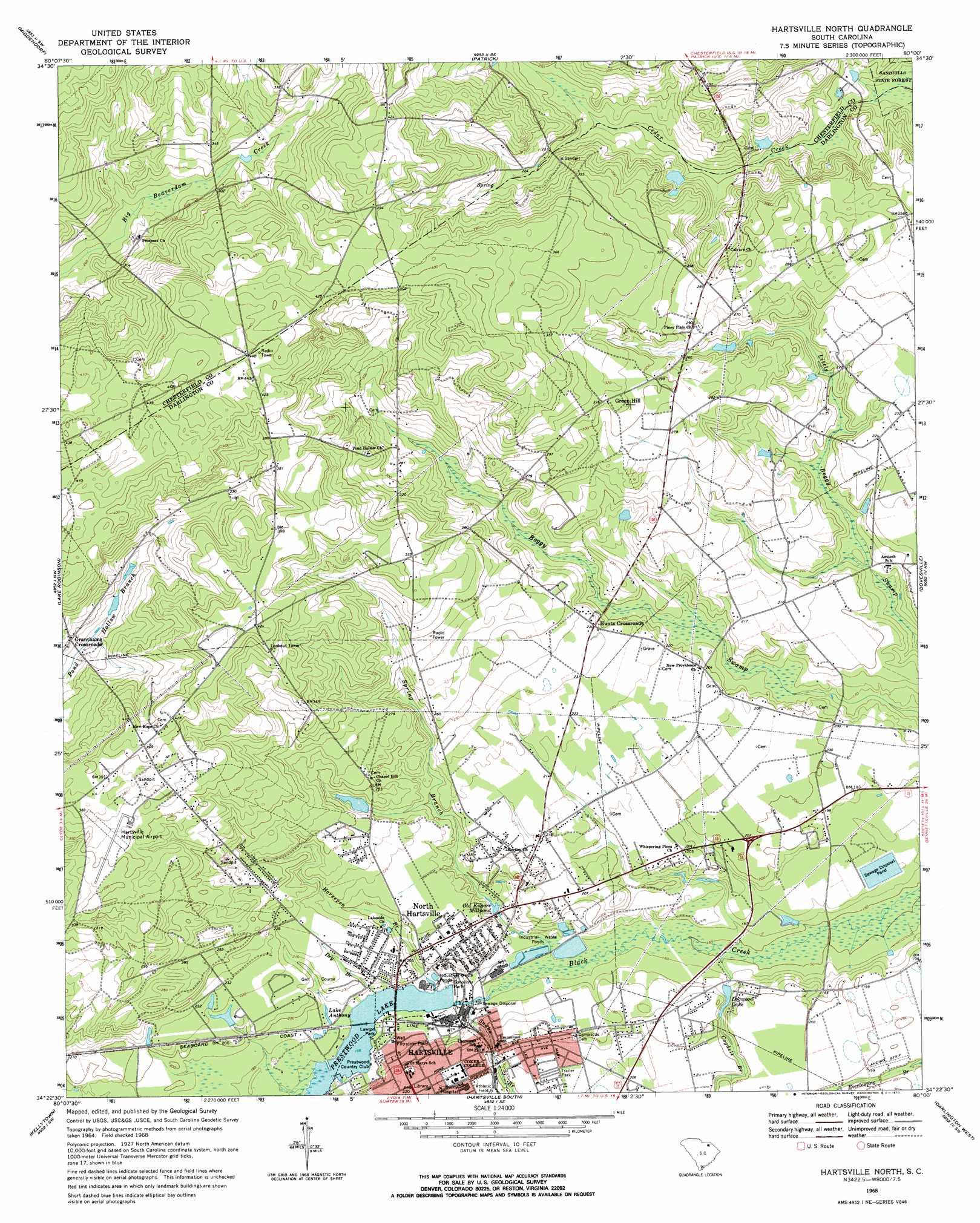
USGS Topo Quad 34080d1 - 1:24,000 scale
| Topo Map Name: | Hartsville North |
| USGS Topo Quad ID: | 34080d1 |
| Print Size: | ca. 21 1/4" wide x 27" high |
| Southeast Coordinates: | 34.375° N latitude / 80° W longitude |
| Map Center Coordinates: | 34.4375° N latitude / 80.0625° W longitude |
| U.S. State: | SC |
| Filename: | o34080d1.jpg |
| Download Map JPG Image: | Hartsville North topo map 1:24,000 scale |
| Map Type: | Topographic |
| Topo Series: | 7.5´ |
| Map Scale: | 1:24,000 |
| Source of Map Images: | United States Geological Survey (USGS) |
| Alternate Map Versions: |
Hartsville North SC 1968, updated 1970 Download PDF Buy paper map Hartsville North SC 2011 Download PDF Buy paper map Hartsville North SC 2014 Download PDF Buy paper map |
1:24,000 Topo Quads surrounding Hartsville North
Jefferson Ne |
Ruby |
Chesterfield |
Cheraw |
Wallace |
Angelus |
Middendorf |
Patrick |
Cash |
Society Hill |
Bethune |
Lake Robinson |
Hartsville North |
Dovesville |
Mont Clare |
Lucknow |
Kellytown |
Hartsville South |
Darlington West |
Darlington East |
Bishopville West |
Bishopville East |
Lamar |
Timmonsville |
Florence West |
> Back to 34080a1 at 1:100,000 scale
> Back to 34080a1 at 1:250,000 scale
> Back to U.S. Topo Maps home
Hartsville North topo map: Gazetteer
Hartsville North: Airports
Curry Airport elevation 59m 193′Hartsville Municipal Airport elevation 108m 354′
Hartsville North: Dams
Dogwood Lake Dam D-3520 elevation 54m 177′Highland Pond Dam D-3517 elevation 68m 223′
Sonoco Industrial Waste Dam D-3521 elevation 61m 200′
South Carolina Noname 16005 Dam elevation 51m 167′
South Carolina Noname 16030 D-3519 Dam elevation 52m 170′
Hartsville North: Lakes
Lake Anthony elevation 56m 183′Hartsville North: Parks
East Home Avenue Historic District elevation 64m 209′Lawton Park elevation 52m 170′
Sonovista Park elevation 51m 167′
Hartsville North: Populated Places
Belair Estates elevation 63m 206′Club Colony elevation 66m 216′
College Heights elevation 63m 206′
Dogwood Acres elevation 60m 196′
Dunlap Terrace elevation 68m 223′
Fox Hollow elevation 78m 255′
Glendale elevation 75m 246′
Glendale Acres elevation 81m 265′
Granthams Crossroads elevation 88m 288′
Green Hill elevation 95m 311′
Hillcrest elevation 62m 203′
Hollandia Park elevation 81m 265′
Hunts Crossroads elevation 70m 229′
Lakewood elevation 61m 200′
North Hartsville elevation 63m 206′
Northwood elevation 79m 259′
Prestwood Village elevation 63m 206′
Sherwood Forest elevation 63m 206′
Tanglewood elevation 55m 180′
Town and Country Estates elevation 60m 196′
Woodbridge elevation 71m 232′
Hartsville North: Reservoirs
City Sewage Disposal Pond Number One elevation 52m 170′Dogwood Lake elevation 52m 170′
Old Kilgore Millpond elevation 55m 180′
Prestwood Lake elevation 51m 167′
Prestwood Lake elevation 54m 177′
Hartsville North: Streams
Cogdell Branch elevation 45m 147′Dry Branch elevation 54m 177′
Horsepen Branch elevation 52m 170′
Snake Branch elevation 48m 157′
Spring Branch elevation 47m 154′
Hartsville North digital topo map on disk
Buy this Hartsville North topo map showing relief, roads, GPS coordinates and other geographical features, as a high-resolution digital map file on DVD:
South Carolina, Western North Carolina & Northeastern Georgia
Buy digital topo maps: South Carolina, Western North Carolina & Northeastern Georgia