Angelus Topo Map South Carolina
To zoom in, hover over the map of Angelus
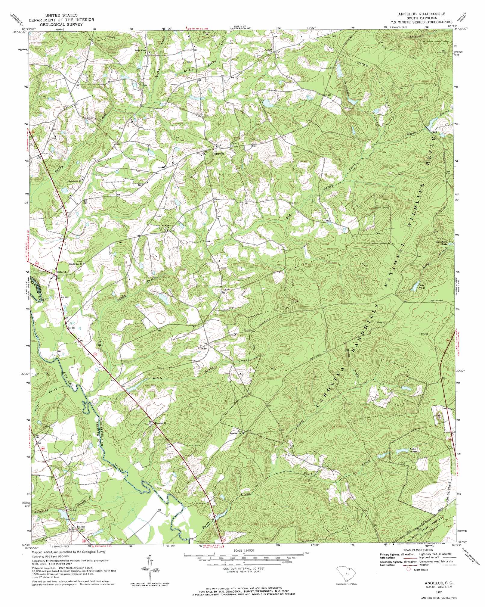
USGS Topo Quad 34080e3 - 1:24,000 scale
| Topo Map Name: | Angelus |
| USGS Topo Quad ID: | 34080e3 |
| Print Size: | ca. 21 1/4" wide x 27" high |
| Southeast Coordinates: | 34.5° N latitude / 80.25° W longitude |
| Map Center Coordinates: | 34.5625° N latitude / 80.3125° W longitude |
| U.S. State: | SC |
| Filename: | o34080e3.jpg |
| Download Map JPG Image: | Angelus topo map 1:24,000 scale |
| Map Type: | Topographic |
| Topo Series: | 7.5´ |
| Map Scale: | 1:24,000 |
| Source of Map Images: | United States Geological Survey (USGS) |
| Alternate Map Versions: |
Angelus SC 1967, updated 1969 Download PDF Buy paper map Angelus SC 2011 Download PDF Buy paper map Angelus SC 2014 Download PDF Buy paper map |
1:24,000 Topo Quads surrounding Angelus
Tradesville |
Pageland |
Hornsboro |
Mount Croghan |
Morven West |
Taxahaw |
Jefferson |
Jefferson Ne |
Ruby |
Chesterfield |
Kershaw |
Mount Pisgah |
Angelus |
Middendorf |
Patrick |
Westville |
Bethune Nw |
Bethune |
Lake Robinson |
Hartsville North |
Camden North |
Cassatt |
Lucknow |
Kellytown |
Hartsville South |
> Back to 34080e1 at 1:100,000 scale
> Back to 34080a1 at 1:250,000 scale
> Back to U.S. Topo Maps home
Angelus topo map: Gazetteer
Angelus: Crossings
Evans Ford elevation 76m 249′Angelus: Dams
Herb Leard Pond Dam D-3181 elevation 98m 321′Kirkleys Small Pond Dam D-3238 elevation 101m 331′
Kirley Pond Dam D-1812 elevation 85m 278′
South Carolina Noname 13036 D-3227 Dam elevation 92m 301′
South Carolina Noname 28009 D-2513 Dam elevation 80m 262′
Angelus: Lakes
Hamburg Lake elevation 105m 344′Lake James elevation 110m 360′
Angelus: Populated Places
Angelus elevation 125m 410′Catarrh elevation 89m 291′
Junction (historical) elevation 141m 462′
Angelus: Reservoirs
Hortons Pond elevation 80m 262′Kirkleys Pond elevation 92m 301′
Lake Number Seventeen elevation 120m 393′
Angelus: Streams
Big Sandy Creek elevation 73m 239′Buffalo Creek elevation 73m 239′
Jumping Gully elevation 70m 229′
Little Rocky Creek elevation 97m 318′
Little Sandy Creek elevation 73m 239′
North Prong Swift Creek elevation 78m 255′
Oxpen Branch elevation 100m 328′
Rocky Prong elevation 90m 295′
Sevenmile Branch elevation 102m 334′
South Prong Swift Creek elevation 78m 255′
Swift Creek elevation 70m 229′
Angelus digital topo map on disk
Buy this Angelus topo map showing relief, roads, GPS coordinates and other geographical features, as a high-resolution digital map file on DVD:
South Carolina, Western North Carolina & Northeastern Georgia
Buy digital topo maps: South Carolina, Western North Carolina & Northeastern Georgia