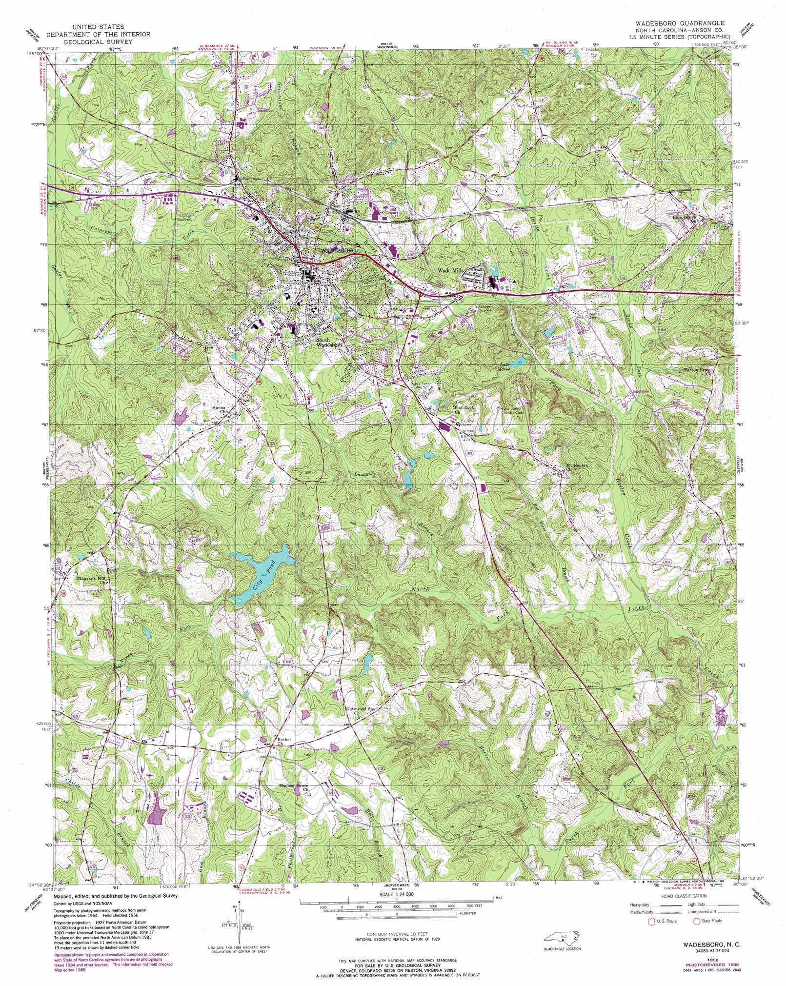
Wadesboro Topo Map North Carolina
To zoom in, hover over the map of Wadesboro
USGS Topo Quad 34080h1 - 1:24,000 scale
| Topo Map Name: | Wadesboro |
| USGS Topo Quad ID: | 34080h1 |
| Print Size: | ca. 21 1/4" wide x 27" high |
| Southeast Coordinates: | 34.875° N latitude / 80° W longitude |
| Map Center Coordinates: | 34.9375° N latitude / 80.0625° W longitude |
| U.S. State: | NC |
| Filename: | o34080h1.jpg |
| Download Map JPG Image: | Wadesboro topo map 1:24,000 scale |
| Map Type: | Topographic |
| Topo Series: | 7.5´ |
| Map Scale: | 1:24,000 |
| Source of Map Images: | United States Geological Survey (USGS) |
| Alternate Map Versions: |
Wadesboro NC 1956, updated 1957 Download PDF Buy paper map Wadesboro NC 1956, updated 1957 Download PDF Buy paper map Wadesboro NC 1956, updated 1988 Download PDF Buy paper map Wadesboro NC 2002, updated 2003 Download PDF Buy paper map Wadesboro NC 2010 Download PDF Buy paper map Wadesboro NC 2013 Download PDF Buy paper map Wadesboro NC 2016 Download PDF Buy paper map |
1:24,000 Topo Quads surrounding Wadesboro
Oakboro |
Aquadale |
Mount Gilead West |
Mount Gilead East |
Harrisville |
Olive Branch |
Polkton |
Ansonville |
Mangum |
Ellerbe |
Marshville |
Russellville |
Wadesboro |
Lilesville |
Rockingham |
Hornsboro |
Mount Croghan |
Morven West |
Morven East |
Diggs |
Jefferson Ne |
Ruby |
Chesterfield |
Cheraw |
Wallace |
> Back to 34080e1 at 1:100,000 scale
> Back to 34080a1 at 1:250,000 scale
> Back to U.S. Topo Maps home
Wadesboro topo map: Gazetteer
Wadesboro: Airports
Piedmont Medical Center Heliport elevation 117m 383′Wadesboro: Dams
City Pond Dam elevation 98m 321′Lake Maree Dam elevation 95m 311′
Moore Lake Dam elevation 106m 347′
Nelson Lake Dam elevation 121m 396′
Wadesboro: Populated Places
Paris (historical) elevation 83m 272′South Wadesboro elevation 142m 465′
Wade Mills elevation 115m 377′
Wadesboro elevation 156m 511′
Wadesboro: Reservoirs
City Pond elevation 100m 328′Lake Maree elevation 95m 311′
Lake Mdree elevation 96m 314′
Moore Lake elevation 106m 347′
Nelson Lake elevation 121m 396′
Wadesboro Municipal Lake elevation 98m 321′
Wadesboro: Streams
Bailey Creek elevation 76m 249′Brush Fork elevation 86m 282′
Culpepper Creek elevation 85m 278′
Derita Creek elevation 93m 305′
Lampley Branch elevation 85m 278′
Morris Branch elevation 76m 249′
North Fork Jones Creek elevation 67m 219′
Red River Branch elevation 79m 259′
Reedy Fork elevation 85m 278′
South Fork Jones Creek elevation 66m 216′
Wadesboro digital topo map on disk
Buy this Wadesboro topo map showing relief, roads, GPS coordinates and other geographical features, as a high-resolution digital map file on DVD:
South Carolina, Western North Carolina & Northeastern Georgia
Buy digital topo maps: South Carolina, Western North Carolina & Northeastern Georgia