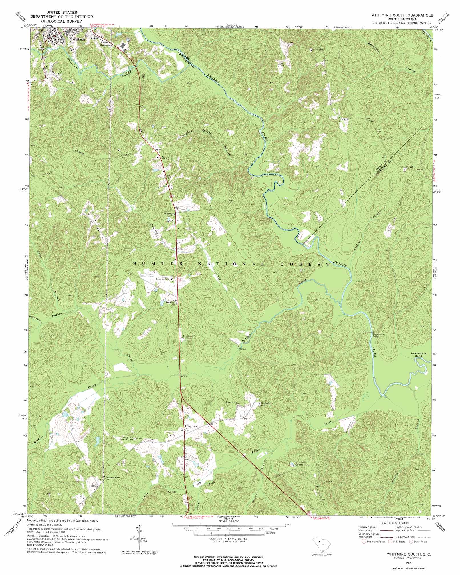
Whitmire South Topo Map South Carolina
To zoom in, hover over the map of Whitmire South
USGS Topo Quad 34081d5 - 1:24,000 scale
| Topo Map Name: | Whitmire South |
| USGS Topo Quad ID: | 34081d5 |
| Print Size: | ca. 21 1/4" wide x 27" high |
| Southeast Coordinates: | 34.375° N latitude / 81.5° W longitude |
| Map Center Coordinates: | 34.4375° N latitude / 81.5625° W longitude |
| U.S. State: | SC |
| Filename: | o34081d5.jpg |
| Download Map JPG Image: | Whitmire South topo map 1:24,000 scale |
| Map Type: | Topographic |
| Topo Series: | 7.5´ |
| Map Scale: | 1:24,000 |
| Source of Map Images: | United States Geological Survey (USGS) |
| Alternate Map Versions: |
Whitmire South SC 1969, updated 1972 Download PDF Buy paper map Whitmire South SC 2011 Download PDF Buy paper map Whitmire South SC 2014 Download PDF Buy paper map |
| FStopo: | US Forest Service topo Whitmire South is available: Download FStopo PDF Download FStopo TIF |
1:24,000 Topo Quads surrounding Whitmire South
Cross Anchor |
Union West |
Union East |
Leeds |
Baton Rouge |
Philson Crossroads |
Sedalia |
Whitmire North |
Carlisle |
Carlisle Se |
Joanna |
Newberry Nw |
Whitmire South |
Blair |
Salem Crossroads |
Bush River |
Newberry West |
Newberry East |
Pomaria |
Jenkinsville |
Chappells |
Silverstreet |
Prosperity |
Little Mountain |
Chapin |
> Back to 34081a1 at 1:100,000 scale
> Back to 34080a1 at 1:250,000 scale
> Back to U.S. Topo Maps home
Whitmire South topo map: Gazetteer
Whitmire South: Bends
Horseshoe Bend elevation 85m 278′Whitmire South: Bridges
Brazzlemans Bridge elevation 86m 282′Whitmire South: Crossings
Avery Ford elevation 88m 288′Whitmire South: Parks
Mollys Rock Recreation Area elevation 113m 370′Whitmire South: Streams
Asias Branch elevation 100m 328′Collins Branch elevation 87m 285′
Duncan Creek elevation 93m 305′
Fosters Branch elevation 85m 278′
Gilders Creek elevation 97m 318′
Hunting Creek elevation 90m 295′
Indian Creek elevation 86m 282′
Kings Creek elevation 85m 278′
Little Kings Creek elevation 99m 324′
Means Branch elevation 94m 308′
Pattersons Creek elevation 102m 334′
South Fork Kings Creek elevation 99m 324′
Sulphur Spring Branch elevation 89m 291′
Wilsons Creek elevation 90m 295′
Whitmire South digital topo map on disk
Buy this Whitmire South topo map showing relief, roads, GPS coordinates and other geographical features, as a high-resolution digital map file on DVD:
South Carolina, Western North Carolina & Northeastern Georgia
Buy digital topo maps: South Carolina, Western North Carolina & Northeastern Georgia