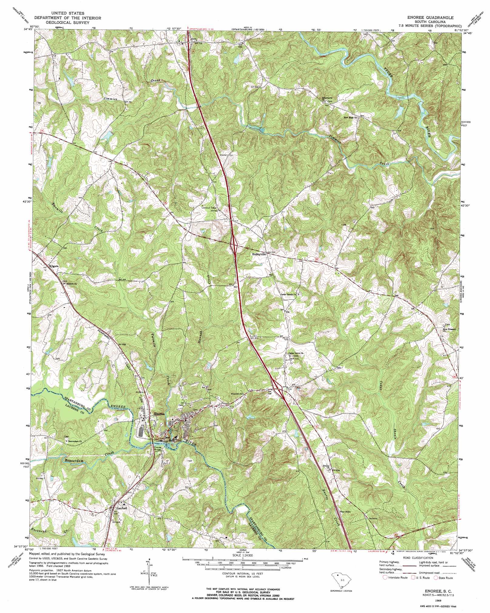
Enoree Topo Map South Carolina
To zoom in, hover over the map of Enoree
USGS Topo Quad 34081f8 - 1:24,000 scale
| Topo Map Name: | Enoree |
| USGS Topo Quad ID: | 34081f8 |
| Print Size: | ca. 21 1/4" wide x 27" high |
| Southeast Coordinates: | 34.625° N latitude / 81.875° W longitude |
| Map Center Coordinates: | 34.6875° N latitude / 81.9375° W longitude |
| U.S. State: | SC |
| Filename: | o34081f8.jpg |
| Download Map JPG Image: | Enoree topo map 1:24,000 scale |
| Map Type: | Topographic |
| Topo Series: | 7.5´ |
| Map Scale: | 1:24,000 |
| Source of Map Images: | United States Geological Survey (USGS) |
| Alternate Map Versions: |
Enoree SC 1969, updated 1973 Download PDF Buy paper map Enoree SC 2011 Download PDF Buy paper map Enoree SC 2014 Download PDF Buy paper map |
1:24,000 Topo Quads surrounding Enoree
Greer |
Wellford |
Spartanburg |
Pacolet |
Pacolet Mills |
Pelham |
Reidville |
Moore |
Glenn Springs |
Jonesville |
Fountain Inn |
Woodruff |
Enoree |
Cross Anchor |
Union West |
Hickory Tavern |
Laurens North |
Ora |
Philson Crossroads |
Sedalia |
Ware Shoals East |
Laurens South |
Clinton |
Joanna |
Newberry Nw |
> Back to 34081e1 at 1:100,000 scale
> Back to 34080a1 at 1:250,000 scale
> Back to U.S. Topo Maps home
Enoree topo map: Gazetteer
Enoree: Airports
Southern Aero Sports Airport elevation 186m 610′Enoree: Bends
Horseshoe Bend elevation 133m 436′Enoree: Bridges
Enoree Bridge elevation 155m 508′Hills Bridge elevation 141m 462′
Ligons Bridge elevation 155m 508′
Enoree: Crossings
Interchange 35 elevation 213m 698′Interchange 38 elevation 211m 692′
Interchange 41 elevation 217m 711′
Enoree: Dams
Hedden Pond Dam D-2981 elevation 174m 570′South Carolina Noname 30012 Dam elevation 197m 646′
T B Pierce Pond Dam D-3389 elevation 157m 515′
W H Tiller Junior Pond Dam D-3388 elevation 178m 583′
W Hudson Pond Dam D-3387 elevation 197m 646′
Enoree: Populated Places
Crows (historical) elevation 217m 711′Enoree elevation 178m 583′
Evinsville elevation 211m 692′
Hillsville elevation 186m 610′
Hobbyville elevation 221m 725′
Kilgore elevation 212m 695′
Lanford elevation 186m 610′
Waldrop Crossroads elevation 216m 708′
Enoree: Rapids
Mountain Shoal elevation 150m 492′Enoree: Reservoirs
Hedden Pond elevation 174m 570′Enoree: Streams
Aiken Branch elevation 164m 538′Beaverdam Creek elevation 155m 508′
Buckhead Creek elevation 139m 456′
Hannah Creek elevation 152m 498′
Harrelson Branch elevation 145m 475′
Twomile Creek elevation 143m 469′
Vise Branch elevation 150m 492′
Wofford Branch elevation 166m 544′
Enoree digital topo map on disk
Buy this Enoree topo map showing relief, roads, GPS coordinates and other geographical features, as a high-resolution digital map file on DVD:
South Carolina, Western North Carolina & Northeastern Georgia
Buy digital topo maps: South Carolina, Western North Carolina & Northeastern Georgia