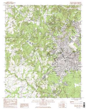
Rock Hill West Topo Map South Carolina
To zoom in, hover over the map of Rock Hill West
USGS Topo Quad 34081h1 - 1:24,000 scale
| Topo Map Name: | Rock Hill West |
| USGS Topo Quad ID: | 34081h1 |
| Print Size: | ca. 21 1/4" wide x 27" high |
| Southeast Coordinates: | 34.875° N latitude / 81° W longitude |
| Map Center Coordinates: | 34.9375° N latitude / 81.0625° W longitude |
| U.S. State: | SC |
| Filename: | o34081h1.jpg |
| Download Map JPG Image: | Rock Hill West topo map 1:24,000 scale |
| Map Type: | Topographic |
| Topo Series: | 7.5´ |
| Map Scale: | 1:24,000 |
| Source of Map Images: | United States Geological Survey (USGS) |
| Alternate Map Versions: |
Rock Hill West SC 1984, updated 1985 Download PDF Buy paper map Rock Hill West SC 1984, updated 1985 Download PDF Buy paper map Rock Hill West SC 2011 Download PDF Buy paper map Rock Hill West SC 2014 Download PDF Buy paper map |
1:24,000 Topo Quads surrounding Rock Hill West
> Back to 34081e1 at 1:100,000 scale
> Back to 34080a1 at 1:250,000 scale
> Back to U.S. Topo Maps home
Rock Hill West topo map: Gazetteer
Rock Hill West: Airports
Bryant Field elevation 199m 652′Country Squire Airport elevation 177m 580′
Rock Hill West: Dams
South Carolina Noname 46014 D-3671 Dam elevation 169m 554′South Carolina Noname 46027 D-3670 Dam elevation 195m 639′
Spencer Pond Dam D-3669 elevation 194m 636′
Rock Hill West: Mines
Rock Hill Quarry elevation 166m 544′Rock Hill West: Parks
Arcade Park elevation 182m 597′Armory Park elevation 192m 629′
Carroll Park elevation 177m 580′
Cedarcrest Park elevation 202m 662′
Cherry Park elevation 199m 652′
Confederate Park elevation 196m 643′
Emmett Scott Park elevation 186m 610′
Fewell Park elevation 189m 620′
Friedman Park elevation 188m 616′
Glencairn Garden elevation 188m 616′
Grove Park elevation 207m 679′
Lige Street Park elevation 186m 610′
Northside Park elevation 185m 606′
Oakwood Acres Park elevation 187m 613′
Rock Hill Downtown Historic District elevation 206m 675′
Spencer Park elevation 193m 633′
Stadium Park elevation 196m 643′
Sullivan Park elevation 188m 616′
Winthrop College Historic District elevation 202m 662′
Winthrop Park elevation 197m 646′
Rock Hill West: Populated Places
Avondale Terrace elevation 184m 603′Beaty Estates elevation 201m 659′
Belair Acres elevation 194m 636′
Belle Meade elevation 181m 593′
Botany Woods elevation 204m 669′
Boyd Hill elevation 195m 639′
Brookwood elevation 186m 610′
Camelot Woods elevation 169m 554′
Cato Estates elevation 192m 629′
Cedar Forest Acres elevation 199m 652′
Cedar Grove Park elevation 189m 620′
Church Hill Heights elevation 211m 692′
Clinton Park elevation 178m 583′
Clubside Estates elevation 183m 600′
College Farms elevation 168m 551′
Country Club Estates elevation 174m 570′
Country Oaks elevation 204m 669′
Coventry Estates elevation 203m 666′
Devonshire elevation 189m 620′
Ebenezer elevation 209m 685′
Fairlawn elevation 198m 649′
Flint Hill elevation 178m 583′
Forest Hills elevation 174m 570′
Glenwood Acres elevation 177m 580′
Greenfield Acres elevation 194m 636′
Heatherwood elevation 197m 646′
Kenilworth Acres elevation 193m 633′
Kimberly Woods elevation 190m 623′
Lakeview Acres elevation 193m 633′
Laney Terrace elevation 187m 613′
Matthews Estates elevation 193m 633′
Meadow Lakes elevation 193m 633′
Mexico elevation 189m 620′
Miller Crossing elevation 215m 705′
Monterey Hills elevation 188m 616′
Newport elevation 213m 698′
Oakdale elevation 195m 639′
Oakdale Acres elevation 192m 629′
Oakwood Acres elevation 177m 580′
Old Farm elevation 200m 656′
Old Point Station elevation 210m 688′
Oldwoods elevation 197m 646′
Pineridge elevation 183m 600′
Quail Run elevation 188m 616′
Quiet Acres elevation 192m 629′
Ragin Estates elevation 190m 623′
Rawlinson Acres elevation 201m 659′
Rawlinson Woods elevation 201m 659′
Red Oaks elevation 186m 610′
Rock Hill elevation 207m 679′
Sedgefield elevation 204m 669′
Shadowbrook elevation 186m 610′
Shiland Hills elevation 186m 610′
Southland Park elevation 174m 570′
Squire Estates elevation 167m 547′
Steele Crossing elevation 174m 570′
Stoneybrook Estates elevation 185m 606′
Sunset Acres elevation 177m 580′
Swan Meadows elevation 189m 620′
Trexler Acres elevation 190m 623′
Westerwood Acres elevation 188m 616′
Whispering Hills elevation 167m 547′
Willow Acres elevation 198m 649′
Wintercrest elevation 201m 659′
Winthrop Heights elevation 201m 659′
Wood Forest elevation 203m 666′
Woodbridge elevation 188m 616′
Woodwind elevation 214m 702′
Rock Hill West: Post Offices
Rock Hill Post Office elevation 199m 652′Rock Hill West: Reservoirs
Mirror Lake elevation 204m 669′Willis Pond elevation 203m 666′
Rock Hill West: Streams
Little Dutchman Creek elevation 157m 515′Tools Fork elevation 161m 528′
Wildcat Creek elevation 156m 511′
Rock Hill West digital topo map on disk
Buy this Rock Hill West topo map showing relief, roads, GPS coordinates and other geographical features, as a high-resolution digital map file on DVD:
South Carolina, Western North Carolina & Northeastern Georgia
Buy digital topo maps: South Carolina, Western North Carolina & Northeastern Georgia


