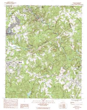
Pacolet Topo Map South Carolina
To zoom in, hover over the map of Pacolet
USGS Topo Quad 34081h7 - 1:24,000 scale
| Topo Map Name: | Pacolet |
| USGS Topo Quad ID: | 34081h7 |
| Print Size: | ca. 21 1/4" wide x 27" high |
| Southeast Coordinates: | 34.875° N latitude / 81.75° W longitude |
| Map Center Coordinates: | 34.9375° N latitude / 81.8125° W longitude |
| U.S. State: | SC |
| Filename: | o34081h7.jpg |
| Download Map JPG Image: | Pacolet topo map 1:24,000 scale |
| Map Type: | Topographic |
| Topo Series: | 7.5´ |
| Map Scale: | 1:24,000 |
| Source of Map Images: | United States Geological Survey (USGS) |
| Alternate Map Versions: |
Pacolet SC 1983, updated 1983 Download PDF Buy paper map Pacolet SC 1983, updated 1992 Download PDF Buy paper map Pacolet SC 2011 Download PDF Buy paper map Pacolet SC 2014 Download PDF Buy paper map |
1:24,000 Topo Quads surrounding Pacolet
> Back to 34081e1 at 1:100,000 scale
> Back to 34080a1 at 1:250,000 scale
> Back to U.S. Topo Maps home
Pacolet topo map: Gazetteer
Pacolet: Dams
C P Pressley Pond Dam D-3382 elevation 207m 679′Calhoun Lake Dam Number Two D-3365 elevation 205m 672′
Calhoun Lakes Incorporated Number One Dam D-3364 elevation 216m 708′
Clifton Mill Number One Pond Dam D-3371 elevation 195m 639′
Clifton Mill Number Three Pond Dam D-3369 elevation 195m 639′
Clifton Mill Pond Number Two Dam D-3372 elevation 164m 538′
Diamond D Pond Dam D-3376 elevation 211m 692′
H Deal Pond Dam D-3370 elevation 221m 725′
J W Crocker Pond Dam D-3373 elevation 213m 698′
Lake Saranac Dam D-3359 elevation 235m 770′
Lithium Corporation Pond Dam D-2785 elevation 224m 734′
Milliken Pond Number Six Dam D-3380 elevation 226m 741′
South Carolina Noname 11024 D-3424 Dam elevation 181m 593′
South Carolina Noname 42010 D-3360 Dam elevation 215m 705′
South Carolina Noname 42012 D-3363 Dam elevation 202m 662′
Sparten Grain Pond Dam D-3381 elevation 215m 705′
Whitestone Number One Pond Dam D-2783 elevation 211m 692′
Whitestone Number Two Pond Dam D-2784 elevation 211m 692′
Pacolet: Mines
Keystone Quarry elevation 217m 711′M and R Quarry elevation 192m 629′
Pacolet Quarry elevation 178m 583′
Pacolet: Parks
Croft State Park elevation 174m 570′Pacolet: Populated Places
Bentway Park elevation 216m 708′Calhoun Lake elevation 226m 741′
Calico elevation 240m 787′
Camp Croft elevation 215m 705′
Cherry Hill elevation 206m 675′
Cinder Creek elevation 230m 754′
Clifton elevation 184m 603′
Clifton Station elevation 234m 767′
Converse elevation 213m 698′
Country Club Estates elevation 203m 666′
Cypress Creek elevation 245m 803′
Delmar Estates elevation 218m 715′
Dunagin elevation 230m 754′
Glendale elevation 207m 679′
Huntington Hills elevation 216m 708′
Lake Forest elevation 228m 748′
Maryville elevation 199m 652′
Oak Creek elevation 217m 711′
Pacolet elevation 238m 780′
Pierce Acres elevation 216m 708′
Ponderosa Gardens elevation 217m 711′
Quail Hollow elevation 212m 695′
Rosewood elevation 226m 741′
Southern Pines elevation 209m 685′
Spring Lake elevation 227m 744′
Sundance elevation 235m 770′
White Stone elevation 237m 777′
Williamsburg Estates elevation 210m 688′
Zion Hill elevation 242m 793′
Pacolet: Post Offices
Clifton Post Office elevation 186m 610′Converse Post Office elevation 212m 695′
White Stone Post Office elevation 237m 777′
Pacolet: Rapids
Big Shoals elevation 180m 590′Pacolet: Reservoirs
C P Pressley Pond elevation 207m 679′Calhoun Lake Number One elevation 216m 708′
Calhoun Lake Number Two elevation 205m 672′
Clifton Mill Number One Pond elevation 195m 639′
Clifton Mill Number Three Pond elevation 195m 639′
Clifton Mill Number Two Pond elevation 164m 538′
Forest Lake elevation 215m 705′
Grain Pond elevation 215m 705′
H Deal Pond elevation 221m 725′
J W Crocker Pond elevation 213m 698′
Lake Johnson elevation 184m 603′
Lake Saranac elevation 235m 770′
Lithium Corporation Pond elevation 224m 734′
Pierce Acres Lake elevation 202m 662′
Whitestone Number One Pond elevation 211m 692′
Whitestone Number Two Pond elevation 211m 692′
Pacolet: Streams
Cinder Branch elevation 192m 629′Fourmile Branch elevation 186m 610′
Halfway Branch elevation 191m 626′
Isoms Creek elevation 186m 610′
Lawsons Fork Creek elevation 160m 524′
Mill Branch elevation 158m 518′
Mineral Spring Branch elevation 201m 659′
Peters Creek elevation 200m 656′
Quinn Branch elevation 162m 531′
Richland Creek elevation 155m 508′
Turkey Hen Branch elevation 163m 534′
Pacolet: Summits
Hayes Hill elevation 225m 738′Pacolet digital topo map on disk
Buy this Pacolet topo map showing relief, roads, GPS coordinates and other geographical features, as a high-resolution digital map file on DVD:
South Carolina, Western North Carolina & Northeastern Georgia
Buy digital topo maps: South Carolina, Western North Carolina & Northeastern Georgia


