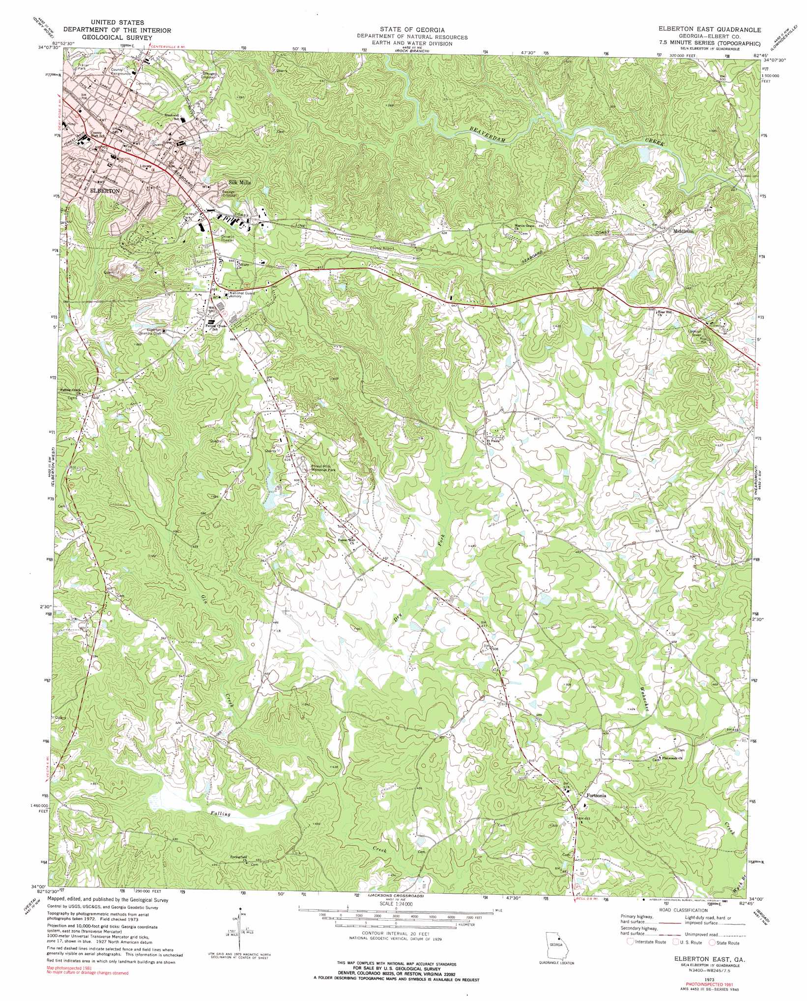
Elberton East Topo Map Georgia
To zoom in, hover over the map of Elberton East
USGS Topo Quad 34082a7 - 1:24,000 scale
| Topo Map Name: | Elberton East |
| USGS Topo Quad ID: | 34082a7 |
| Print Size: | ca. 21 1/4" wide x 27" high |
| Southeast Coordinates: | 34° N latitude / 82.75° W longitude |
| Map Center Coordinates: | 34.0625° N latitude / 82.8125° W longitude |
| U.S. State: | GA |
| Filename: | o34082a7.jpg |
| Download Map JPG Image: | Elberton East topo map 1:24,000 scale |
| Map Type: | Topographic |
| Topo Series: | 7.5´ |
| Map Scale: | 1:24,000 |
| Source of Map Images: | United States Geological Survey (USGS) |
| Alternate Map Versions: |
Elberton East GA 1973, updated 1975 Download PDF Buy paper map Elberton East GA 1973, updated 1991 Download PDF Buy paper map Elberton East GA 2011 Download PDF Buy paper map Elberton East GA 2014 Download PDF Buy paper map |
1:24,000 Topo Quads surrounding Elberton East
Royston |
Hartwell |
Hartwell Dam |
Iva |
Antreville |
Bowman |
Dewy Rose |
Rock Branch |
Lowndesville |
Latimer |
Carlton |
Elberton West |
Elberton East |
Heardmont |
Calhoun Falls |
Sandy Cross |
Vesta |
Jacksons Crossroads |
Broad |
Chennault |
Lexington |
Rayle |
Celeste |
Tignall |
Metasville |
> Back to 34082a1 at 1:100,000 scale
> Back to 34082a1 at 1:250,000 scale
> Back to U.S. Topo Maps home
Elberton East topo map: Gazetteer
Elberton East: Airports
Elbert County Airport-Patz Field elevation 180m 590′Elberton East: Dams
Oglesby North Lake Dam elevation 174m 570′Tate Lake Dam elevation 145m 475′
Elberton East: Parks
Corra Harris Monument elevation 189m 620′Elberton Commercial Historic District elevation 214m 702′
Elberton Residential Historic District elevation 203m 666′
Granite Bowl Stadium elevation 195m 639′
Elberton East: Populated Places
Cauthen elevation 153m 501′Elberton elevation 213m 698′
Fortsonia elevation 153m 501′
Middleton elevation 159m 521′
Silk Mills elevation 206m 675′
Elberton East: Post Offices
Elberton Post Office elevation 213m 698′Elberton East: Reservoirs
Oglesby North Lake elevation 174m 570′Tate Lake elevation 145m 475′
Elberton East: Springs
Lithia Spring elevation 167m 547′Elberton East: Streams
Dry Fork elevation 122m 400′Gin Creek elevation 122m 400′
Wych Branch elevation 117m 383′
Elberton East digital topo map on disk
Buy this Elberton East topo map showing relief, roads, GPS coordinates and other geographical features, as a high-resolution digital map file on DVD:
South Carolina, Western North Carolina & Northeastern Georgia
Buy digital topo maps: South Carolina, Western North Carolina & Northeastern Georgia