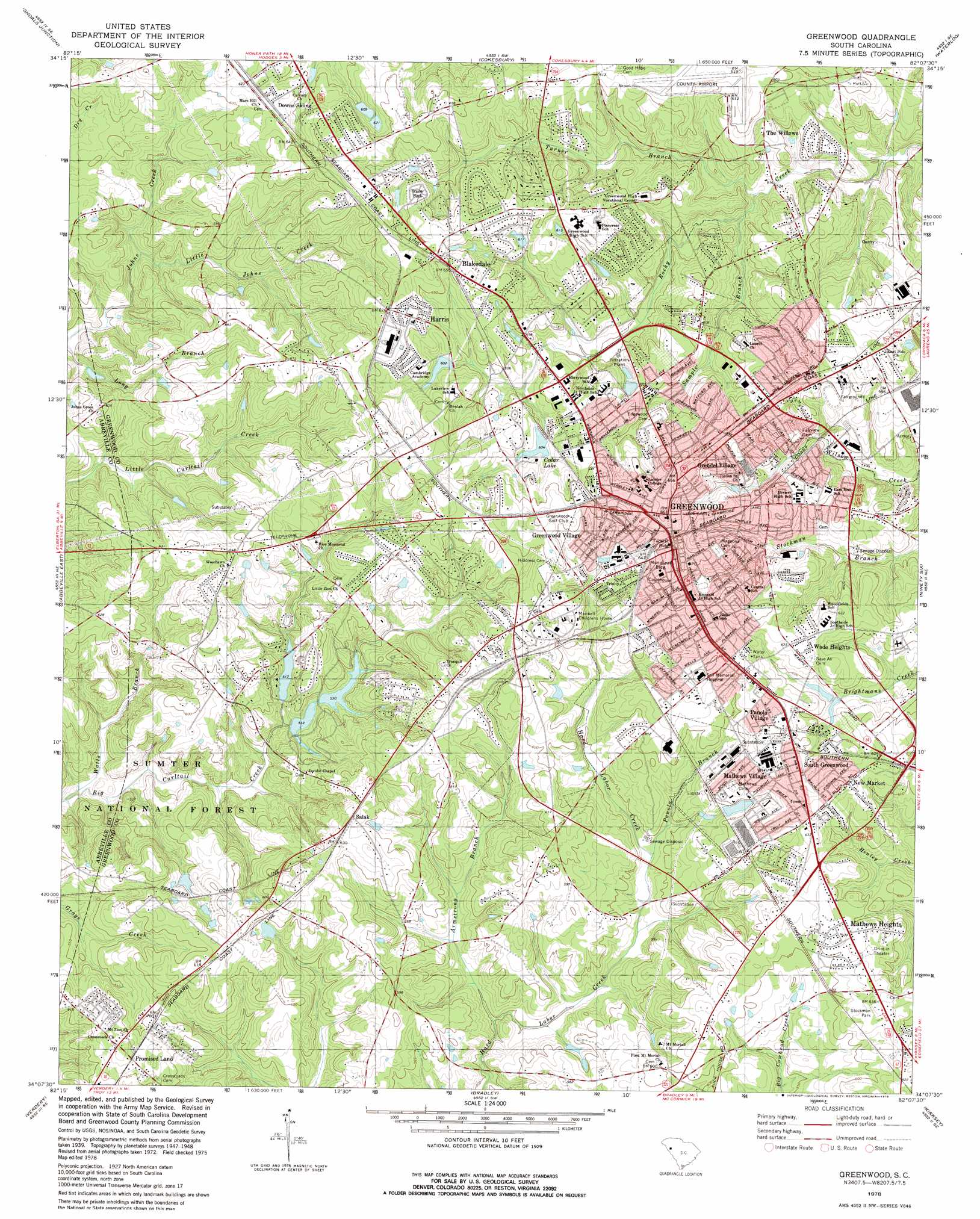
Greenwood Topo Map South Carolina
To zoom in, hover over the map of Greenwood
USGS Topo Quad 34082b2 - 1:24,000 scale
| Topo Map Name: | Greenwood |
| USGS Topo Quad ID: | 34082b2 |
| Print Size: | ca. 21 1/4" wide x 27" high |
| Southeast Coordinates: | 34.125° N latitude / 82.125° W longitude |
| Map Center Coordinates: | 34.1875° N latitude / 82.1875° W longitude |
| U.S. State: | SC |
| Filename: | o34082b2.jpg |
| Download Map JPG Image: | Greenwood topo map 1:24,000 scale |
| Map Type: | Topographic |
| Topo Series: | 7.5´ |
| Map Scale: | 1:24,000 |
| Source of Map Images: | United States Geological Survey (USGS) |
| Alternate Map Versions: |
Greenwood SC 1949 Download PDF Buy paper map Greenwood SC 1978, updated 1979 Download PDF Buy paper map Greenwood SC 2011 Download PDF Buy paper map Greenwood SC 2014 Download PDF Buy paper map |
| FStopo: | US Forest Service topo Greenwood is available: Download FStopo PDF Download FStopo TIF |
1:24,000 Topo Quads surrounding Greenwood
Honea Path |
Ware Shoals West |
Ware Shoals East |
Laurens South |
Clinton |
Due West |
Shoals Junction |
Cokesbury |
Waterloo |
Cross Hill |
Abbeville West |
Abbeville East |
Greenwood |
Ninety Six |
Dyson |
Calhoun Creek |
Verdery |
Bradley |
Kirksey |
Good Hope |
Willington |
Mccormick |
Winterseat |
Limestone |
Owdoms |
> Back to 34082a1 at 1:100,000 scale
> Back to 34082a1 at 1:250,000 scale
> Back to U.S. Topo Maps home
Greenwood topo map: Gazetteer
Greenwood: Airports
Greenwood County Airport elevation 189m 620′Greenwood: Dams
South Carolina Noname 24004 D-1260 Dam elevation 166m 544′South Carolina Noname 24012 D-1267 Dam elevation 173m 567′
South Carolina Noname 24014 D-1268 Dam elevation 166m 544′
South Carolina Noname 24018 D-1272 Dam elevation 165m 541′
Greenwood: Parks
Greenwood Recreation Center elevation 193m 633′Stockman Park elevation 189m 620′
Greenwood: Populated Places
Augusta Fields elevation 184m 603′Avondale elevation 183m 600′
Belle Meade elevation 177m 580′
Blakedale elevation 197m 646′
Breckridge elevation 192m 629′
Briarcliff elevation 199m 652′
Brookside elevation 185m 606′
Bullock (historical) elevation 190m 623′
Canterbury elevation 188m 616′
Cedar Lake elevation 191m 626′
Cherokee Hills elevation 181m 593′
Chinquapin elevation 172m 564′
Cothran (historical) elevation 205m 672′
Crestview elevation 172m 564′
Dalewood elevation 189m 620′
Downs Siding elevation 190m 623′
Druid Hills elevation 194m 636′
Edgemere elevation 198m 649′
Ellenwood Acres elevation 183m 600′
Fawn Brook elevation 191m 626′
Forest Hills elevation 188m 616′
Forest Lake elevation 188m 616′
Glendale elevation 173m 567′
Greenwood elevation 202m 662′
Greenwood Village elevation 192m 629′
Grendel Village elevation 199m 652′
Harris elevation 206m 675′
Highland Forest elevation 187m 613′
Hill and Dale elevation 183m 600′
Hyde Park elevation 204m 669′
Idlewood elevation 201m 659′
Kimbrook elevation 196m 643′
Lakewood Heights elevation 200m 656′
Locksley Hall elevation 190m 623′
Lodge Grounds elevation 197m 646′
Lorenzo (historical) elevation 178m 583′
Mathews Heights elevation 186m 610′
Mathews Village elevation 189m 620′
McCombs elevation 180m 590′
New Market elevation 197m 646′
Northfall Acres elevation 192m 629′
Page Place elevation 189m 620′
Panola Village elevation 189m 620′
Pine Grove Hills elevation 178m 583′
Ponderosa Heights elevation 192m 629′
Promised Land elevation 190m 623′
Rock Creek elevation 168m 551′
Salak elevation 191m 626′
Sheffield elevation 187m 613′
Smithfield elevation 193m 633′
South Greenwood elevation 191m 626′
Stalnaker Heights elevation 186m 610′
Timberlake elevation 189m 620′
Wade Heights elevation 195m 639′
Wellington Green elevation 186m 610′
Westgate elevation 195m 639′
Westover elevation 191m 626′
Windtree elevation 182m 597′
Wisewood elevation 180m 590′
Woodlawn elevation 191m 626′
Greenwood: Post Offices
Greenwood Post Office elevation 200m 656′Greenwood: Reservoirs
Cedar Lake elevation 184m 603′Lake Chinquapin elevation 166m 544′
Greenwood: Streams
Armstrong Branch elevation 151m 495′Little Johns Creek elevation 155m 508′
Panola Branch elevation 162m 531′
Sample Branch elevation 159m 521′
Turner Branch elevation 156m 511′
Watts Branch elevation 140m 459′
Greenwood digital topo map on disk
Buy this Greenwood topo map showing relief, roads, GPS coordinates and other geographical features, as a high-resolution digital map file on DVD:
South Carolina, Western North Carolina & Northeastern Georgia
Buy digital topo maps: South Carolina, Western North Carolina & Northeastern Georgia