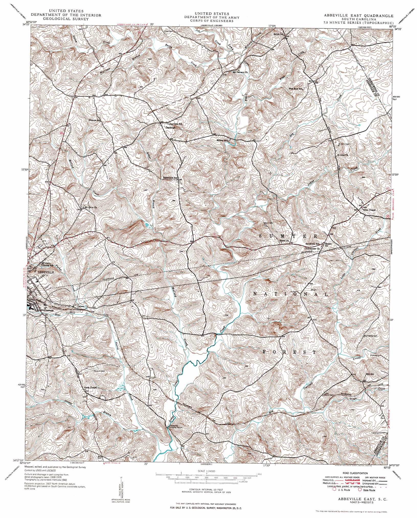
Abbeville East Topo Map South Carolina
To zoom in, hover over the map of Abbeville East
USGS Topo Quad 34082b3 - 1:24,000 scale
| Topo Map Name: | Abbeville East |
| USGS Topo Quad ID: | 34082b3 |
| Print Size: | ca. 21 1/4" wide x 27" high |
| Southeast Coordinates: | 34.125° N latitude / 82.25° W longitude |
| Map Center Coordinates: | 34.1875° N latitude / 82.3125° W longitude |
| U.S. State: | SC |
| Filename: | o34082b3.jpg |
| Download Map JPG Image: | Abbeville East topo map 1:24,000 scale |
| Map Type: | Topographic |
| Topo Series: | 7.5´ |
| Map Scale: | 1:24,000 |
| Source of Map Images: | United States Geological Survey (USGS) |
| Alternate Map Versions: |
Abbeville East SC 1948 Download PDF Buy paper map Abbeville East SC 1950 Download PDF Buy paper map Abbeville East SC 2011 Download PDF Buy paper map Abbeville East SC 2014 Download PDF Buy paper map |
| FStopo: | US Forest Service topo Abbeville East is available: Download FStopo PDF Download FStopo TIF |
1:24,000 Topo Quads surrounding Abbeville East
Saylors Crossroads |
Honea Path |
Ware Shoals West |
Ware Shoals East |
Laurens South |
Antreville |
Due West |
Shoals Junction |
Cokesbury |
Waterloo |
Latimer |
Abbeville West |
Abbeville East |
Greenwood |
Ninety Six |
Calhoun Falls |
Calhoun Creek |
Verdery |
Bradley |
Kirksey |
Chennault |
Willington |
Mccormick |
Winterseat |
Limestone |
> Back to 34082a1 at 1:100,000 scale
> Back to 34082a1 at 1:250,000 scale
> Back to U.S. Topo Maps home
Abbeville East topo map: Gazetteer
Abbeville East: Airports
Davis Field elevation 165m 541′Abbeville East: Bridges
Morton Bridge elevation 130m 426′Abbeville East: Dams
H D Poole Pond Dam D-3810 elevation 157m 515′Abbeville East: Populated Places
Cana (historical) elevation 135m 442′Darraugh elevation 183m 600′
Long Cane (historical) elevation 140m 459′
Millers Grove (historical) elevation 175m 574′
Millers Mill elevation 139m 456′
Shiloh elevation 181m 593′
Smithville elevation 177m 580′
Smithville (historical) elevation 182m 597′
Abbeville East: Rapids
Rapley Shoals elevation 139m 456′Abbeville East: Streams
Bagg Creek elevation 143m 469′Bailey Creek elevation 146m 479′
Blue Hill Creek elevation 136m 446′
Bowie Branch elevation 160m 524′
Double Branch elevation 119m 390′
Dry Creek elevation 130m 426′
Grays Creek elevation 130m 426′
Job Creek elevation 146m 479′
Johns Creek elevation 130m 426′
Keller Branch elevation 137m 449′
Little Curltail Creek elevation 133m 436′
Long Branch elevation 149m 488′
McCord Creek elevation 121m 396′
McCord Creek elevation 146m 479′
Morrison Branch elevation 154m 505′
Norris Creek elevation 117m 383′
Parker Creek elevation 137m 449′
Abbeville East digital topo map on disk
Buy this Abbeville East topo map showing relief, roads, GPS coordinates and other geographical features, as a high-resolution digital map file on DVD:
South Carolina, Western North Carolina & Northeastern Georgia
Buy digital topo maps: South Carolina, Western North Carolina & Northeastern Georgia