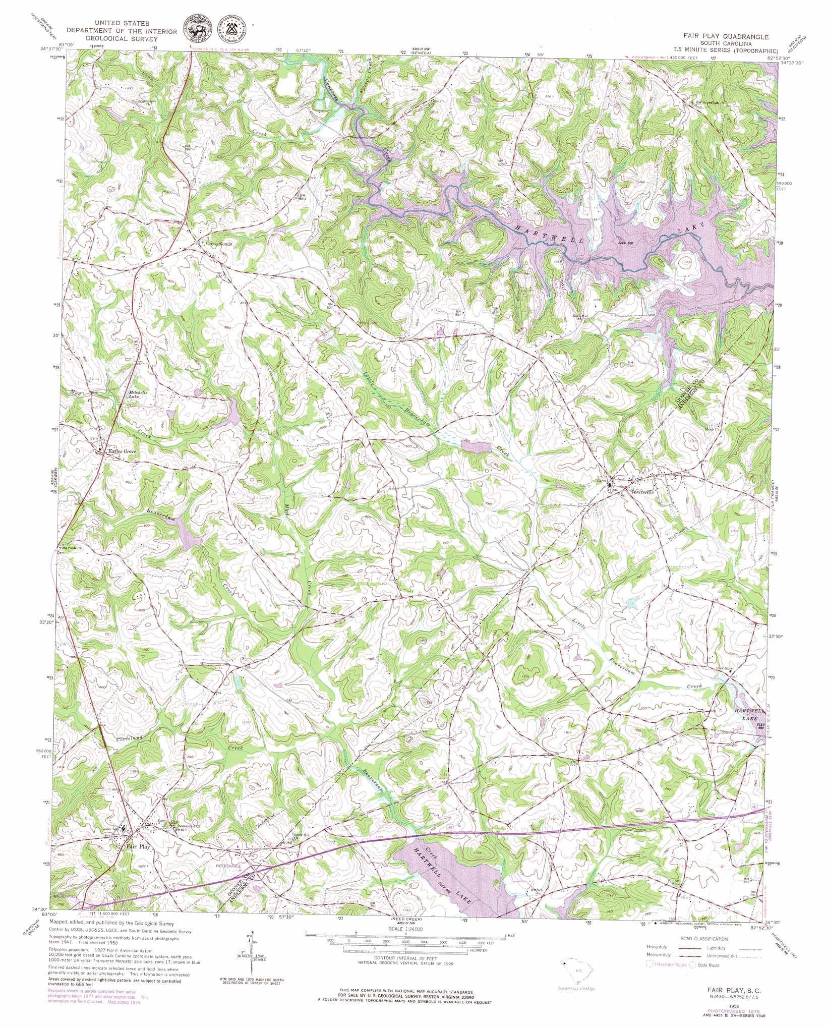
Fair Play Topo Map South Carolina
To zoom in, hover over the map of Fair Play
USGS Topo Quad 34082e8 - 1:24,000 scale
| Topo Map Name: | Fair Play |
| USGS Topo Quad ID: | 34082e8 |
| Print Size: | ca. 21 1/4" wide x 27" high |
| Southeast Coordinates: | 34.5° N latitude / 82.875° W longitude |
| Map Center Coordinates: | 34.5625° N latitude / 82.9375° W longitude |
| U.S. State: | SC |
| Filename: | o34082e8.jpg |
| Download Map JPG Image: | Fair Play topo map 1:24,000 scale |
| Map Type: | Topographic |
| Topo Series: | 7.5´ |
| Map Scale: | 1:24,000 |
| Source of Map Images: | United States Geological Survey (USGS) |
| Alternate Map Versions: |
Fair Play SC 1958, updated 1963 Download PDF Buy paper map Fair Play SC 1958, updated 1977 Download PDF Buy paper map Fair Play SC 1958, updated 1979 Download PDF Buy paper map Fair Play SC 1958, updated 1979 Download PDF Buy paper map Fair Play SC 2011 Download PDF Buy paper map Fair Play SC 2014 Download PDF Buy paper map |
1:24,000 Topo Quads surrounding Fair Play
Whetstone |
Walhalla |
Old Pickens |
Six Mile |
Liberty |
Holly Springs |
Westminster |
Seneca |
Clemson |
Five Forks |
Avalon |
Oakway |
Fair Play |
La France |
Anderson North |
Martin |
Lavonia |
Reed Creek |
Hartwell Ne |
Anderson South |
Carnesville |
Royston |
Hartwell |
Hartwell Dam |
Iva |
> Back to 34082e1 at 1:100,000 scale
> Back to 34082a1 at 1:250,000 scale
> Back to U.S. Topo Maps home
Fair Play topo map: Gazetteer
Fair Play: Crossings
Interchange 2 elevation 246m 807′Interchange 4 elevation 243m 797′
Fair Play: Dams
Beaverdam Creek WCD Dam Number Five D-1665 elevation 216m 708′Beaverdam Creek WCD Dam Number Four D-1667 elevation 220m 721′
Beaverdam Creek WCD Dam Number Two D-1666 elevation 232m 761′
Keaslers Pond Dam D-1630 elevation 250m 820′
Fair Play: Populated Places
Caballin Springs elevation 233m 764′Cross Roads elevation 282m 925′
Double Springs elevation 241m 790′
Earles Grove elevation 277m 908′
Fair Play elevation 248m 813′
Friendship Shores elevation 218m 715′
Seven Oaks elevation 231m 757′
Snug Harbor elevation 229m 751′
Timberlake elevation 232m 761′
Tokeena Point elevation 218m 715′
Townville elevation 249m 816′
Fair Play: Reservoirs
Beaverdam Watershed Five Lake elevation 216m 708′Beaverdam Watershed Four Lake elevation 220m 721′
Keaslers Pond elevation 250m 820′
Mitchells Lake elevation 255m 836′
Fair Play: Streams
Cleveland Creek elevation 205m 672′Mud Creek elevation 207m 679′
Snow Creek elevation 201m 659′
Speeds Creek elevation 200m 656′
Fair Play digital topo map on disk
Buy this Fair Play topo map showing relief, roads, GPS coordinates and other geographical features, as a high-resolution digital map file on DVD:
South Carolina, Western North Carolina & Northeastern Georgia
Buy digital topo maps: South Carolina, Western North Carolina & Northeastern Georgia