Pelham Topo Map South Carolina
To zoom in, hover over the map of Pelham
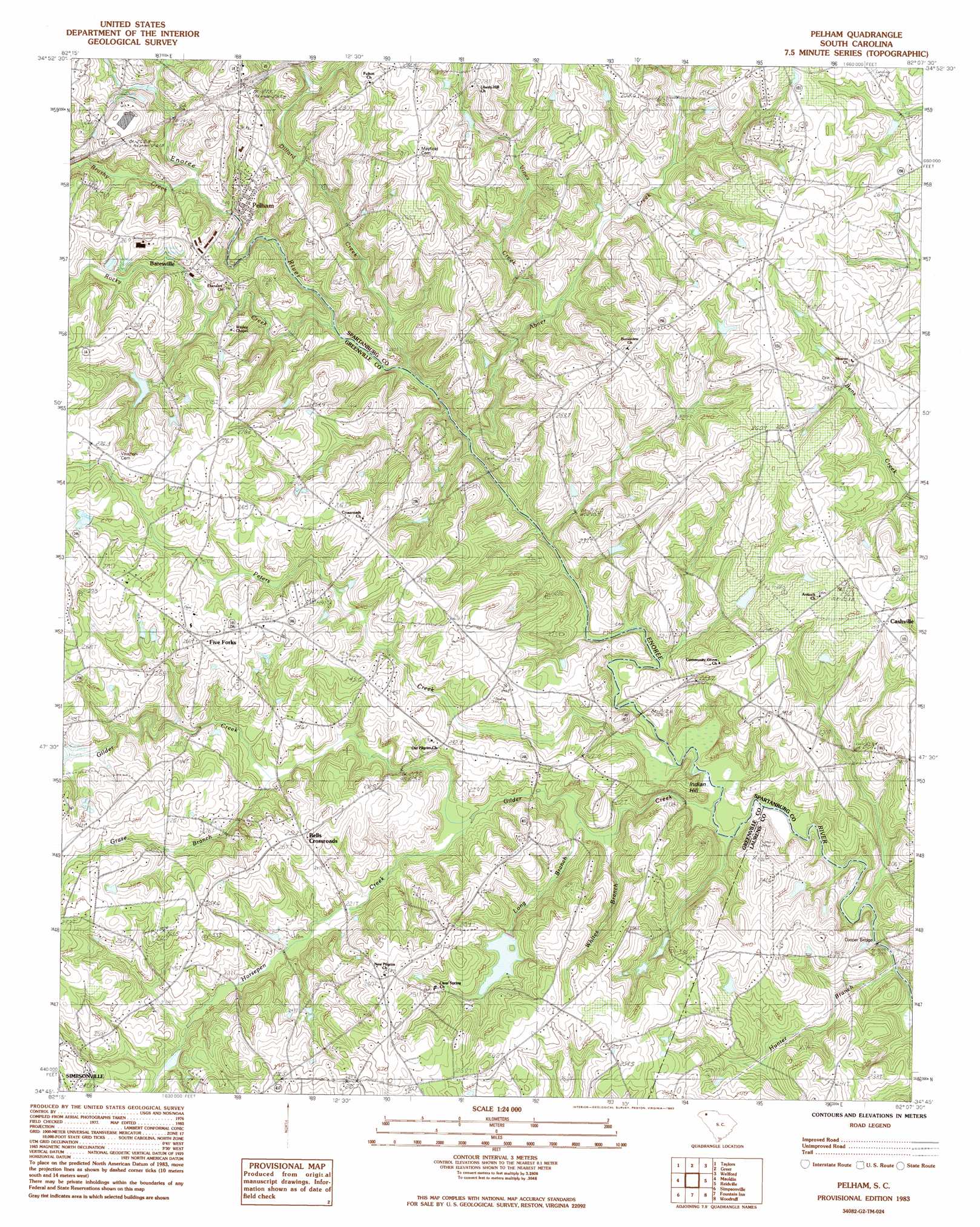
USGS Topo Quad 34082g2 - 1:24,000 scale
| Topo Map Name: | Pelham |
| USGS Topo Quad ID: | 34082g2 |
| Print Size: | ca. 21 1/4" wide x 27" high |
| Southeast Coordinates: | 34.75° N latitude / 82.125° W longitude |
| Map Center Coordinates: | 34.8125° N latitude / 82.1875° W longitude |
| U.S. State: | SC |
| Filename: | o34082g2.jpg |
| Download Map JPG Image: | Pelham topo map 1:24,000 scale |
| Map Type: | Topographic |
| Topo Series: | 7.5´ |
| Map Scale: | 1:24,000 |
| Source of Map Images: | United States Geological Survey (USGS) |
| Alternate Map Versions: |
Pelham SC 1983, updated 1983 Download PDF Buy paper map Pelham SC 1983, updated 1983 Download PDF Buy paper map Pelham SC 2011 Download PDF Buy paper map Pelham SC 2014 Download PDF Buy paper map |
1:24,000 Topo Quads surrounding Pelham
Slater |
Tigerville |
Campobello |
Inman |
Valley Falls |
Paris Mountain |
Taylors |
Greer |
Wellford |
Spartanburg |
Greenville |
Mauldin |
Pelham |
Reidville |
Moore |
Pelzer |
Simpsonville |
Fountain Inn |
Woodruff |
Enoree |
Belton East |
Fork Shoals |
Hickory Tavern |
Laurens North |
Ora |
> Back to 34082e1 at 1:100,000 scale
> Back to 34082a1 at 1:250,000 scale
> Back to U.S. Topo Maps home
Pelham topo map: Gazetteer
Pelham: Airports
Flight World Airport elevation 252m 826′Hughes Airport elevation 261m 856′
Pelham: Bars
Gibbs Shoals elevation 237m 777′Pelham: Bends
Horseshoe Bend elevation 220m 721′Pelham: Bridges
Anderson Bridge elevation 207m 679′Bennetts Bridge elevation 209m 685′
Cooper Bridge elevation 200m 656′
Ford Bridge (historical) elevation 201m 659′
Pelham: Crossings
Interchange 56 elevation 271m 889′Pelham: Dams
Bob Jones Farm Pond Dam D-2965 elevation 219m 718′E Antley Pond Dam D-2789 elevation 223m 731′
G Brockman Pond Dam D-3350 elevation 252m 826′
Gibbs Pond Dam D-3026 elevation 229m 751′
J Brockman Pond Dam D-2788 elevation 239m 784′
J P Stevens Pond Dam D-2901 elevation 262m 859′
South Carolina Noname 23005 D-2914 Dam elevation 239m 784′
Pelham: Falls
Pelham Falls elevation 219m 718′Pelham: Mines
Pelham Quarry elevation 272m 892′Pelham: Populated Places
Batesville elevation 250m 820′Bellingham elevation 250m 820′
Bells Crossroads elevation 252m 826′
Cashville elevation 249m 816′
Five Forks elevation 267m 875′
Pelham elevation 237m 777′
Ponderosa elevation 247m 810′
Woodland Village elevation 267m 875′
Pelham: Reservoirs
Bob Jones Farm Pond elevation 219m 718′G Brockman Pond elevation 252m 826′
Gibbs Pond elevation 229m 751′
Harpers Folly Lake elevation 239m 784′
J P Stevens Pond elevation 262m 859′
Pelham: Streams
Abner Creek elevation 217m 711′Brushy Creek elevation 231m 757′
Dillard Creek elevation 212m 695′
Gilder Creek elevation 201m 659′
Graze Branch elevation 221m 725′
Graze Creek elevation 221m 725′
Horsepen Creek elevation 213m 698′
Hunter Branch elevation 199m 652′
Little Gilder Creek elevation 235m 770′
Long Branch elevation 206m 675′
Peters Creek elevation 204m 669′
Rocky Creek elevation 218m 715′
Vines Creek elevation 209m 685′
Whites Branch elevation 206m 675′
Pelham: Summits
Indian Hill elevation 202m 662′Pelham digital topo map on disk
Buy this Pelham topo map showing relief, roads, GPS coordinates and other geographical features, as a high-resolution digital map file on DVD:
South Carolina, Western North Carolina & Northeastern Georgia
Buy digital topo maps: South Carolina, Western North Carolina & Northeastern Georgia