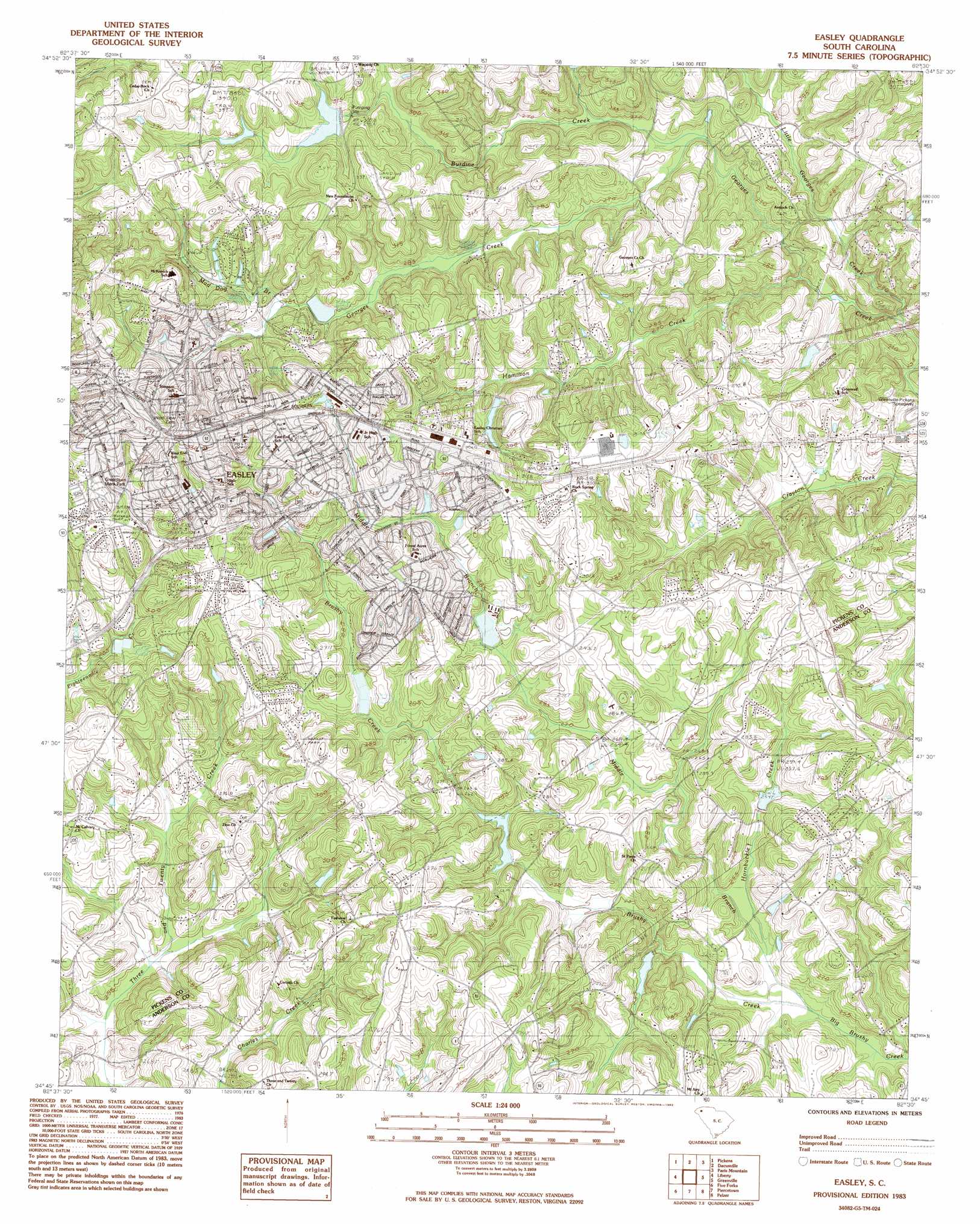
Easley Topo Map South Carolina
To zoom in, hover over the map of Easley
USGS Topo Quad 34082g5 - 1:24,000 scale
| Topo Map Name: | Easley |
| USGS Topo Quad ID: | 34082g5 |
| Print Size: | ca. 21 1/4" wide x 27" high |
| Southeast Coordinates: | 34.75° N latitude / 82.5° W longitude |
| Map Center Coordinates: | 34.8125° N latitude / 82.5625° W longitude |
| U.S. State: | SC |
| Filename: | o34082g5.jpg |
| Download Map JPG Image: | Easley topo map 1:24,000 scale |
| Map Type: | Topographic |
| Topo Series: | 7.5´ |
| Map Scale: | 1:24,000 |
| Source of Map Images: | United States Geological Survey (USGS) |
| Alternate Map Versions: |
Easley SC 1983, updated 1983 Download PDF Buy paper map Easley SC 2011 Download PDF Buy paper map Easley SC 2014 Download PDF Buy paper map |
1:24,000 Topo Quads surrounding Easley
Eastatoe Gap |
Table Rock |
Cleveland |
Slater |
Tigerville |
Sunset |
Pickens |
Dacusville |
Paris Mountain |
Taylors |
Six Mile |
Liberty |
Easley |
Greenville |
Mauldin |
Clemson |
Five Forks |
Piercetown |
Pelzer |
Simpsonville |
La France |
Anderson North |
Belton West |
Belton East |
Fork Shoals |
> Back to 34082e1 at 1:100,000 scale
> Back to 34082a1 at 1:250,000 scale
> Back to U.S. Topo Maps home
Easley topo map: Gazetteer
Easley: Dams
Brackers Pond Dam D-1924 elevation 273m 895′Forest Drive Pond Dam elevation 307m 1007′
Hendricks Pond Dam D-1941 elevation 320m 1049′
Hollen Pond Dam D-3138 elevation 259m 849′
Lyods Pond Dam D-1934 elevation 308m 1010′
South Carolina Noname 04004 D-3130 Dam elevation 271m 889′
South Carolina Noname 04005 D-3137 Dam elevation 275m 902′
South Carolina Noname 04006 D-3131 Dam elevation 291m 954′
South Carolina Noname 39004 D-1932 Dam elevation 295m 967′
South Carolina Noname 39012 D-1933 Dam elevation 322m 1056′
South Carolina Noname 39023 D-1942 Dam elevation 278m 912′
Watsons Pond Dam D-1936 elevation 295m 967′
Easley: Parks
Brice Field elevation 315m 1033′Easley Recreation Center elevation 333m 1092′
Hagood Park elevation 323m 1059′
Kings Park elevation 324m 1062′
Easley: Populated Places
Avondale Heights elevation 320m 1049′Botany Park elevation 326m 1069′
Briargate elevation 306m 1003′
Brookwood Heights elevation 309m 1013′
Burdine Springs elevation 309m 1013′
Canaan Land elevation 306m 1003′
Chadwick elevation 325m 1066′
Cherokee Forest elevation 318m 1043′
Countryside Manor elevation 302m 990′
Crestview Heights elevation 316m 1036′
Easley elevation 329m 1079′
Elaine Heights elevation 308m 1010′
Forest Acres elevation 322m 1056′
Forest Park elevation 303m 994′
Georgetown elevation 293m 961′
Glenwood elevation 321m 1053′
Hale elevation 309m 1013′
Hamilton Heights elevation 327m 1072′
Heathwood elevation 298m 977′
Holly Hill elevation 319m 1046′
Huntington North elevation 301m 987′
Huntington South elevation 291m 954′
Kingsberry elevation 323m 1059′
Lathem elevation 325m 1066′
Longcreek elevation 282m 925′
Marshall Heights elevation 316m 1036′
McDaniel Heights elevation 317m 1040′
Montague elevation 325m 1066′
Monte Vista elevation 348m 1141′
North Hills elevation 323m 1059′
Pageland elevation 308m 1010′
Perry Hills elevation 297m 974′
Pickensville elevation 330m 1082′
Shoals Creek Subdivision elevation 282m 925′
Smithfields elevation 297m 974′
Springdale elevation 309m 1013′
Timberlane elevation 299m 980′
Twinbrook elevation 303m 994′
Vista Heights elevation 302m 990′
Wyatt Acres elevation 310m 1017′
Yorkwood elevation 298m 977′
Easley: Post Offices
Blaine Post Office (historical) elevation 289m 948′Brushy Creek Post Office (historical) elevation 272m 892′
Easley Post Office elevation 322m 1056′
Easley: Reservoirs
Brackers Pond elevation 273m 895′Brushy Creek Watershed 11 Lake elevation 271m 889′
Brushy Creek Watershed 16 Lake elevation 275m 902′
Brushy Creek Watershed 17 Lake elevation 291m 954′
Forest Drive Pond elevation 307m 1007′
Georges Creek Watershed Structure elevation 322m 1056′
Hendricks Pond elevation 320m 1049′
Lyods Pond elevation 308m 1010′
Merritts Pond elevation 278m 912′
Watsons Pond elevation 295m 967′
Easley: Streams
Brushy Creek elevation 253m 830′Burdine Creek elevation 282m 925′
Georges Creek elevation 289m 948′
Hamilton Creek elevation 271m 889′
Hornbuckle Creek elevation 265m 869′
Little Georges Creek elevation 262m 859′
Middle Branch Brushy Creek elevation 253m 830′
Mud Dog Branch elevation 289m 948′
Easley digital topo map on disk
Buy this Easley topo map showing relief, roads, GPS coordinates and other geographical features, as a high-resolution digital map file on DVD:
South Carolina, Western North Carolina & Northeastern Georgia
Buy digital topo maps: South Carolina, Western North Carolina & Northeastern Georgia