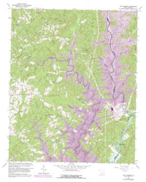
Old Pickens Topo Map South Carolina
To zoom in, hover over the map of Old Pickens
USGS Topo Quad 34082g8 - 1:24,000 scale
| Topo Map Name: | Old Pickens |
| USGS Topo Quad ID: | 34082g8 |
| Print Size: | ca. 21 1/4" wide x 27" high |
| Southeast Coordinates: | 34.75° N latitude / 82.875° W longitude |
| Map Center Coordinates: | 34.8125° N latitude / 82.9375° W longitude |
| U.S. State: | SC |
| Filename: | o34082g8.jpg |
| Download Map JPG Image: | Old Pickens topo map 1:24,000 scale |
| Map Type: | Topographic |
| Topo Series: | 7.5´ |
| Map Scale: | 1:24,000 |
| Source of Map Images: | United States Geological Survey (USGS) |
| Alternate Map Versions: |
Old Pickens SC 1961, updated 1964 Download PDF Buy paper map Old Pickens SC 1961, updated 1976 Download PDF Buy paper map Old Pickens SC 1961, updated 1981 Download PDF Buy paper map Old Pickens SC 2011 Download PDF Buy paper map Old Pickens SC 2014 Download PDF Buy paper map |
1:24,000 Topo Quads surrounding Old Pickens
> Back to 34082e1 at 1:100,000 scale
> Back to 34082a1 at 1:250,000 scale
> Back to U.S. Topo Maps home
Old Pickens topo map: Gazetteer
Old Pickens: Bends
Big Bend elevation 220m 721′Fork Bottom Bend elevation 266m 872′
Old Pickens: Bridges
Emerson Bridge elevation 244m 800′Flat Shoals Bridge elevation 270m 885′
Hunnicut Bridge elevation 244m 800′
Nimmons Bridge elevation 244m 800′
Nimmons Bridge (historical) elevation 244m 800′
Old Pickens Bridge elevation 198m 649′
Tanyard Bridge elevation 245m 803′
Old Pickens: Crossings
Robertsons Ford elevation 198m 649′Old Pickens: Dams
South Carolina Noname 39017 Dam elevation 244m 800′Old Pickens: Falls
High Falls elevation 244m 800′Old Pickens: Parks
DAR Monument elevation 259m 849′Mile Creek County Park elevation 268m 879′
Old Pickens: Populated Places
Dogwood Heights elevation 258m 846′Fernwood Acres elevation 302m 990′
Lakeside Estates elevation 260m 853′
Lakeside Mobile Home Park elevation 253m 830′
Old Pickens elevation 211m 692′
Saxony Forest elevation 274m 898′
Sugar Hill elevation 259m 849′
White Harbor elevation 265m 869′
Old Pickens: Reservoirs
Lake Keowee elevation 244m 800′Parker Lakes elevation 249m 816′
Old Pickens: Streams
Barkshed Branch elevation 244m 800′Beaman Branch elevation 245m 803′
Betty Branch elevation 244m 800′
Big Creek elevation 244m 800′
Camp Bottom Branch elevation 246m 807′
Caney Branch elevation 244m 800′
Cater Branch elevation 244m 800′
Cornhouse Creek elevation 244m 800′
Crow Creek elevation 244m 800′
Davis Branch elevation 250m 820′
Flat Shoals River elevation 261m 856′
Frenge Branch elevation 244m 800′
Kelly Creek elevation 244m 800′
Long Branch elevation 244m 800′
Mile Creek elevation 244m 800′
Neal Branch elevation 244m 800′
Oconee Creek elevation 253m 830′
Stamp Creek elevation 244m 800′
Todd Branch elevation 247m 810′
Von Hollen Creek elevation 244m 800′
Whetner Branch elevation 244m 800′
Whetstone Creek elevation 244m 800′
Wilson Branch elevation 244m 800′
Yarborough Branch elevation 249m 816′
Old Pickens digital topo map on disk
Buy this Old Pickens topo map showing relief, roads, GPS coordinates and other geographical features, as a high-resolution digital map file on DVD:
South Carolina, Western North Carolina & Northeastern Georgia
Buy digital topo maps: South Carolina, Western North Carolina & Northeastern Georgia


