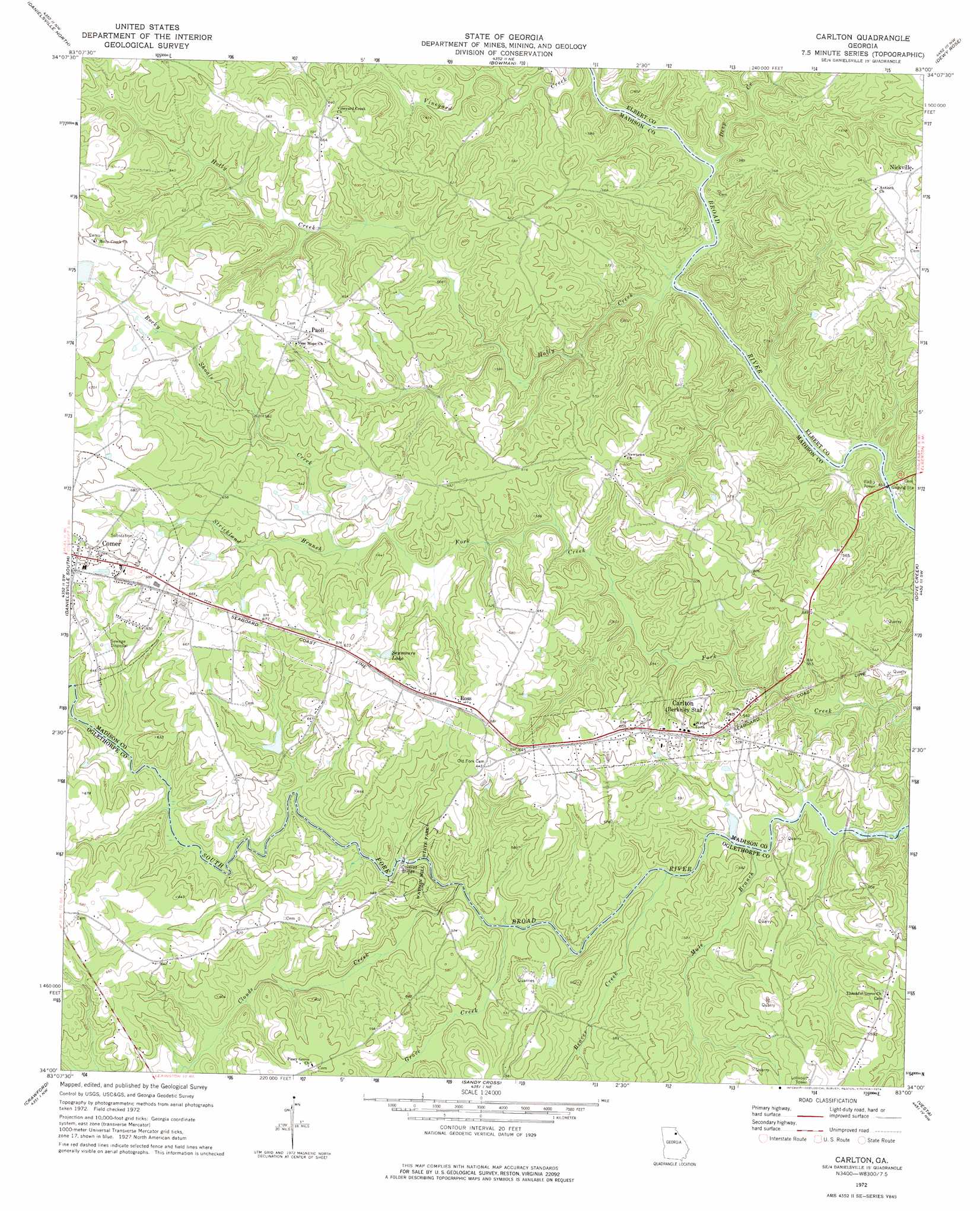
Carlton Topo Map Georgia
To zoom in, hover over the map of Carlton
USGS Topo Quad 34083a1 - 1:24,000 scale
| Topo Map Name: | Carlton |
| USGS Topo Quad ID: | 34083a1 |
| Print Size: | ca. 21 1/4" wide x 27" high |
| Southeast Coordinates: | 34° N latitude / 83° W longitude |
| Map Center Coordinates: | 34.0625° N latitude / 83.0625° W longitude |
| U.S. State: | GA |
| Filename: | o34083a1.jpg |
| Download Map JPG Image: | Carlton topo map 1:24,000 scale |
| Map Type: | Topographic |
| Topo Series: | 7.5´ |
| Map Scale: | 1:24,000 |
| Source of Map Images: | United States Geological Survey (USGS) |
| Alternate Map Versions: |
Carlton GA 1972, updated 1974 Download PDF Buy paper map Carlton GA 2011 Download PDF Buy paper map Carlton GA 2014 Download PDF Buy paper map |
1:24,000 Topo Quads surrounding Carlton
Ashland |
Carnesville |
Royston |
Hartwell |
Hartwell Dam |
Ila |
Danielsville North |
Bowman |
Dewy Rose |
Rock Branch |
Hull |
Danielsville South |
Carlton |
Elberton West |
Elberton East |
Athens East |
Crawford |
Sandy Cross |
Vesta |
Jacksons Crossroads |
Barnett Shoals |
Maxeys |
Lexington |
Rayle |
Celeste |
> Back to 34083a1 at 1:100,000 scale
> Back to 34082a1 at 1:250,000 scale
> Back to U.S. Topo Maps home
Carlton topo map: Gazetteer
Carlton: Bridges
Steel Bridge elevation 127m 416′Carlton: Crossings
Deadmans Ferry (historical) elevation 127m 416′Harpers Ferry (historical) elevation 129m 423′
Moon Ferry (historical) elevation 123m 403′
Carlton: Dams
Glenn Lake Dam elevation 148m 485′South Fork Broad River Number 64 Dam elevation 204m 669′
Whitehead Dam elevation 174m 570′
Carlton: Parks
Watson Mill State Park elevation 174m 570′Carlton: Populated Places
Carlton elevation 182m 597′Newtown elevation 194m 636′
Nickville elevation 182m 597′
Paoli elevation 211m 692′
Ross elevation 212m 695′
Smiths Store elevation 181m 593′
Vineyard Creek elevation 191m 626′
Carlton: Rapids
Cunningham Shoals elevation 153m 501′Watson Shoals elevation 167m 547′
Witcher Shoals elevation 156m 511′
Carlton: Reservoirs
Glenn Lake elevation 148m 485′Otter Run Lake elevation 147m 482′
Reservoir 64 elevation 204m 669′
Seymours Lake elevation 197m 646′
Whitehead Lake elevation 174m 570′
Carlton: Streams
Beaver Creek elevation 158m 518′Clouds Creek elevation 159m 521′
Deep Creek elevation 139m 456′
Grove Creek elevation 161m 528′
Holly Creek elevation 123m 403′
Mule Branch elevation 152m 498′
Rocky Shoals Creek elevation 176m 577′
Strickland Branch elevation 177m 580′
Carlton digital topo map on disk
Buy this Carlton topo map showing relief, roads, GPS coordinates and other geographical features, as a high-resolution digital map file on DVD:
South Carolina, Western North Carolina & Northeastern Georgia
Buy digital topo maps: South Carolina, Western North Carolina & Northeastern Georgia