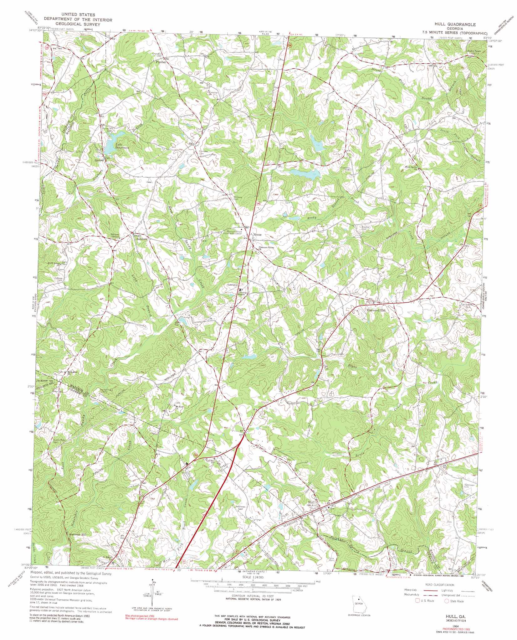
Hull Topo Map Georgia
To zoom in, hover over the map of Hull
USGS Topo Quad 34083a3 - 1:24,000 scale
| Topo Map Name: | Hull |
| USGS Topo Quad ID: | 34083a3 |
| Print Size: | ca. 21 1/4" wide x 27" high |
| Southeast Coordinates: | 34° N latitude / 83.25° W longitude |
| Map Center Coordinates: | 34.0625° N latitude / 83.3125° W longitude |
| U.S. State: | GA |
| Filename: | o34083a3.jpg |
| Download Map JPG Image: | Hull topo map 1:24,000 scale |
| Map Type: | Topographic |
| Topo Series: | 7.5´ |
| Map Scale: | 1:24,000 |
| Source of Map Images: | United States Geological Survey (USGS) |
| Alternate Map Versions: |
Hull GA 1964, updated 1965 Download PDF Buy paper map Hull GA 1964, updated 1989 Download PDF Buy paper map Hull GA 2011 Download PDF Buy paper map Hull GA 2014 Download PDF Buy paper map |
1:24,000 Topo Quads surrounding Hull
Maysville |
Homer |
Ashland |
Carnesville |
Royston |
Apple Valley |
Commerce |
Ila |
Danielsville North |
Bowman |
Jefferson |
Nicholson |
Hull |
Danielsville South |
Carlton |
Statham |
Athens West |
Athens East |
Crawford |
Sandy Cross |
High Shoals |
Watkinsville |
Barnett Shoals |
Maxeys |
Lexington |
> Back to 34083a1 at 1:100,000 scale
> Back to 34082a1 at 1:250,000 scale
> Back to U.S. Topo Maps home
Hull topo map: Gazetteer
Hull: Dams
Clark Fain Lake Dam elevation 253m 830′Hunnicutt Lake Dam elevation 222m 728′
Little Sandy Creek Structure Six Dam elevation 233m 764′
Muse Lake Dam elevation 243m 797′
Seagraves Mill Pond Dam elevation 246m 807′
South Fork Broad River Structure 10 Dam elevation 230m 754′
South Fork Broad River Structure 31 Dam elevation 205m 672′
South Fork Broad River Structure 35 Dam elevation 228m 748′
Hull: Populated Places
Barretts Mill elevation 204m 669′Cherokee Forest elevation 221m 725′
Country Corner Mobile Home Park elevation 249m 816′
Diamond Hill elevation 244m 800′
Diamond Rock (historical) elevation 231m 757′
Dogsboro elevation 261m 856′
Dowdy (historical) elevation 222m 728′
Hull elevation 250m 820′
Neese elevation 269m 882′
Planter elevation 270m 885′
Sanford elevation 273m 895′
Seagraves elevation 230m 754′
Trail Creek Estates Mobile Home Park elevation 245m 803′
Hull: Reservoirs
Clark Fain Lake elevation 253m 830′Enumber 16sandy Creek 0 Trail Creek elevation 222m 728′
Hunnicutt Lake elevation 222m 728′
Lake Seagraves elevation 234m 767′
Muse Lake elevation 243m 797′
Reservoir 31 elevation 205m 672′
Reservoir 35 elevation 228m 748′
Reservoir Six elevation 233m 764′
Reservoir U elevation 230m 754′
Sandy and Trail Creek Lake elevation 246m 807′
Sandy Creek O Trail Creek Lake elevation 224m 734′
Sandy Creek O Trail Creek Reservoir Number Two elevation 230m 754′
Sanford Lake elevation 229m 751′
Seagraves Mill Pond elevation 246m 807′
Hull: Streams
Lindsey Branch elevation 213m 698′Long Branch elevation 224m 734′
Nowhere Branch elevation 215m 705′
Rocky Branch elevation 224m 734′
South Creek elevation 198m 649′
Hull digital topo map on disk
Buy this Hull topo map showing relief, roads, GPS coordinates and other geographical features, as a high-resolution digital map file on DVD:
South Carolina, Western North Carolina & Northeastern Georgia
Buy digital topo maps: South Carolina, Western North Carolina & Northeastern Georgia