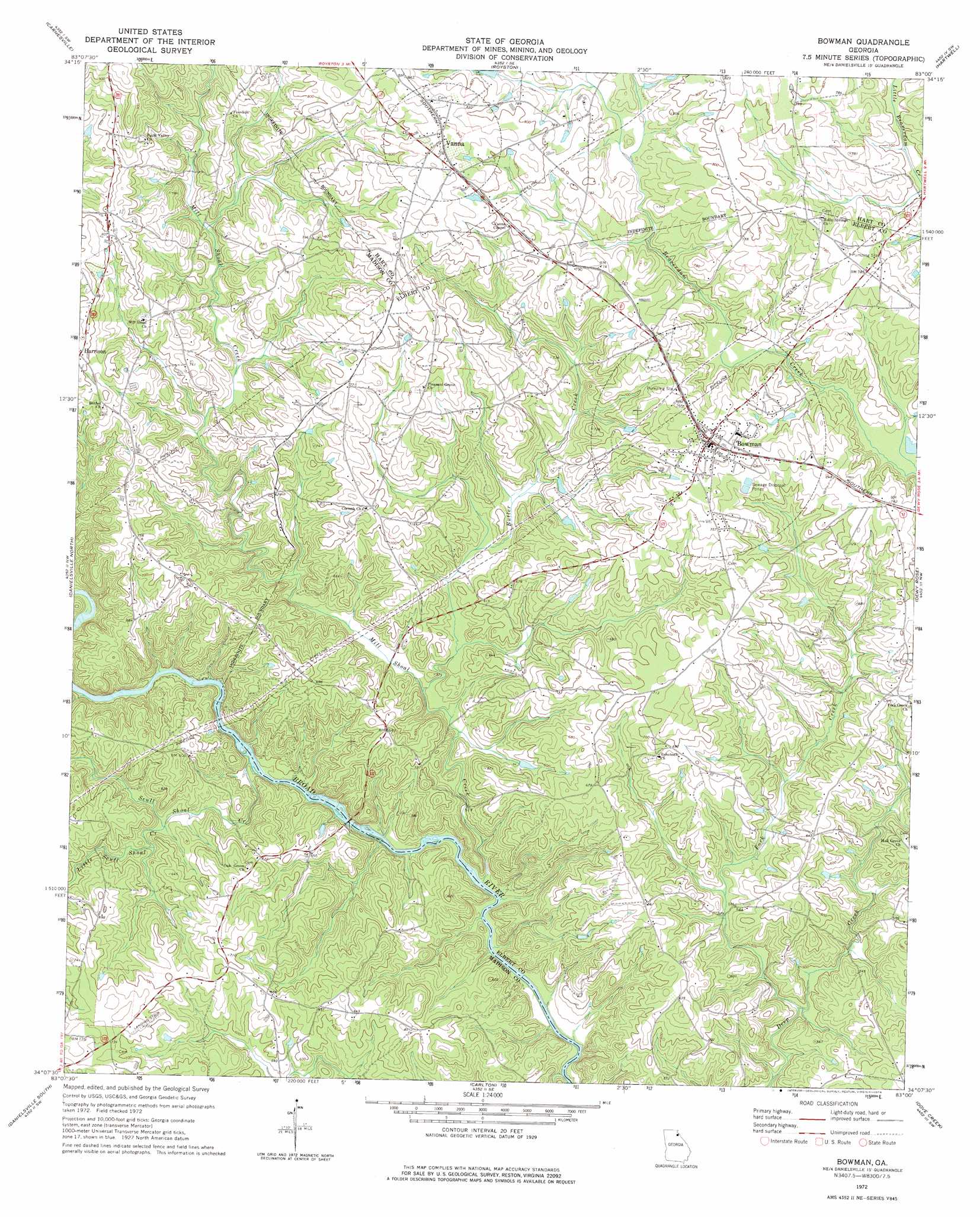
Bowman Topo Map Georgia
To zoom in, hover over the map of Bowman
USGS Topo Quad 34083b1 - 1:24,000 scale
| Topo Map Name: | Bowman |
| USGS Topo Quad ID: | 34083b1 |
| Print Size: | ca. 21 1/4" wide x 27" high |
| Southeast Coordinates: | 34.125° N latitude / 83° W longitude |
| Map Center Coordinates: | 34.1875° N latitude / 83.0625° W longitude |
| U.S. State: | GA |
| Filename: | o34083b1.jpg |
| Download Map JPG Image: | Bowman topo map 1:24,000 scale |
| Map Type: | Topographic |
| Topo Series: | 7.5´ |
| Map Scale: | 1:24,000 |
| Source of Map Images: | United States Geological Survey (USGS) |
| Alternate Map Versions: |
Bowman GA 1972, updated 1974 Download PDF Buy paper map Bowman GA 2011 Download PDF Buy paper map Bowman GA 2014 Download PDF Buy paper map |
1:24,000 Topo Quads surrounding Bowman
Red Hill |
Martin |
Lavonia |
Reed Creek |
Hartwell Ne |
Ashland |
Carnesville |
Royston |
Hartwell |
Hartwell Dam |
Ila |
Danielsville North |
Bowman |
Dewy Rose |
Rock Branch |
Hull |
Danielsville South |
Carlton |
Elberton West |
Elberton East |
Athens East |
Crawford |
Sandy Cross |
Vesta |
Jacksons Crossroads |
> Back to 34083a1 at 1:100,000 scale
> Back to 34082a1 at 1:250,000 scale
> Back to U.S. Topo Maps home
Bowman topo map: Gazetteer
Bowman: Bridges
New Lattice Bridge elevation 146m 479′Bowman: Crossings
Charles Moons Ferry (historical) elevation 136m 446′Moore Ferry (historical) elevation 140m 459′
Peytons Ferry (historical) elevation 133m 436′
Wilson Ferry (historical) elevation 152m 498′
Bowman: Populated Places
Bowman elevation 238m 780′Harrison elevation 247m 810′
Jeptha elevation 212m 695′
Match elevation 195m 639′
Reeds elevation 256m 839′
Seymours Store elevation 202m 662′
Vanna elevation 256m 839′
Bowman: Streams
Butler Creek elevation 173m 567′Fork Creek elevation 146m 479′
Little Scull Shoal Creek elevation 160m 524′
Mill Shoal Creek elevation 140m 459′
Scull Shoal Creek elevation 146m 479′
Vineyard Creek elevation 138m 452′
Bowman digital topo map on disk
Buy this Bowman topo map showing relief, roads, GPS coordinates and other geographical features, as a high-resolution digital map file on DVD:
South Carolina, Western North Carolina & Northeastern Georgia
Buy digital topo maps: South Carolina, Western North Carolina & Northeastern Georgia