Chestnut Mountain Topo Map Georgia
To zoom in, hover over the map of Chestnut Mountain
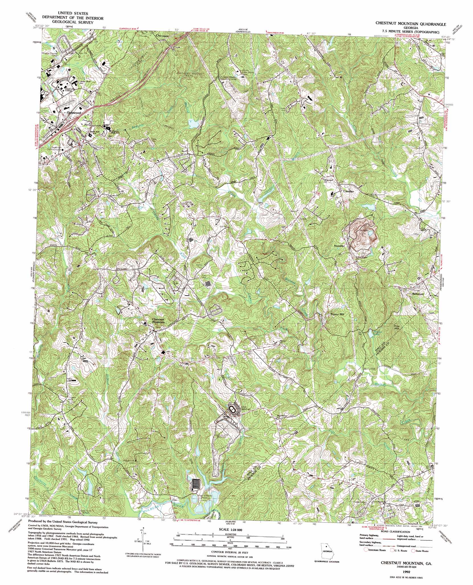
USGS Topo Quad 34083b7 - 1:24,000 scale
| Topo Map Name: | Chestnut Mountain |
| USGS Topo Quad ID: | 34083b7 |
| Print Size: | ca. 21 1/4" wide x 27" high |
| Southeast Coordinates: | 34.125° N latitude / 83.75° W longitude |
| Map Center Coordinates: | 34.1875° N latitude / 83.8125° W longitude |
| U.S. State: | GA |
| Filename: | o34083b7.jpg |
| Download Map JPG Image: | Chestnut Mountain topo map 1:24,000 scale |
| Map Type: | Topographic |
| Topo Series: | 7.5´ |
| Map Scale: | 1:24,000 |
| Source of Map Images: | United States Geological Survey (USGS) |
| Alternate Map Versions: |
Chestnut Mountain GA 1964, updated 1965 Download PDF Buy paper map Chestnut Mountain GA 1964, updated 1975 Download PDF Buy paper map Chestnut Mountain GA 1964, updated 1988 Download PDF Buy paper map Chestnut Mountain GA 1992, updated 1993 Download PDF Buy paper map Chestnut Mountain GA 2011 Download PDF Buy paper map Chestnut Mountain GA 2014 Download PDF Buy paper map |
1:24,000 Topo Quads surrounding Chestnut Mountain
Dawsonville |
Murrayville |
Clermont |
Lula |
Baldwin |
Coal Mountain |
Chestatee |
Gainesville |
Gillsville |
Maysville |
Buford Dam |
Flowery Branch |
Chestnut Mountain |
Pendergrass |
Apple Valley |
Suwanee |
Hog Mountain |
Auburn |
Winder North |
Jefferson |
Luxomni |
Lawrenceville |
Bold Springs |
Winder South |
Statham |
> Back to 34083a1 at 1:100,000 scale
> Back to 34082a1 at 1:250,000 scale
> Back to U.S. Topo Maps home
Chestnut Mountain topo map: Gazetteer
Chestnut Mountain: Crossings
Exit 4 elevation 372m 1220′Chestnut Mountain: Dams
Gainesville Stone Lake Dam elevation 294m 964′Middle Oconee Structure Number One Dam elevation 295m 967′
Chestnut Mountain: Parks
Chicopee Woods Park elevation 305m 1000′Platt Park elevation 312m 1023′
Chestnut Mountain: Populated Places
Alandale elevation 334m 1095′Belmont elevation 346m 1135′
Blackshear Place elevation 388m 1272′
Bolman Estates elevation 347m 1138′
Bretton Woods elevation 335m 1099′
Briarwood elevation 372m 1220′
Candler elevation 332m 1089′
Chestnut Hill elevation 329m 1079′
Chestnut Mountain elevation 347m 1138′
Colony South elevation 337m 1105′
Eaglewood elevation 323m 1059′
Ednaville elevation 286m 938′
Evergreen Heights elevation 357m 1171′
Frazier elevation 386m 1266′
Gilleland elevation 375m 1230′
Goochville elevation 275m 902′
Hillcroft Heights elevation 323m 1059′
Klondike elevation 342m 1122′
Marlette Heights elevation 309m 1013′
Meadowood elevation 346m 1135′
Mulberry elevation 348m 1141′
Pleasant Brook elevation 325m 1066′
Springfield Downs elevation 340m 1115′
Strickland Heights elevation 347m 1138′
Tanner Mill elevation 271m 889′
Chestnut Mountain: Reservoirs
Gainesville Stone Lake elevation 294m 964′McEver Lake elevation 263m 862′
Reservoir One elevation 295m 967′
Chestnut Mountain: Streams
Candler Branch elevation 280m 918′Caney Fork elevation 256m 839′
Cooper Creek elevation 247m 810′
Deaton Creek elevation 251m 823′
Lott Creek elevation 244m 800′
Mulberry Creek elevation 254m 833′
Redwine Creek elevation 305m 1000′
Sherwood Creek elevation 254m 833′
Chestnut Mountain: Summits
Kennedy Mountain elevation 363m 1190′Price Mountain elevation 367m 1204′
Chestnut Mountain digital topo map on disk
Buy this Chestnut Mountain topo map showing relief, roads, GPS coordinates and other geographical features, as a high-resolution digital map file on DVD:
South Carolina, Western North Carolina & Northeastern Georgia
Buy digital topo maps: South Carolina, Western North Carolina & Northeastern Georgia