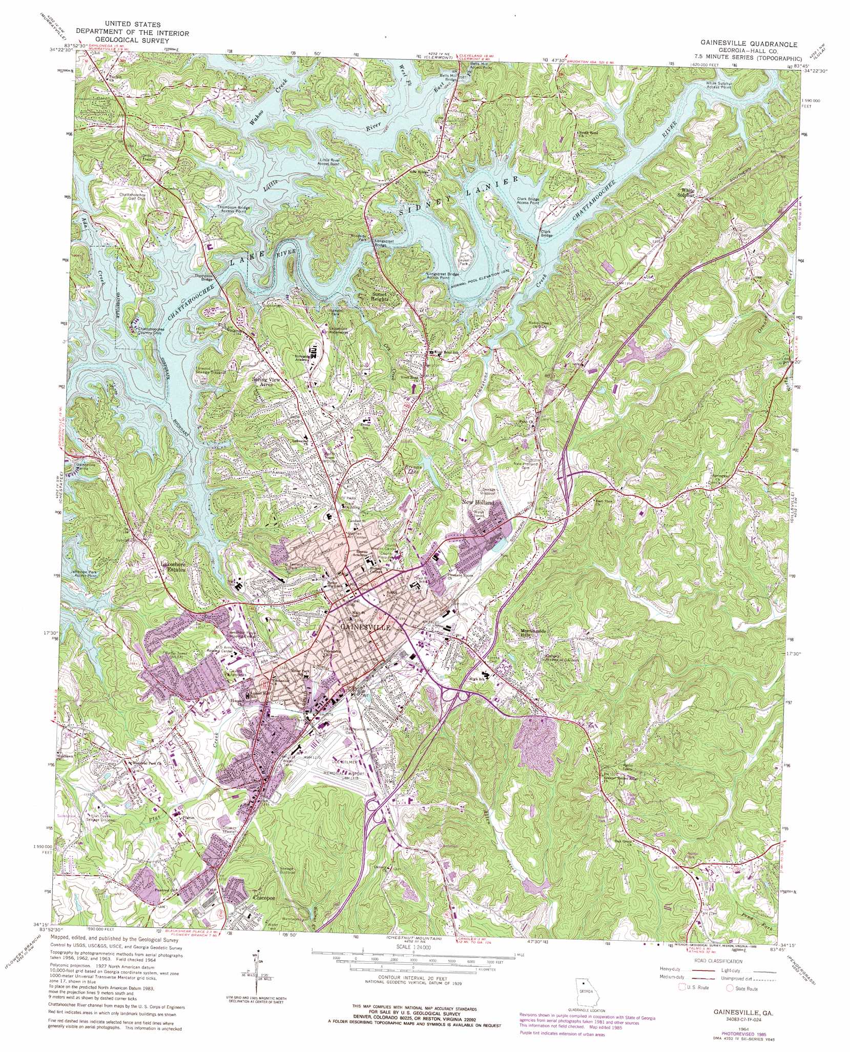
Gainesville Topo Map Georgia
To zoom in, hover over the map of Gainesville
USGS Topo Quad 34083c7 - 1:24,000 scale
| Topo Map Name: | Gainesville |
| USGS Topo Quad ID: | 34083c7 |
| Print Size: | ca. 21 1/4" wide x 27" high |
| Southeast Coordinates: | 34.25° N latitude / 83.75° W longitude |
| Map Center Coordinates: | 34.3125° N latitude / 83.8125° W longitude |
| U.S. State: | GA |
| Filename: | o34083c7.jpg |
| Download Map JPG Image: | Gainesville topo map 1:24,000 scale |
| Map Type: | Topographic |
| Topo Series: | 7.5´ |
| Map Scale: | 1:24,000 |
| Source of Map Images: | United States Geological Survey (USGS) |
| Alternate Map Versions: |
Gainesville GA 1964, updated 1965 Download PDF Buy paper map Gainesville GA 1964, updated 1972 Download PDF Buy paper map Gainesville GA 1964, updated 1975 Download PDF Buy paper map Gainesville GA 1964, updated 1986 Download PDF Buy paper map Gainesville GA 2011 Download PDF Buy paper map Gainesville GA 2014 Download PDF Buy paper map |
1:24,000 Topo Quads surrounding Gainesville
Campbell Mountain |
Dahlonega |
Cleveland |
Leaf |
Clarkesville |
Dawsonville |
Murrayville |
Clermont |
Lula |
Baldwin |
Coal Mountain |
Chestatee |
Gainesville |
Gillsville |
Maysville |
Buford Dam |
Flowery Branch |
Chestnut Mountain |
Pendergrass |
Apple Valley |
Suwanee |
Hog Mountain |
Auburn |
Winder North |
Jefferson |
> Back to 34083a1 at 1:100,000 scale
> Back to 34082a1 at 1:250,000 scale
> Back to U.S. Topo Maps home
Gainesville topo map: Gazetteer
Gainesville: Airports
Lanier Park Hospital Heliport elevation 349m 1145′Lee Gilmer Memorial Airport elevation 387m 1269′
Gainesville: Bridges
Bells Mill Bridge elevation 326m 1069′Clark Bridge elevation 326m 1069′
Clark Bridge Access Point elevation 329m 1079′
Longstreet Bridge elevation 326m 1069′
Longstreet Bridge Access Point elevation 326m 1069′
Thompson Bridge elevation 326m 1069′
Thompson Bridge Access Point elevation 328m 1076′
Gainesville: Crossings
Exit 5 elevation 390m 1279′Exit 6 elevation 365m 1197′
Exit 7 elevation 365m 1197′
Stringer Ford (historical) elevation 326m 1069′
Gainesville: Dams
Brenau Lake Dam elevation 353m 1158′Middle Oconee Structure Number Seven Dam elevation 307m 1007′
Ramsey-Fraser Lake Dam elevation 305m 1000′
Gainesville: Parks
Brenau College Historic District elevation 385m 1263′Chicopee Mill and Village Historic District elevation 377m 1236′
Dogwood Park elevation 342m 1122′
Green Street-Brenau Historic District elevation 388m 1272′
Highway Fiftythree Access Point elevation 328m 1076′
Holly Park elevation 331m 1085′
Ivy Terrace Park elevation 358m 1174′
Laurel Park elevation 333m 1092′
Roper Park elevation 381m 1250′
Yonah Park elevation 372m 1220′
Gainesville: Populated Places
Ahaluna elevation 364m 1194′Atlas Circle elevation 385m 1263′
Bailey elevation 391m 1282′
Barrett elevation 373m 1223′
Beverly Hills elevation 342m 1122′
Blueberry Hills elevation 347m 1138′
Botany Woods elevation 345m 1131′
Camellia Heights elevation 390m 1279′
Cascade Woods elevation 373m 1223′
Chapman elevation 346m 1135′
Chattahoochee Landing elevation 359m 1177′
Chattahoochee Place elevation 378m 1240′
Cherokee Meadows elevation 346m 1135′
Cherrywood elevation 359m 1177′
Chestnut Oak Hills elevation 376m 1233′
Chicopee elevation 376m 1233′
Clarks Bridge elevation 362m 1187′
Country Club Gardens elevation 390m 1279′
Dixie Hills elevation 346m 1135′
Fleetwood elevation 377m 1236′
Fox Hollow elevation 356m 1167′
Frontier Trail elevation 338m 1108′
Gainesville elevation 381m 1250′
Gainesville Mills elevation 373m 1223′
Gower Springs (historical) elevation 384m 1259′
Green Hills elevation 358m 1174′
Greenway elevation 356m 1167′
Greystone elevation 366m 1200′
Griffin Heights elevation 349m 1145′
Happy Valley elevation 350m 1148′
Hayes elevation 350m 1148′
Holland elevation 363m 1190′
Kemp elevation 354m 1161′
Lakeland Heights elevation 348m 1141′
Lakeshore Estates elevation 366m 1200′
Lanier North Woods elevation 351m 1151′
Lanier Valley elevation 339m 1112′
Laurel Hills elevation 349m 1145′
Le Dan elevation 370m 1213′
Mill Creek elevation 344m 1128′
Mooney elevation 366m 1200′
Morning Side Hills elevation 388m 1272′
New Holland elevation 360m 1181′
North Banks Cove elevation 368m 1207′
Northcliff Colony elevation 375m 1230′
Northlake elevation 348m 1141′
Oakhill elevation 330m 1082′
Pine Point elevation 366m 1200′
Quiet Place in the Woods elevation 353m 1158′
Rabbitown elevation 376m 1233′
Rainbow Village elevation 379m 1243′
River Point elevation 351m 1151′
Riverbend elevation 369m 1210′
Sagamore elevation 363m 1190′
Scoutland elevation 340m 1115′
Shady Lane elevation 351m 1151′
Shady Valley elevation 336m 1102′
Shamrock Heights elevation 350m 1148′
Spring View Acres elevation 379m 1243′
Stevens elevation 356m 1167′
Sundown on Lanier elevation 342m 1122′
Sunset Heights elevation 361m 1184′
Surf Side Club Estates elevation 351m 1151′
Tapawingo elevation 366m 1200′
The Bluffs elevation 349m 1145′
Thompson Mill elevation 348m 1141′
Tumlin Heights elevation 371m 1217′
Tyner elevation 373m 1223′
Waterford elevation 340m 1115′
Westgate elevation 382m 1253′
Westside elevation 374m 1227′
White Sands elevation 364m 1194′
White Sulphur elevation 367m 1204′
White Sulphur Springs elevation 288m 944′
White Sulphur Station (historical) elevation 364m 1194′
Wild Fern elevation 364m 1194′
Wildwood Heights elevation 374m 1227′
Woodlake elevation 354m 1161′
Gainesville: Post Offices
Gainesville Post Office elevation 386m 1266′Gainesville: Reservoirs
Brenau Lake elevation 353m 1158′Ramsey-Fraser Lake elevation 305m 1000′
Reservoir Seven elevation 307m 1007′
Gainesville: Streams
Ada Creek elevation 326m 1069′Cry Creek elevation 326m 1069′
East Fork Little River elevation 326m 1069′
Limestone Creek elevation 326m 1069′
Little River elevation 326m 1069′
Wahoo Creek elevation 326m 1069′
West Fork Little River elevation 326m 1069′
Gainesville digital topo map on disk
Buy this Gainesville topo map showing relief, roads, GPS coordinates and other geographical features, as a high-resolution digital map file on DVD:
South Carolina, Western North Carolina & Northeastern Georgia
Buy digital topo maps: South Carolina, Western North Carolina & Northeastern Georgia