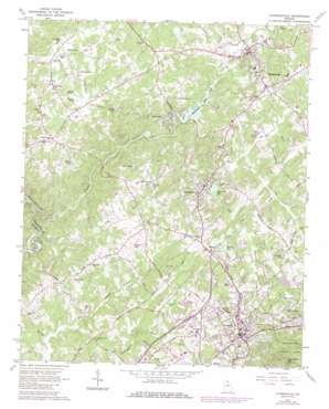
Clarkesville Topo Map Georgia
To zoom in, hover over the map of Clarkesville
USGS Topo Quad 34083e5 - 1:24,000 scale
| Topo Map Name: | Clarkesville |
| USGS Topo Quad ID: | 34083e5 |
| Print Size: | ca. 21 1/4" wide x 27" high |
| Southeast Coordinates: | 34.5° N latitude / 83.5° W longitude |
| Map Center Coordinates: | 34.5625° N latitude / 83.5625° W longitude |
| U.S. State: | GA |
| Filename: | o34083e5.jpg |
| Download Map JPG Image: | Clarkesville topo map 1:24,000 scale |
| Map Type: | Topographic |
| Topo Series: | 7.5´ |
| Map Scale: | 1:24,000 |
| Source of Map Images: | United States Geological Survey (USGS) |
| Alternate Map Versions: |
Clarkesville GA 1964, updated 1965 Download PDF Buy paper map Clarkesville GA 1964, updated 1986 Download PDF Buy paper map Clarkesville GA 2011 Download PDF Buy paper map Clarkesville GA 2014 Download PDF Buy paper map |
| FStopo: | US Forest Service topo Clarkesville is available: Download FStopo PDF Download FStopo TIF |
1:24,000 Topo Quads surrounding Clarkesville
> Back to 34083e1 at 1:100,000 scale
> Back to 34082a1 at 1:250,000 scale
> Back to U.S. Topo Maps home
Clarkesville topo map: Gazetteer
Clarkesville: Airports
Habersham County Airport elevation 440m 1443′Clarkesville: Bridges
Cannons Bridge elevation 392m 1286′Duncan Bridge elevation 346m 1135′
Judge I Homer Sutton Bridge elevation 391m 1282′
Clarkesville: Crossings
Heads Ferry (historical) elevation 345m 1131′Clarkesville: Dams
Demorest Lake Dam elevation 397m 1302′Habersham Mills Lake Dam elevation 390m 1279′
Hazel Creek Watershed Structure Number Seven Dam elevation 429m 1407′
Thin River Orchard Dam elevation 397m 1302′
Clarkesville: Parks
Cornelia City Park elevation 484m 1587′Demorest Commercial Historic District elevation 411m 1348′
South Washington Street Historic District elevation 434m 1423′
Veterans of Foreign Wars Memorial Park elevation 412m 1351′
Washington-Jefferson Street Historic District elevation 418m 1371′
Clarkesville: Populated Places
Bert (historical) elevation 408m 1338′Clarkesville elevation 413m 1354′
Cornelia elevation 461m 1512′
Demorest elevation 411m 1348′
Fairview elevation 439m 1440′
Habersham elevation 382m 1253′
Habersham Station (historical) elevation 433m 1420′
Hills elevation 437m 1433′
Midway elevation 436m 1430′
Mount Airy elevation 471m 1545′
Pardue Mill elevation 382m 1253′
Soquee (historical) elevation 397m 1302′
Clarkesville: Post Offices
Cornelia Post Office elevation 456m 1496′Habersham Post Office elevation 393m 1289′
Clarkesville: Reservoirs
Adams Pond elevation 415m 1361′Barrett Pond elevation 419m 1374′
Bassinger Pond elevation 445m 1459′
Black Pond elevation 440m 1443′
Blair Pond elevation 435m 1427′
Demorest Lake elevation 397m 1302′
Ellers Lake elevation 392m 1286′
English Pond elevation 413m 1354′
Ferguson Pond elevation 419m 1374′
Habersham Mills Lake elevation 390m 1279′
Hazel Creek elevation 429m 1407′
Lewis Ponds elevation 399m 1309′
Millers Pond elevation 389m 1276′
Millers Pond elevation 423m 1387′
Mulkey Lake elevation 419m 1374′
Shore Pond elevation 422m 1384′
Sutton Pond elevation 431m 1414′
Thin River Orchard Lake elevation 397m 1302′
Thomas Pond elevation 421m 1381′
Clarkesville: Streams
Beaverdam Creek elevation 395m 1295′Camp Creek elevation 390m 1279′
Cornelia Branch elevation 405m 1328′
Hazel Creek elevation 360m 1181′
Law Creek elevation 396m 1299′
Lick Log Creek elevation 394m 1292′
Little Hazel Creek elevation 400m 1312′
North Fork Little Mud Creek elevation 388m 1272′
North Fork Mud Creek elevation 395m 1295′
Perkins Branch elevation 381m 1250′
Soquee River elevation 345m 1131′
South Fork Little Mud Creek elevation 389m 1276′
South Fork Mud Creek elevation 395m 1295′
Sutton Mill Creek elevation 395m 1295′
Yellowbank Creek elevation 353m 1158′
Clarkesville: Summits
Chenocetah Mountain elevation 552m 1811′Clarkesville digital topo map on disk
Buy this Clarkesville topo map showing relief, roads, GPS coordinates and other geographical features, as a high-resolution digital map file on DVD:
South Carolina, Western North Carolina & Northeastern Georgia
Buy digital topo maps: South Carolina, Western North Carolina & Northeastern Georgia


