Holly Springs Topo Map South Carolina
To zoom in, hover over the map of Holly Springs
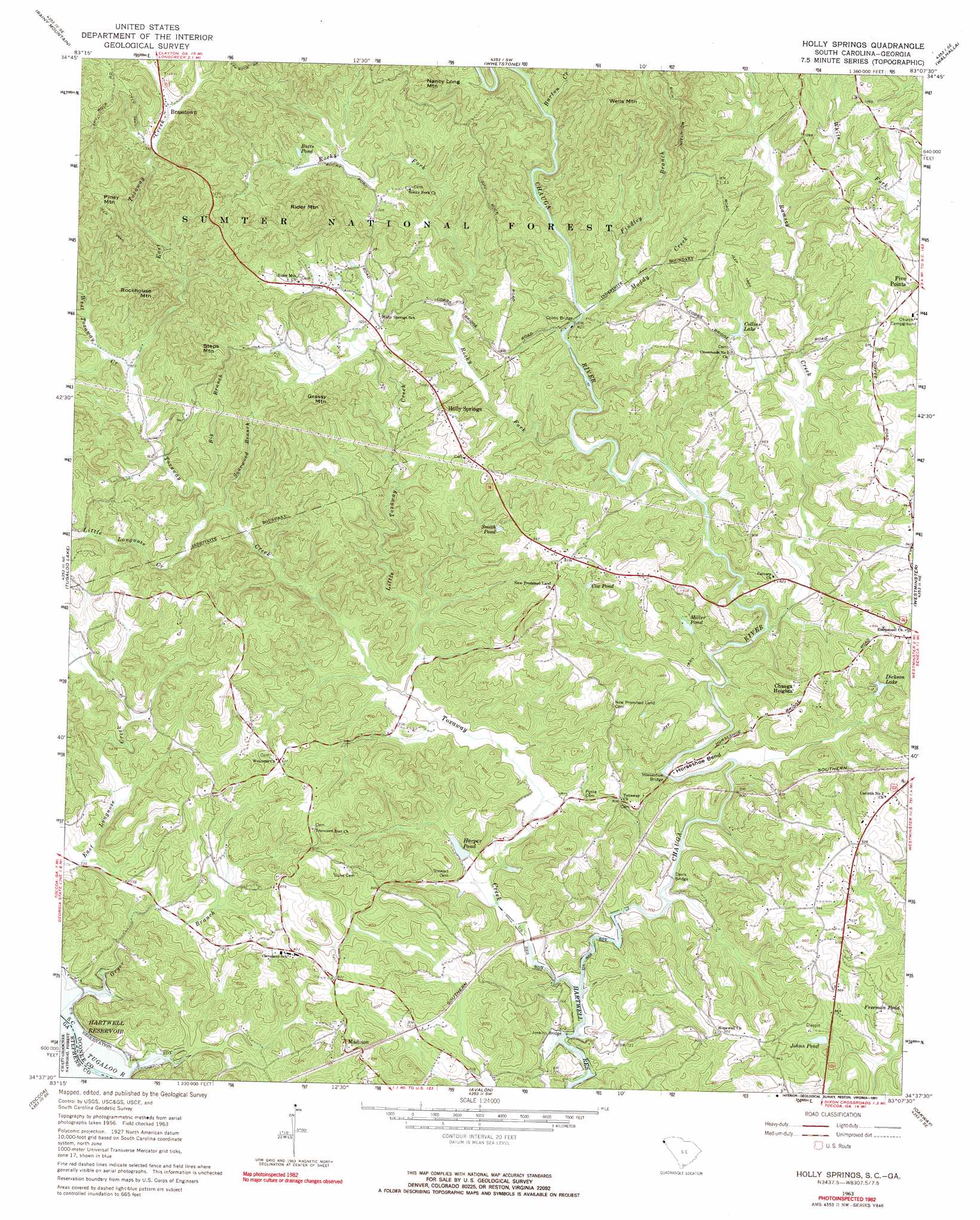
USGS Topo Quad 34083f2 - 1:24,000 scale
| Topo Map Name: | Holly Springs |
| USGS Topo Quad ID: | 34083f2 |
| Print Size: | ca. 21 1/4" wide x 27" high |
| Southeast Coordinates: | 34.625° N latitude / 83.125° W longitude |
| Map Center Coordinates: | 34.6875° N latitude / 83.1875° W longitude |
| U.S. States: | SC, GA |
| Filename: | o34083f2.jpg |
| Download Map JPG Image: | Holly Springs topo map 1:24,000 scale |
| Map Type: | Topographic |
| Topo Series: | 7.5´ |
| Map Scale: | 1:24,000 |
| Source of Map Images: | United States Geological Survey (USGS) |
| Alternate Map Versions: |
Holly Springs SC 1963, updated 1964 Download PDF Buy paper map Holly Springs SC 1963, updated 1991 Download PDF Buy paper map Holly Springs SC 2011 Download PDF Buy paper map Holly Springs SC 2014 Download PDF Buy paper map |
| FStopo: | US Forest Service topo Holly Springs is available: Download FStopo PDF Download FStopo TIF |
1:24,000 Topo Quads surrounding Holly Springs
Dillard |
Rabun Bald |
Satolah |
Tamassee |
Salem |
Tiger |
Rainy Mountain |
Whetstone |
Walhalla |
Old Pickens |
Tallulah Falls |
Tugaloo Lake |
Holly Springs |
Westminster |
Seneca |
Ayersville |
Toccoa |
Avalon |
Oakway |
Fair Play |
Russell Lake |
Red Hill |
Martin |
Lavonia |
Reed Creek |
> Back to 34083e1 at 1:100,000 scale
> Back to 34082a1 at 1:250,000 scale
> Back to U.S. Topo Maps home
Holly Springs topo map: Gazetteer
Holly Springs: Bends
Horseshoe Bend elevation 234m 767′Holly Springs: Bridges
Cobbs Bridge elevation 249m 816′Davis Bridge elevation 204m 669′
Horseshoe Bridge elevation 211m 692′
Jenkins Bridge elevation 198m 649′
Holly Springs: Dams
Harper Pond Dam D-1661 elevation 213m 698′Hicks Pond Dam D-1659 elevation 210m 688′
Holly Springs: Lakes
Cox Pond elevation 265m 869′Holly Springs: Populated Places
Brasstown elevation 416m 1364′Chauga Heights elevation 287m 941′
Harbin (historical) elevation 224m 734′
Holly Springs elevation 319m 1046′
Horse Shoe (historical) elevation 215m 705′
Madison elevation 249m 816′
Percival Crossroads elevation 281m 921′
Holly Springs: Reservoirs
Butts Pond elevation 315m 1033′Collins Lake elevation 280m 918′
Dickson Lake elevation 240m 787′
Harper Pond elevation 213m 698′
Harper Pond elevation 275m 902′
Hicks Pond elevation 210m 688′
Johns Pond elevation 255m 836′
Miller Pond elevation 233m 764′
Smith Pond elevation 270m 885′
Holly Springs: Streams
Barton Creek elevation 263m 862′Big Branch elevation 236m 774′
Devils Fork Creek elevation 266m 872′
East Toxaway Creek elevation 246m 807′
Findley Branch elevation 259m 849′
Gryer Branch elevation 202m 662′
Little Longnose Creek elevation 230m 754′
Little Toxaway Creek elevation 213m 698′
Muddy Creek elevation 247m 810′
Ramsey Creek elevation 216m 708′
Rocky Fork elevation 234m 767′
Sourwood Branch elevation 230m 754′
Toxaway Creek elevation 200m 656′
West Toxaway Creek elevation 247m 810′
Holly Springs: Summits
Grassy Mountain elevation 397m 1302′Nancy Long Mountain elevation 407m 1335′
Piney Mountain elevation 450m 1476′
Rider Mountain elevation 475m 1558′
Rockhouse Mountain elevation 415m 1361′
Steps Mountain elevation 425m 1394′
Wells Mountain elevation 502m 1646′
Holly Springs digital topo map on disk
Buy this Holly Springs topo map showing relief, roads, GPS coordinates and other geographical features, as a high-resolution digital map file on DVD:
South Carolina, Western North Carolina & Northeastern Georgia
Buy digital topo maps: South Carolina, Western North Carolina & Northeastern Georgia