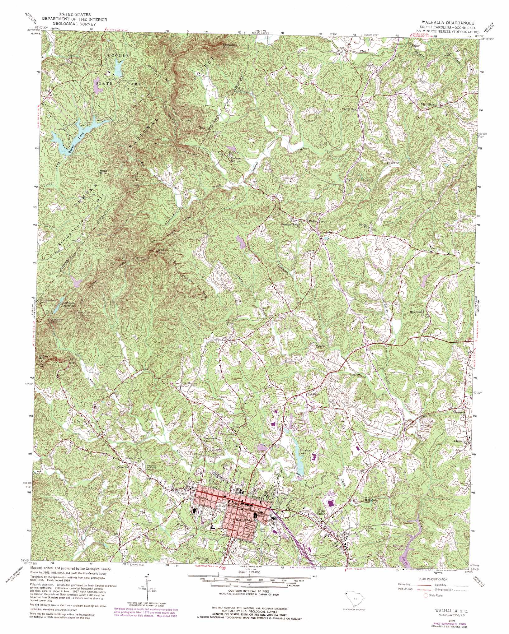
Walhalla Topo Map South Carolina
To zoom in, hover over the map of Walhalla
USGS Topo Quad 34083g1 - 1:24,000 scale
| Topo Map Name: | Walhalla |
| USGS Topo Quad ID: | 34083g1 |
| Print Size: | ca. 21 1/4" wide x 27" high |
| Southeast Coordinates: | 34.75° N latitude / 83° W longitude |
| Map Center Coordinates: | 34.8125° N latitude / 83.0625° W longitude |
| U.S. State: | SC |
| Filename: | o34083g1.jpg |
| Download Map JPG Image: | Walhalla topo map 1:24,000 scale |
| Map Type: | Topographic |
| Topo Series: | 7.5´ |
| Map Scale: | 1:24,000 |
| Source of Map Images: | United States Geological Survey (USGS) |
| Alternate Map Versions: |
Walhalla SC 1959, updated 1960 Download PDF Buy paper map Walhalla SC 1959, updated 1969 Download PDF Buy paper map Walhalla SC 1959, updated 1981 Download PDF Buy paper map Walhalla SC 1959, updated 1990 Download PDF Buy paper map Walhalla SC 1959, updated 1990 Download PDF Buy paper map Walhalla SC 2011 Download PDF Buy paper map Walhalla SC 2014 Download PDF Buy paper map |
| FStopo: | US Forest Service topo Walhalla is available: Download FStopo PDF Download FStopo TIF |
1:24,000 Topo Quads surrounding Walhalla
Scaly Mountain |
Highlands |
Cashiers |
Reid |
Eastatoe Gap |
Rabun Bald |
Satolah |
Tamassee |
Salem |
Sunset |
Rainy Mountain |
Whetstone |
Walhalla |
Old Pickens |
Six Mile |
Tugaloo Lake |
Holly Springs |
Westminster |
Seneca |
Clemson |
Toccoa |
Avalon |
Oakway |
Fair Play |
La France |
> Back to 34083e1 at 1:100,000 scale
> Back to 34082a1 at 1:250,000 scale
> Back to U.S. Topo Maps home
Walhalla topo map: Gazetteer
Walhalla: Crossings
Rocky Ford elevation 321m 1053′Walhalla: Dams
Bookers Lake Dam D-1646 elevation 327m 1072′Mountain Lake Dam D-1641 elevation 500m 1640′
Oconee State Park Dam Number One D-1642 elevation 525m 1722′
South Carolina Noname 37011 D-1651 Dam elevation 284m 931′
South Carolina Noname 37031 D-1643 Dam elevation 510m 1673′
Walhalla Reservoir Dam D-1647 elevation 436m 1430′
Walhalla: Falls
Isaqueena Falls elevation 373m 1223′Walhalla: Gaps
Hi Saw Gap elevation 435m 1427′Walhalla: Parks
Oconee State Park elevation 526m 1725′Station Creek Cove Botanical Area elevation 339m 1112′
Walhalla: Populated Places
Burns Mill elevation 270m 885′Camp Oak elevation 351m 1151′
Colonial Heights elevation 295m 967′
Country Villa Subdivision elevation 301m 987′
Crystal Falls elevation 293m 961′
Dutch Fork elevation 300m 984′
Eastcliff elevation 300m 984′
Ebenezer elevation 313m 1026′
Flat Shoals elevation 325m 1066′
Forest Acres elevation 320m 1049′
Oakmont elevation 290m 951′
Picket Post elevation 336m 1102′
Springdale elevation 289m 948′
Walhalla elevation 315m 1033′
West Union elevation 303m 994′
Woodland Trailer Park elevation 300m 984′
Walhalla: Post Offices
Pickett Post Office (historical) elevation 338m 1108′Walhalla Post Office elevation 314m 1030′
West Union Post Office elevation 304m 997′
Walhalla: Reservoirs
Bookers Lake elevation 327m 1072′Browns Lake elevation 284m 931′
Lake Becky elevation 500m 1640′
Oconee State Park Lake Number One elevation 525m 1722′
Walhalla Reservoir elevation 460m 1509′
Walhalla Reservoir elevation 436m 1430′
Walhalla: Streams
Alexander Creek elevation 311m 1020′Beaty Creek elevation 267m 875′
Lee Branch elevation 323m 1059′
Little Cane Creek elevation 244m 800′
Reece Branch elevation 305m 1000′
Station Creek elevation 311m 1020′
Williams Creek elevation 279m 915′
Walhalla: Summits
Oconee Mountain elevation 568m 1863′Ross Mountain elevation 550m 1804′
Stumphouse Mountain elevation 531m 1742′
Tamassee Knob elevation 537m 1761′
Turnip Top elevation 508m 1666′
Walhalla: Tunnels
Middle Tunnel elevation 477m 1564′Saddle Tunnel elevation 428m 1404′
Walhalla digital topo map on disk
Buy this Walhalla topo map showing relief, roads, GPS coordinates and other geographical features, as a high-resolution digital map file on DVD:
South Carolina, Western North Carolina & Northeastern Georgia
Buy digital topo maps: South Carolina, Western North Carolina & Northeastern Georgia