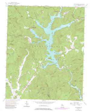
Lake Burton Topo Map Georgia
To zoom in, hover over the map of Lake Burton
USGS Topo Quad 34083g5 - 1:24,000 scale
| Topo Map Name: | Lake Burton |
| USGS Topo Quad ID: | 34083g5 |
| Print Size: | ca. 21 1/4" wide x 27" high |
| Southeast Coordinates: | 34.75° N latitude / 83.5° W longitude |
| Map Center Coordinates: | 34.8125° N latitude / 83.5625° W longitude |
| U.S. State: | GA |
| Filename: | o34083g5.jpg |
| Download Map JPG Image: | Lake Burton topo map 1:24,000 scale |
| Map Type: | Topographic |
| Topo Series: | 7.5´ |
| Map Scale: | 1:24,000 |
| Source of Map Images: | United States Geological Survey (USGS) |
| Alternate Map Versions: |
Lake Burton GA 1957 Download PDF Buy paper map Burton Lake GA 1957, updated 1958 Download PDF Buy paper map Lake Burton GA 1957, updated 1967 Download PDF Buy paper map Lake Burton GA 2011 Download PDF Buy paper map Lake Burton GA 2014 Download PDF Buy paper map |
| FStopo: | US Forest Service topo Lake Burton is available: Download FStopo PDF Download FStopo TIF |
1:24,000 Topo Quads surrounding Lake Burton
> Back to 34083e1 at 1:100,000 scale
> Back to 34082a1 at 1:250,000 scale
> Back to U.S. Topo Maps home
Lake Burton topo map: Gazetteer
Lake Burton: Airports
King Sky Ranch Airport elevation 553m 1814′Lake Burton: Bays
Cherokee Cove elevation 567m 1860′Dicks Creek Cove elevation 567m 1860′
Magness Cove elevation 567m 1860′
Mary Cove elevation 567m 1860′
Moccasin Creek Cove elevation 567m 1860′
Perrin Cove elevation 567m 1860′
Timpson Cove elevation 567m 1860′
Wildcat Creek Cove elevation 567m 1860′
Lake Burton: Dams
Dean Lake Dam elevation 748m 2454′High Valley Boys Club Lake Dam elevation 756m 2480′
Nacoochee Dam elevation 534m 1751′
Sportsman Club Dam elevation 572m 1876′
Lake Burton: Falls
Wilson Falls elevation 602m 1975′Lake Burton: Islands
Billy Goat Island elevation 573m 1879′Lake Burton: Parks
Lake Burton Game Management Area (historical) elevation 849m 2785′Moccasin Creek State Park elevation 579m 1899′
Lake Burton: Populated Places
Burton (historical) elevation 918m 3011′Wikle Store elevation 534m 1751′
Lake Burton: Post Offices
Burton Post Office (historical) elevation 567m 1860′Lake Burton: Reservoirs
Dean Lake elevation 748m 2454′High Valley Boys Club Lake elevation 756m 2480′
Lake Burton elevation 573m 1879′
Seed Lake elevation 535m 1755′
Sportsman Club Lake elevation 572m 1876′
Lake Burton: Ridges
Bramlet Ridge elevation 895m 2936′Dads Ridge elevation 791m 2595′
Long Ridge elevation 745m 2444′
Pigpen Ridge elevation 880m 2887′
Sawmill Ridge elevation 731m 2398′
Shoal Ridge elevation 713m 2339′
York Ridge elevation 849m 2785′
Lake Burton: Streams
Acorn Creek elevation 572m 1876′Bad Branch elevation 536m 1758′
Baker Branch elevation 709m 2326′
Bridge Creek elevation 534m 1751′
Canal Branch elevation 575m 1886′
Chastain Branch elevation 511m 1676′
Cliff Creek elevation 536m 1758′
Crow Creek elevation 534m 1751′
Dads Creek elevation 536m 1758′
Dickenson Branch elevation 571m 1873′
Dicks Creek elevation 567m 1860′
Gizzard Branch elevation 635m 2083′
Gomer Branch elevation 578m 1896′
Goshen Branch elevation 498m 1633′
Goshen Creek elevation 602m 1975′
Hellhole Branch elevation 701m 2299′
High Valley Branch elevation 721m 2365′
Horse Branch elevation 538m 1765′
Jessie Branch elevation 714m 2342′
Jones Branch elevation 571m 1873′
La Counts Creek elevation 535m 1755′
Left Fork Soquee River elevation 488m 1601′
Long Branch elevation 535m 1755′
Mill Creek elevation 571m 1873′
Moccasin Creek elevation 567m 1860′
North Fork Moccasin Creek elevation 786m 2578′
Right Fork Soquee River elevation 488m 1601′
Sawmill Creek elevation 542m 1778′
Seals Creek elevation 535m 1755′
Slick Shoal Creek elevation 536m 1758′
Soque Branch elevation 614m 2014′
South Fork Moccasin Creek elevation 780m 2559′
Timpson Creek elevation 570m 1870′
Wildcat Creek elevation 570m 1870′
Lake Burton: Summits
Charlie Mountain elevation 888m 2913′Crow Mountain elevation 758m 2486′
Falls Mountain elevation 928m 3044′
Glassy Mountain elevation 1046m 3431′
Goshen Mountain elevation 857m 2811′
Hellhole Mountain elevation 980m 3215′
Moates Knob elevation 706m 2316′
Muley Mountain elevation 990m 3248′
Pigeon Mountain elevation 711m 2332′
Raper Mountain elevation 691m 2267′
Lake Burton digital topo map on disk
Buy this Lake Burton topo map showing relief, roads, GPS coordinates and other geographical features, as a high-resolution digital map file on DVD:
South Carolina, Western North Carolina & Northeastern Georgia
Buy digital topo maps: South Carolina, Western North Carolina & Northeastern Georgia


