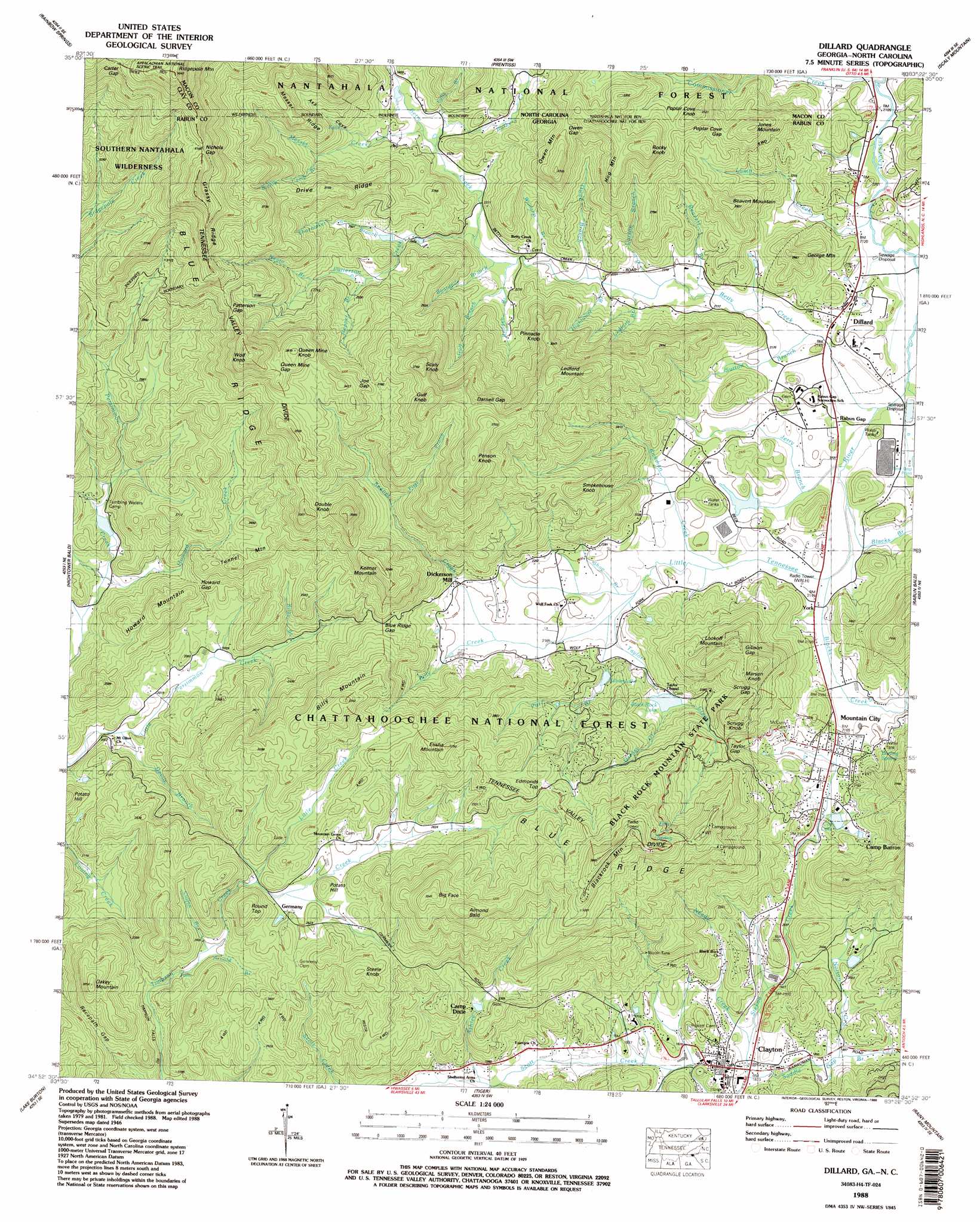
Dillard Topo Map Georgia
To zoom in, hover over the map of Dillard
USGS Topo Quad 34083h4 - 1:24,000 scale
| Topo Map Name: | Dillard |
| USGS Topo Quad ID: | 34083h4 |
| Print Size: | ca. 21 1/4" wide x 27" high |
| Southeast Coordinates: | 34.875° N latitude / 83.375° W longitude |
| Map Center Coordinates: | 34.9375° N latitude / 83.4375° W longitude |
| U.S. States: | GA, NC |
| Filename: | o34083h4.jpg |
| Download Map JPG Image: | Dillard topo map 1:24,000 scale |
| Map Type: | Topographic |
| Topo Series: | 7.5´ |
| Map Scale: | 1:24,000 |
| Source of Map Images: | United States Geological Survey (USGS) |
| Alternate Map Versions: |
Dillard GA 1935 Download PDF Buy paper map Dillard GA 1946, updated 1956 Download PDF Buy paper map Dillard GA 1946, updated 1965 Download PDF Buy paper map Dillard GA 1946, updated 1971 Download PDF Buy paper map Dillard GA 1946, updated 1977 Download PDF Buy paper map Dillard GA 1947, updated 1947 Download PDF Buy paper map Dillard GA 1988, updated 1988 Download PDF Buy paper map Dillard GA 2011 Download PDF Buy paper map Dillard GA 2014 Download PDF Buy paper map |
| FStopo: | US Forest Service topo Dillard is available: Download FStopo PDF Download FStopo TIF |
1:24,000 Topo Quads surrounding Dillard
Topton |
Wayah Bald |
Franklin |
Corbin Knob |
Glenville |
Shooting Creek |
Rainbow Springs |
Prentiss |
Scaly Mountain |
Highlands |
Macedonia |
Hightower Bald |
Dillard |
Rabun Bald |
Satolah |
Tray Mountain |
Lake Burton |
Tiger |
Rainy Mountain |
Whetstone |
Helen |
Clarkesville Ne |
Tallulah Falls |
Tugaloo Lake |
Holly Springs |
> Back to 34083e1 at 1:100,000 scale
> Back to 34082a1 at 1:250,000 scale
> Back to U.S. Topo Maps home
Dillard topo map: Gazetteer
Dillard: Dams
Black Rock Lake Dam elevation 688m 2257′Cox Lake Dam elevation 655m 2148′
Rabun Gap Nacoochee School Lake Dam elevation 657m 2155′
Rabun School Dam elevation 648m 2125′
Rogers-Sale Lake Dam elevation 642m 2106′
Dillard: Falls
Timpson Falls elevation 716m 2349′Dillard: Gaps
Blue Ridge Gap elevation 776m 2545′Carter Gap elevation 1381m 4530′
Darnell Gap elevation 1047m 3435′
Gibson Gap elevation 908m 2979′
Howard Gap elevation 712m 2335′
Joe Gap elevation 1053m 3454′
Nichols Gap elevation 1271m 4169′
Owen Gap elevation 910m 2985′
Patterson Gap elevation 1013m 3323′
Poplar Cove Gap elevation 844m 2769′
Queen Mine Gap elevation 1070m 3510′
Rabun Gap elevation 657m 2155′
Racepath Gap elevation 766m 2513′
Scrugg Gap elevation 885m 2903′
Taylor Gap elevation 797m 2614′
Wolf Fork Gap elevation 827m 2713′
Dillard: Lakes
Black Rock Lake elevation 688m 2257′Dillard: Mines
Moore Girls Mine elevation 632m 2073′Dillard: Parks
Bettys Creek Recreation Area elevation 713m 2339′Black Rock Mountain State Park elevation 997m 3270′
Coleman River Wildlife Management Area elevation 825m 2706′
Hambidge Center Historic District elevation 708m 2322′
Standing Indian Wildlife Management Area elevation 1089m 3572′
Dillard: Populated Places
Clayton elevation 588m 1929′Dickerson Mill elevation 695m 2280′
Dillard elevation 660m 2165′
Germany elevation 792m 2598′
Kilby Mill elevation 655m 2148′
Mountain City elevation 657m 2155′
York elevation 653m 2142′
Dillard: Reservoirs
Cox Lake elevation 655m 2148′Rabun Gap Nacoochee School Lake elevation 657m 2155′
Rogers-Sale Lake elevation 642m 2106′
Silvan Lake elevation 686m 2250′
Dillard: Ridges
Drive Ridge elevation 952m 3123′Grassy Ridge elevation 1244m 4081′
Hogback elevation 815m 2673′
Messer Ridge elevation 1021m 3349′
Messer Ridge elevation 1018m 3339′
Dillard: Springs
Darling Spring elevation 682m 2237′Dillard: Streams
Arnold Branch elevation 723m 2372′Ashley Creek elevation 584m 1916′
Barkers Creek elevation 702m 2303′
Barkers Creek elevation 702m 2303′
Beavert Branch elevation 656m 2152′
Betty Creek elevation 645m 2116′
Betty Creek elevation 642m 2106′
Billy Creek elevation 664m 2178′
Blacks Branch elevation 645m 2116′
Blacks Creek elevation 646m 2119′
Boardpile Branch elevation 678m 2224′
Carson Branch elevation 660m 2165′
Coffee Branch elevation 727m 2385′
Commissioner Creek elevation 637m 2089′
Darnell Creek elevation 645m 2116′
Devils Branch elevation 601m 1971′
Double Branch elevation 656m 2152′
Double Branch elevation 662m 2171′
Falls Branch elevation 703m 2306′
Falls Branch elevation 703m 2306′
First Prong elevation 800m 2624′
Greasy Creek elevation 688m 2257′
Gulf Branch elevation 676m 2217′
Hightower Branch elevation 665m 2181′
Hopper Branch elevation 764m 2506′
Howard Creek elevation 619m 2030′
Jerry Branch elevation 644m 2112′
Keener Branch elevation 612m 2007′
Keener Creek elevation 664m 2178′
Kilby Branch elevation 643m 2109′
Lamb Creek elevation 638m 2093′
Ledford Branch elevation 662m 2171′
Little Creek elevation 780m 2559′
Messer Creek elevation 707m 2319′
Messer Creek elevation 706m 2316′
Mud Creek elevation 642m 2106′
Needy Creek elevation 571m 1873′
Negro Branch elevation 789m 2588′
Norton Creek elevation 579m 1899′
Owen Branch elevation 666m 2185′
Patterson Creek elevation 683m 2240′
Pitt Branch elevation 656m 2152′
Redden Branch elevation 685m 2247′
Richie Camp Branch elevation 775m 2542′
Rickman Creek elevation 651m 2135′
Saddle Gap Branch elevation 569m 1866′
Shoemaker Branch elevation 740m 2427′
Shop Branch elevation 655m 2148′
Sutton Branch elevation 648m 2125′
Taylor Creek elevation 655m 2148′
Williams Branch elevation 669m 2194′
Dillard: Summits
Beavert Mountain elevation 853m 2798′Big Face elevation 1077m 3533′
Billy Mountain elevation 990m 3248′
Blackrock Mountain elevation 1108m 3635′
Cedar Knob elevation 1077m 3533′
Double Knob elevation 1016m 3333′
Edmonds Top elevation 892m 2926′
Elisha Mountain elevation 989m 3244′
George Mountain elevation 819m 2687′
Gulf Knob elevation 1151m 3776′
Hog Mountain elevation 955m 3133′
Howard Mountain elevation 805m 2641′
Jones Mountain elevation 918m 3011′
Keener Mountain elevation 978m 3208′
Ledford Mountain elevation 1053m 3454′
Lookoff Mountain elevation 933m 3061′
Marsen Knob elevation 971m 3185′
Oakey Mountain elevation 931m 3054′
Owen Mountain elevation 966m 3169′
Penson Knob elevation 1153m 3782′
Pinnacle Knob elevation 927m 3041′
Poplar Cove Knob elevation 951m 3120′
Potato Hill elevation 841m 2759′
Queen Mine Knob elevation 1101m 3612′
Ridgepole Mountain elevation 1525m 5003′
Rocky Knob elevation 1009m 3310′
Round Top elevation 903m 2962′
Scaly Knob elevation 1138m 3733′
Scrugg Knob elevation 928m 3044′
Smokehouse Knob elevation 968m 3175′
Steele Knob elevation 915m 3001′
Tunnel Mountain elevation 824m 2703′
Wolf Knob elevation 1209m 3966′
Dillard: Valleys
Asa Cove elevation 724m 2375′Poplar Cove elevation 723m 2372′
Poplar Cove elevation 719m 2358′
Dillard digital topo map on disk
Buy this Dillard topo map showing relief, roads, GPS coordinates and other geographical features, as a high-resolution digital map file on DVD:
South Carolina, Western North Carolina & Northeastern Georgia
Buy digital topo maps: South Carolina, Western North Carolina & Northeastern Georgia