Birmingham Topo Map Georgia
To zoom in, hover over the map of Birmingham
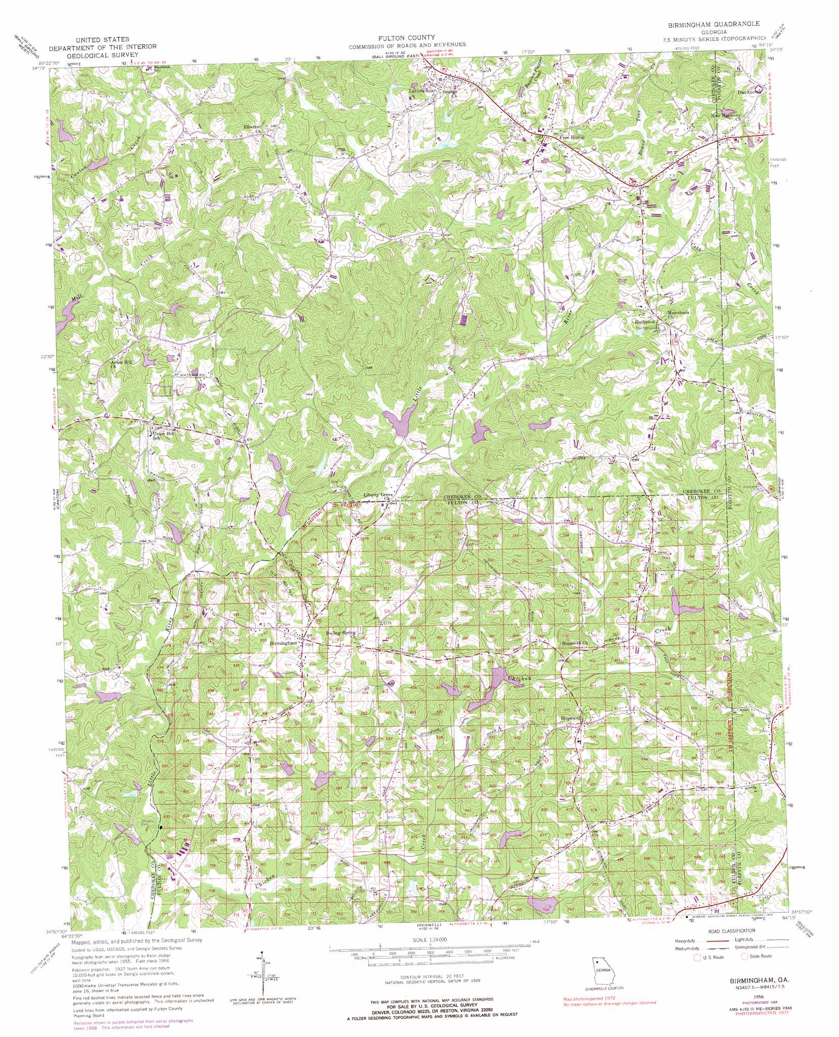
USGS Topo Quad 34084b3 - 1:24,000 scale
| Topo Map Name: | Birmingham |
| USGS Topo Quad ID: | 34084b3 |
| Print Size: | ca. 21 1/4" wide x 27" high |
| Southeast Coordinates: | 34.125° N latitude / 84.25° W longitude |
| Map Center Coordinates: | 34.1875° N latitude / 84.3125° W longitude |
| U.S. State: | GA |
| Filename: | o34084b3.jpg |
| Download Map JPG Image: | Birmingham topo map 1:24,000 scale |
| Map Type: | Topographic |
| Topo Series: | 7.5´ |
| Map Scale: | 1:24,000 |
| Source of Map Images: | United States Geological Survey (USGS) |
| Alternate Map Versions: |
Birmingham GA 1956, updated 1957 Download PDF Buy paper map Birmingham GA 1956, updated 1968 Download PDF Buy paper map Birmingham GA 1956, updated 1969 Download PDF Buy paper map Birmingham GA 1956, updated 1976 Download PDF Buy paper map Birmingham GA 2011 Download PDF Buy paper map Birmingham GA 2014 Download PDF Buy paper map |
1:24,000 Topo Quads surrounding Birmingham
Ludville |
Jasper |
Nelson |
Juno |
Dawsonville |
Waleska |
Ball Ground West |
Ball Ground East |
Matt |
Coal Mountain |
South Canton |
Canton |
Birmingham |
Cumming |
Buford Dam |
Kennesaw |
Mountain Park |
Roswell |
Duluth |
Suwanee |
Marietta |
Sandy Springs |
Chamblee |
Norcross |
Luxomni |
> Back to 34084a1 at 1:100,000 scale
> Back to 34084a1 at 1:250,000 scale
> Back to U.S. Topo Maps home
Birmingham topo map: Gazetteer
Birmingham: Dams
Beaver Lake Dam elevation 330m 1082′Beck Lake Dam elevation 326m 1069′
Bell 24 Dam elevation 293m 961′
Bryon Dam elevation 324m 1062′
Canton Creek Lake Dam elevation 331m 1085′
Freedrick Lake Dam elevation 304m 997′
King Dam elevation 298m 977′
Little River Structure Number 13 Dam elevation 284m 931′
Little River-Coosa River Dam Number 22 elevation 311m 1020′
Little River-Coosa River Watershed Dam Number 15 elevation 298m 977′
Little River-Coosa River Watershed Dam Number 17 elevation 297m 974′
Little River-Coosa River Watershed Dam Number 19 elevation 308m 1010′
Little River-Coosa River Watershed Dam Number 21 elevation 307m 1007′
Sargent Dam elevation 302m 990′
Seagraves Dam elevation 306m 1003′
Starnes Dam elevation 297m 974′
Thurmond Lake Dam elevation 315m 1033′
Westbrook Dam elevation 370m 1213′
Birmingham: Parks
Bell Memorial Park elevation 331m 1085′Birmingham Park elevation 312m 1023′
Birmingham: Populated Places
Alpharetta Woods elevation 334m 1095′Bentgrass Farms elevation 321m 1053′
Birmingham elevation 324m 1062′
Birmingham Road Estates elevation 308m 1010′
Christophers Run elevation 318m 1043′
Country Ridge elevation 325m 1066′
Five Acres Estates elevation 340m 1115′
Free Home elevation 382m 1253′
Henderson Heights elevation 338m 1108′
Hidden Valley Farms elevation 302m 990′
Holbrook elevation 370m 1213′
Hopewell elevation 342m 1122′
Knox Landing elevation 320m 1049′
Lathemtown elevation 372m 1220′
Laurel Grove elevation 335m 1099′
Milton elevation 299m 980′
North Valley elevation 313m 1026′
Rollingwood Mobile Home Park elevation 354m 1161′
Sunnybrook Farms elevation 298m 977′
Tullamore elevation 343m 1125′
Wood Valley elevation 312m 1023′
Wyndham Farms elevation 342m 1122′
Birmingham: Reservoirs
Almond Lake elevation 307m 1007′Beaver Lake elevation 330m 1082′
Beck Lake elevation 326m 1069′
Bell Lake elevation 293m 961′
Bryon Lake elevation 324m 1062′
Canton Creek Lake elevation 331m 1085′
Fredrick Lake elevation 304m 997′
King Lake elevation 298m 977′
Michael Lake elevation 298m 977′
Reece Lake elevation 284m 931′
Sargent Lake elevation 302m 990′
Seagraves Lake elevation 306m 1003′
Shell Lake elevation 308m 1010′
Starnes Lake elevation 297m 974′
Statham Lake elevation 297m 974′
Stephens Lake elevation 311m 1020′
Thurmond Lake elevation 315m 1033′
Westbrook Lake elevation 370m 1213′
Birmingham digital topo map on disk
Buy this Birmingham topo map showing relief, roads, GPS coordinates and other geographical features, as a high-resolution digital map file on DVD: