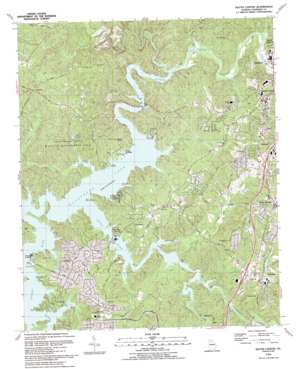
South Canton Topo Map Georgia
To zoom in, hover over the map of South Canton
USGS Topo Quad 34084b5 - 1:24,000 scale
| Topo Map Name: | South Canton |
| USGS Topo Quad ID: | 34084b5 |
| Print Size: | ca. 21 1/4" wide x 27" high |
| Southeast Coordinates: | 34.125° N latitude / 84.5° W longitude |
| Map Center Coordinates: | 34.1875° N latitude / 84.5625° W longitude |
| U.S. State: | GA |
| Filename: | o34084b5.jpg |
| Download Map JPG Image: | South Canton topo map 1:24,000 scale |
| Map Type: | Topographic |
| Topo Series: | 7.5´ |
| Map Scale: | 1:24,000 |
| Source of Map Images: | United States Geological Survey (USGS) |
| Alternate Map Versions: |
South Canton GA 1961, updated 1963 Download PDF Buy paper map South Canton GA 1961, updated 1969 Download PDF Buy paper map South Canton GA 1961, updated 1975 Download PDF Buy paper map South Canton GA 1961, updated 1986 Download PDF Buy paper map South Canton GA 1993, updated 1993 Download PDF Buy paper map South Canton GA 1997, updated 1999 Download PDF Buy paper map South Canton GA 2011 Download PDF Buy paper map South Canton GA 2014 Download PDF Buy paper map |
1:24,000 Topo Quads surrounding South Canton
> Back to 34084a1 at 1:100,000 scale
> Back to 34084a1 at 1:250,000 scale
> Back to U.S. Topo Maps home
South Canton topo map: Gazetteer
South Canton: Bridges
Knox Bridge elevation 257m 843′Little River Bridge elevation 256m 839′
South Canton: Dams
Ellison Lake Dam elevation 277m 908′Greene Lake Dam elevation 306m 1003′
McDaniel Lake Dam elevation 300m 984′
South Canton: Mines
Cherokee Mine elevation 294m 964′Clarkston Mine elevation 315m 1033′
Downing Creek Placer Mine elevation 277m 908′
Macou Prospect elevation 329m 1079′
Putnam Mine elevation 285m 935′
Sixes Mine elevation 295m 967′
Three Hundred and One Mine elevation 307m 1007′
South Canton: Parks
Boling Park elevation 261m 856′Cherokee County Park elevation 272m 892′
Cushing Memorial Park (historical) elevation 275m 902′
Hobgood Park elevation 296m 971′
Lake Allatoona Managed Hunting Area elevation 310m 1017′
South Canton: Populated Places
Cherokee elevation 269m 882′Fields Landing elevation 256m 839′
Holly Springs elevation 338m 1108′
Lebanon elevation 305m 1000′
Little River Landing elevation 259m 849′
South Canton elevation 325m 1066′
Sutallee elevation 338m 1108′
Univeter elevation 326m 1069′
Victoria elevation 275m 902′
Victoria Landing elevation 256m 839′
South Canton: Reservoirs
Ellison Lake elevation 277m 908′Greene Lake elevation 306m 1003′
McDaniel Lake elevation 300m 984′
South Canton: Streams
Blankets Creek elevation 256m 839′Downing Creek elevation 256m 839′
Jug Creek elevation 258m 846′
Kellogg Creek elevation 256m 839′
Knox Creek elevation 256m 839′
Little River elevation 257m 843′
Little Shoal Creek elevation 267m 875′
Noonday Creek elevation 256m 839′
Owl Creek elevation 256m 839′
Puckett Creek elevation 260m 853′
Rose Creek elevation 256m 839′
Shoal Creek elevation 256m 839′
Sweetwater Creek elevation 256m 839′
Toonigh Creek elevation 256m 839′
South Canton digital topo map on disk
Buy this South Canton topo map showing relief, roads, GPS coordinates and other geographical features, as a high-resolution digital map file on DVD:


