Ball Ground West Topo Map Georgia
To zoom in, hover over the map of Ball Ground West
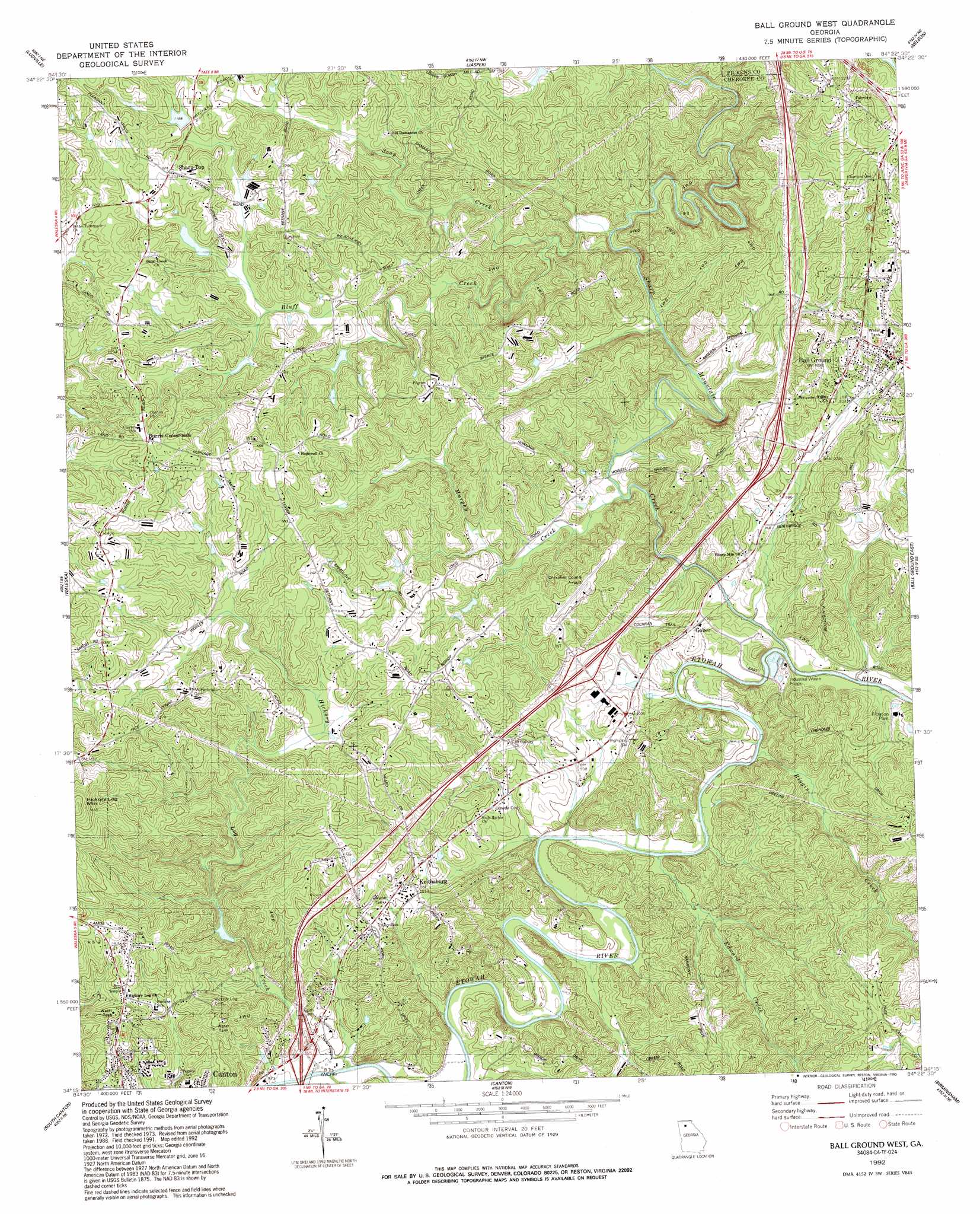
USGS Topo Quad 34084c4 - 1:24,000 scale
| Topo Map Name: | Ball Ground West |
| USGS Topo Quad ID: | 34084c4 |
| Print Size: | ca. 21 1/4" wide x 27" high |
| Southeast Coordinates: | 34.25° N latitude / 84.375° W longitude |
| Map Center Coordinates: | 34.3125° N latitude / 84.4375° W longitude |
| U.S. State: | GA |
| Filename: | o34084c4.jpg |
| Download Map JPG Image: | Ball Ground West topo map 1:24,000 scale |
| Map Type: | Topographic |
| Topo Series: | 7.5´ |
| Map Scale: | 1:24,000 |
| Source of Map Images: | United States Geological Survey (USGS) |
| Alternate Map Versions: |
Ball Ground West GA 1973, updated 1975 Download PDF Buy paper map Ball Ground West GA 1973, updated 1984 Download PDF Buy paper map Ball Ground West GA 1973, updated 1986 Download PDF Buy paper map Ball Ground West GA 1992, updated 1993 Download PDF Buy paper map Ball Ground West GA 1997, updated 1999 Download PDF Buy paper map Ball Ground West GA 2011 Download PDF Buy paper map Ball Ground West GA 2014 Download PDF Buy paper map |
1:24,000 Topo Quads surrounding Ball Ground West
Oakman |
Talking Rock |
Dyke |
Amicalola |
Nimblewill |
Fairmount |
Ludville |
Jasper |
Nelson |
Juno |
White East |
Waleska |
Ball Ground West |
Ball Ground East |
Matt |
Allatoona Dam |
South Canton |
Canton |
Birmingham |
Cumming |
Acworth |
Kennesaw |
Mountain Park |
Roswell |
Duluth |
> Back to 34084a1 at 1:100,000 scale
> Back to 34084a1 at 1:250,000 scale
> Back to U.S. Topo Maps home
Ball Ground West topo map: Gazetteer
Ball Ground West: Airports
Cherokee County Airport elevation 371m 1217′Pegasus Run Airport elevation 285m 935′
Ball Ground West: Dams
Canton Mills Lake Dam elevation 284m 931′Ford Lake Dam elevation 341m 1118′
Sharp Mountain Creek Structure Number Five Dam elevation 356m 1167′
Sharp Mountain Creek Structure Number Seven Dam elevation 365m 1197′
Sharp Mountain Creek Structure Number Six Dam elevation 362m 1187′
Ball Ground West: Populated Places
Ball Ground elevation 336m 1102′Burris Crossroads elevation 408m 1338′
Gober elevation 293m 961′
Keithsburg elevation 316m 1036′
Sharp Top elevation 378m 1240′
Ball Ground West: Post Offices
Ball Ground Post Office elevation 336m 1102′Ball Ground West: Reservoirs
Canton Mills Lake elevation 284m 931′Ford Lake elevation 341m 1118′
Moore Lake elevation 362m 1187′
Payne-Smith Lake elevation 365m 1197′
Turner Lake elevation 356m 1167′
Ball Ground West: Streams
Bluff Creek elevation 298m 977′Edward Creek elevation 269m 882′
Hickory Log Creek elevation 263m 862′
Murphy Creek elevation 280m 918′
Riggin Creek elevation 270m 885′
Sharp Mountain Creek elevation 274m 898′
Soap Creek elevation 299m 980′
Ball Ground West digital topo map on disk
Buy this Ball Ground West topo map showing relief, roads, GPS coordinates and other geographical features, as a high-resolution digital map file on DVD: