Fairmount Topo Map Georgia
To zoom in, hover over the map of Fairmount
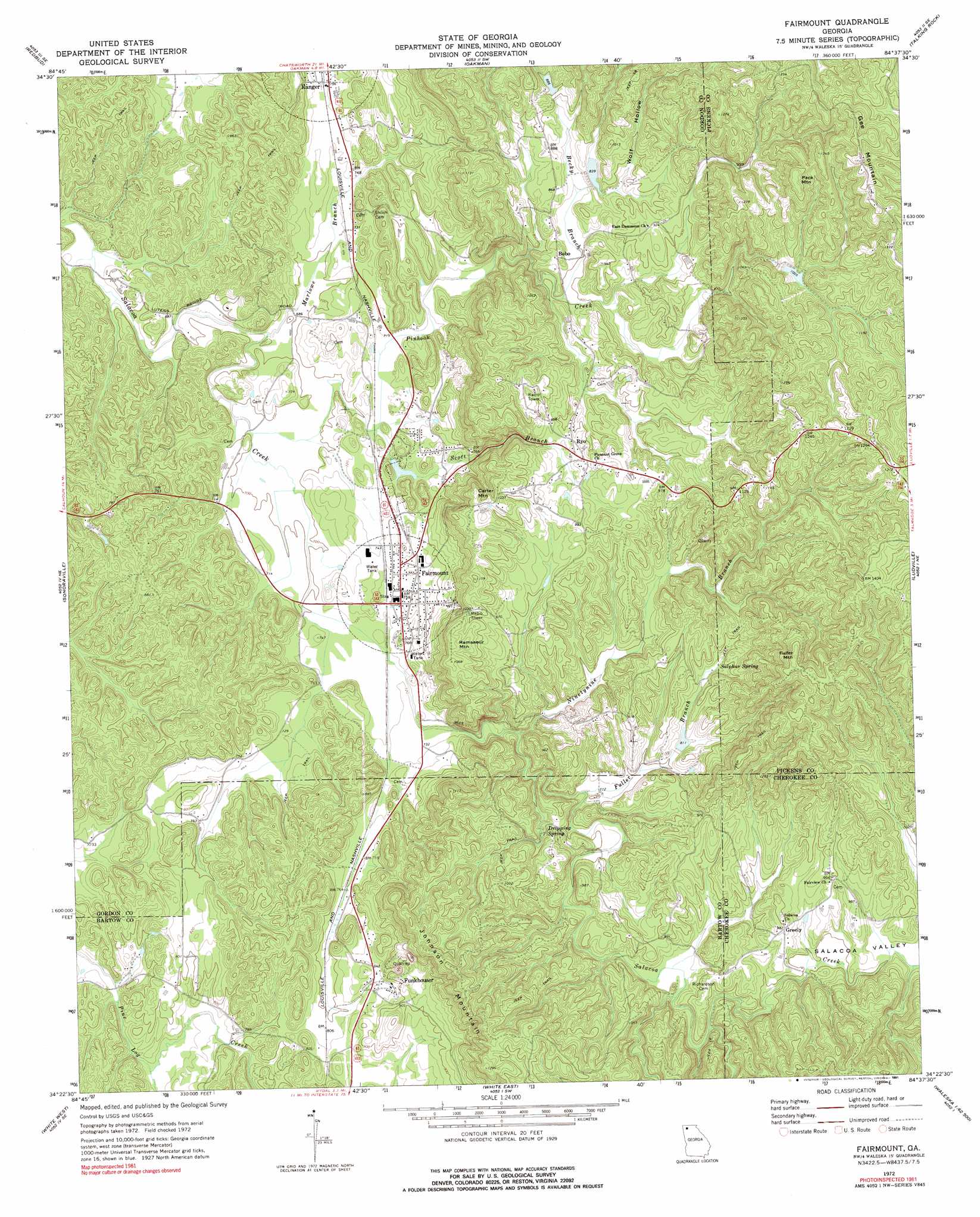
USGS Topo Quad 34084d6 - 1:24,000 scale
| Topo Map Name: | Fairmount |
| USGS Topo Quad ID: | 34084d6 |
| Print Size: | ca. 21 1/4" wide x 27" high |
| Southeast Coordinates: | 34.375° N latitude / 84.625° W longitude |
| Map Center Coordinates: | 34.4375° N latitude / 84.6875° W longitude |
| U.S. State: | GA |
| Filename: | o34084d6.jpg |
| Download Map JPG Image: | Fairmount topo map 1:24,000 scale |
| Map Type: | Topographic |
| Topo Series: | 7.5´ |
| Map Scale: | 1:24,000 |
| Source of Map Images: | United States Geological Survey (USGS) |
| Alternate Map Versions: |
Fairmount GA 1972, updated 1974 Download PDF Buy paper map Fairmount GA 1972, updated 1991 Download PDF Buy paper map Fairmount GA 2011 Download PDF Buy paper map Fairmount GA 2014 Download PDF Buy paper map |
1:24,000 Topo Quads surrounding Fairmount
Dalton South |
Calhoun Ne |
Ramhurst |
Webb |
Ellijay |
Calhoun North |
Redbud |
Oakman |
Talking Rock |
Dyke |
Calhoun South |
Sonoraville |
Fairmount |
Ludville |
Jasper |
Adairsville |
White West |
White East |
Waleska |
Ball Ground West |
Kingston |
Cartersville |
Allatoona Dam |
South Canton |
Canton |
> Back to 34084a1 at 1:100,000 scale
> Back to 34084a1 at 1:250,000 scale
> Back to U.S. Topo Maps home
Fairmount topo map: Gazetteer
Fairmount: Dams
Salacoa Creek Watershed Dam Number 100 elevation 258m 846′Salacoa Creek Watershed Dam Number 67 elevation 249m 816′
Sallacoa Creek Watershed Dam Number 89 elevation 250m 820′
Sallacoa Creek Watershed Number 99 Dam elevation 272m 892′
Sallacoa Watershed Dam Number 48 elevation 310m 1017′
Takila Lake Dam elevation 224m 734′
Fairmount: Populated Places
Bobo elevation 251m 823′Fairmount elevation 227m 744′
Funkhouser elevation 277m 908′
Greely elevation 300m 984′
Igo (historical) elevation 227m 744′
Ryo elevation 285m 935′
Fairmount: Post Offices
Fairmount Post Office elevation 230m 754′Ranger Post Office elevation 231m 757′
Fairmount: Reservoirs
Anderson Lake elevation 310m 1017′Brannon Lake elevation 250m 820′
Jones Lake elevation 258m 846′
Patterson Lake elevation 249m 816′
Takila Lake elevation 224m 734′
Fairmount: Springs
Dripping Spring elevation 272m 892′Sulphur Spring elevation 261m 856′
Fairmount: Streams
Becky Branch elevation 244m 800′Fuller Branch elevation 225m 738′
Marlowe Branch elevation 207m 679′
Ninetynine Branch elevation 213m 698′
Pinhook Creek elevation 210m 688′
Scott Branch elevation 219m 718′
Fairmount: Summits
Carter Mountain elevation 322m 1056′Fuller Mountain elevation 397m 1302′
Gee Mountain elevation 420m 1377′
Johnson Mountain elevation 381m 1250′
Pack Mountain elevation 403m 1322′
Ramsaeur Mountain elevation 329m 1079′
Fairmount: Valleys
Calico Valley elevation 225m 738′Salacoa Valley elevation 272m 892′
Wolf Hollow elevation 262m 859′
Fairmount digital topo map on disk
Buy this Fairmount topo map showing relief, roads, GPS coordinates and other geographical features, as a high-resolution digital map file on DVD: