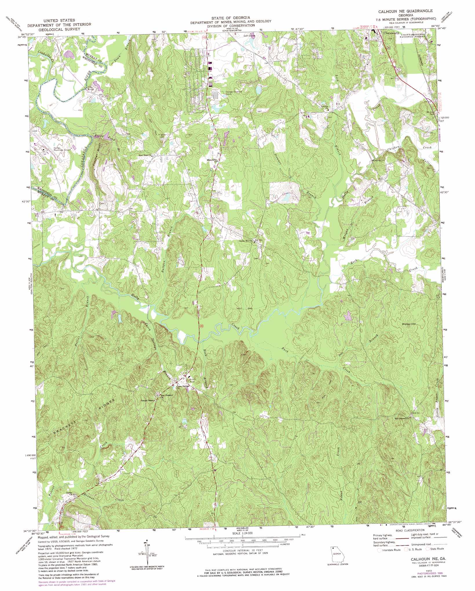
Calhoun Ne Topo Map Georgia
To zoom in, hover over the map of Calhoun Ne
USGS Topo Quad 34084f7 - 1:24,000 scale
| Topo Map Name: | Calhoun Ne |
| USGS Topo Quad ID: | 34084f7 |
| Print Size: | ca. 21 1/4" wide x 27" high |
| Southeast Coordinates: | 34.625° N latitude / 84.75° W longitude |
| Map Center Coordinates: | 34.6875° N latitude / 84.8125° W longitude |
| U.S. State: | GA |
| Filename: | o34084f7.jpg |
| Download Map JPG Image: | Calhoun Ne topo map 1:24,000 scale |
| Map Type: | Topographic |
| Topo Series: | 7.5´ |
| Map Scale: | 1:24,000 |
| Source of Map Images: | United States Geological Survey (USGS) |
| Alternate Map Versions: |
Calhoun NE GA 1972, updated 1974 Download PDF Buy paper map Calhoun NE GA 1972, updated 1986 Download PDF Buy paper map Calhoun NE GA 2011 Download PDF Buy paper map Calhoun NE GA 2014 Download PDF Buy paper map |
| FStopo: | US Forest Service topo Calhoun NE is available: Download FStopo PDF Download FStopo TIF |
1:24,000 Topo Quads surrounding Calhoun Ne
Ringgold |
Cohutta |
Beaverdale |
Tennga |
Hemp Top |
Tunnel Hill |
Dalton North |
Chatsworth |
Crandall |
Dyer Gap |
Villanow |
Dalton South |
Calhoun Ne |
Ramhurst |
Webb |
Sugar Valley |
Calhoun North |
Redbud |
Oakman |
Talking Rock |
Plainville |
Calhoun South |
Sonoraville |
Fairmount |
Ludville |
> Back to 34084e1 at 1:100,000 scale
> Back to 34084a1 at 1:250,000 scale
> Back to U.S. Topo Maps home
Calhoun Ne topo map: Gazetteer
Calhoun Ne: Airports
Dalton Municipal Airport elevation 214m 702′Calhoun Ne: Bridges
Browns Bridge elevation 197m 646′Tibbs Bridge elevation 201m 659′
Calhoun Ne: Cliffs
Fincher Bluff elevation 227m 744′Calhoun Ne: Crossings
Smoke Ford elevation 198m 649′Calhoun Ne: Dams
Brindle Lake Dam elevation 240m 787′Mashburn Lake East Dam elevation 210m 688′
Nashburn Lake West Dam elevation 220m 721′
Calhoun Ne: Populated Places
Ball Ground elevation 228m 748′Holley elevation 221m 725′
Wells (historical) elevation 214m 702′
Calhoun Ne: Reservoirs
Brindle Lake elevation 240m 787′Mashburn Lake East elevation 210m 688′
Mashburn Lake West elevation 220m 721′
Calhoun Ne: Ridges
Brackett Ridges elevation 228m 748′Calhoun Ne: Streams
Beamer Creek elevation 202m 662′Buck Creek elevation 206m 675′
Bullpen Branch elevation 202m 662′
Casey Springs Branch elevation 202m 662′
Chicken Creek elevation 212m 695′
Coahulla Creek elevation 200m 656′
Doe Branch elevation 209m 685′
Lick Branch elevation 209m 685′
Pettiet Branch elevation 201m 659′
Rock Branch elevation 204m 669′
Rock Creek elevation 207m 679′
Rocky Ford Branch elevation 198m 649′
Stewart Branch elevation 209m 685′
Town Branch elevation 201m 659′
Wright Branch elevation 208m 682′
Yellow Creek elevation 216m 708′
Calhoun Ne: Summits
Ridley Hill elevation 242m 793′Calhoun Ne digital topo map on disk
Buy this Calhoun Ne topo map showing relief, roads, GPS coordinates and other geographical features, as a high-resolution digital map file on DVD: