Blue Ridge Topo Map Georgia
To zoom in, hover over the map of Blue Ridge
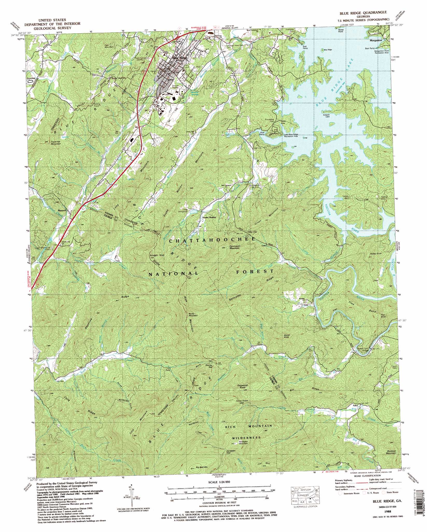
USGS Topo Quad 34084g3 - 1:24,000 scale
| Topo Map Name: | Blue Ridge |
| USGS Topo Quad ID: | 34084g3 |
| Print Size: | ca. 21 1/4" wide x 27" high |
| Southeast Coordinates: | 34.75° N latitude / 84.25° W longitude |
| Map Center Coordinates: | 34.8125° N latitude / 84.3125° W longitude |
| U.S. State: | GA |
| Filename: | o34084g3.jpg |
| Download Map JPG Image: | Blue Ridge topo map 1:24,000 scale |
| Map Type: | Topographic |
| Topo Series: | 7.5´ |
| Map Scale: | 1:24,000 |
| Source of Map Images: | United States Geological Survey (USGS) |
| Alternate Map Versions: |
Lake Toccoa GA 1935 Download PDF Buy paper map Blue Ridge GA 1946, updated 1960 Download PDF Buy paper map Blue Ridge GA 1946, updated 1965 Download PDF Buy paper map Blue Ridge GA 1946, updated 1975 Download PDF Buy paper map Lake Toccoa GA 1947, updated 1947 Download PDF Buy paper map Blue Ridge GA 1988, updated 1988 Download PDF Buy paper map Blue Ridge GA 2011 Download PDF Buy paper map Blue Ridge GA 2014 Download PDF Buy paper map |
| FStopo: | US Forest Service topo Blue Ridge is available: Download FStopo PDF Download FStopo TIF |
1:24,000 Topo Quads surrounding Blue Ridge
Caney Creek |
Ducktown |
Isabella |
Persimmon Creek |
Murphy |
Hemp Top |
Epworth |
Mineral Bluff |
Culberson |
Nottely Dam |
Dyer Gap |
Cashes Valley |
Blue Ridge |
Wilscot |
Mulky Gap |
Webb |
Ellijay |
Tickanetley |
Noontootla |
Suches |
Talking Rock |
Dyke |
Amicalola |
Nimblewill |
Campbell Mountain |
> Back to 34084e1 at 1:100,000 scale
> Back to 34084a1 at 1:250,000 scale
> Back to U.S. Topo Maps home
Blue Ridge topo map: Gazetteer
Blue Ridge: Bends
Free Bend elevation 604m 1981′Blue Ridge: Bridges
Shallow Ford Bridge elevation 535m 1755′Blue Ridge: Crossings
Shallow Ford elevation 536m 1758′Blue Ridge: Dams
Ellijay River Watershed Dam Number 11 elevation 508m 1666′Ellijay River Watershed Dam Number 12 elevation 563m 1847′
Gaeta Lake Dam elevation 549m 1801′
Blue Ridge: Gaps
Bullen Gap elevation 572m 1876′Deep Gap elevation 680m 2230′
Horsepen Gap elevation 1037m 3402′
Indian Grave Gap elevation 794m 2604′
Stanley Gap elevation 705m 2312′
Blue Ridge: Parks
Blue Ridge Lake Recreation Area elevation 537m 1761′Morganton Point Recreation Area elevation 523m 1715′
Blue Ridge: Populated Places
Aska elevation 579m 1899′Ballew Mill elevation 488m 1601′
Blue Ridge elevation 537m 1761′
Due (historical) elevation 576m 1889′
Elrod Mill elevation 507m 1663′
Greens Mill elevation 522m 1712′
Maxwell elevation 496m 1627′
Stewart Mill elevation 589m 1932′
Blue Ridge: Post Offices
Blue Ridge Post Office elevation 524m 1719′Blue Ridge: Ranges
Rich Mountain elevation 934m 3064′Blue Ridge: Reservoirs
Gaeta Lake elevation 549m 1801′Laurel Creek Lake elevation 563m 1847′
Sisson Lake elevation 508m 1666′
Blue Ridge: Ridges
Bellcamp Ridge elevation 855m 2805′Bill Ridge elevation 681m 2234′
Deadline Ridge elevation 769m 2522′
Long Ridge elevation 676m 2217′
Blue Ridge: Springs
Mineral Springs elevation 519m 1702′Blue Ridge: Streams
Big Branch elevation 557m 1827′Bream Branch elevation 525m 1722′
Charlie Creek elevation 533m 1748′
Fall Branch elevation 625m 2050′
Flat Creek elevation 534m 1751′
Laurel Creek elevation 471m 1545′
Little Creek elevation 582m 1909′
Long Branch elevation 530m 1738′
Mineral Springs Creek elevation 491m 1610′
Sisson Creek elevation 485m 1591′
Stanley Creek elevation 538m 1765′
Stillhouse Creek elevation 573m 1879′
Trammel Branch elevation 485m 1591′
Turnpike Branch elevation 495m 1624′
Wolf Branch elevation 600m 1968′
Wolf Creek elevation 726m 2381′
Blue Ridge: Summits
Big Bald Mountain elevation 1235m 4051′Buckeye Mountain elevation 746m 2447′
Cold Mountain elevation 1165m 3822′
Davenport Mountain elevation 904m 2965′
Dogwood Knob elevation 893m 2929′
Fain Mountain elevation 630m 2066′
Free Knob elevation 695m 2280′
Green Mountain elevation 757m 2483′
Hickey Knob elevation 680m 2230′
Horsepen Mountain elevation 1069m 3507′
Joel Mountain elevation 1015m 3330′
Long Mountain elevation 662m 2171′
Rocky Mountain elevation 1052m 3451′
Scroggin Knob elevation 829m 2719′
Snake Nation Mountain elevation 746m 2447′
Stover Knob elevation 759m 2490′
Trammel Mountain elevation 674m 2211′
Blue Ridge: Valleys
Blackwell Cove elevation 606m 1988′Horse Cove elevation 531m 1742′
Blue Ridge digital topo map on disk
Buy this Blue Ridge topo map showing relief, roads, GPS coordinates and other geographical features, as a high-resolution digital map file on DVD: