Dyer Gap Topo Map Georgia
To zoom in, hover over the map of Dyer Gap
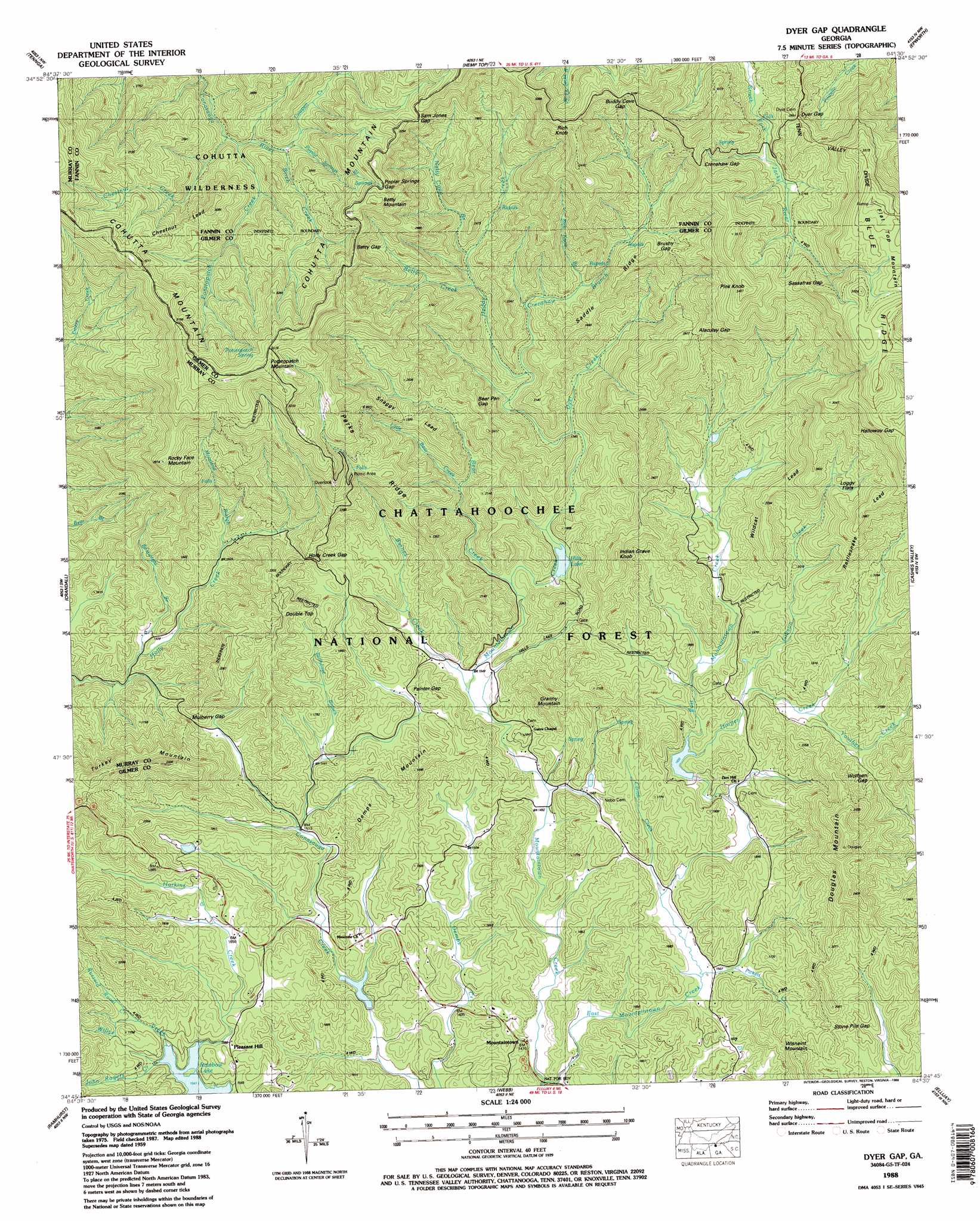
USGS Topo Quad 34084g5 - 1:24,000 scale
| Topo Map Name: | Dyer Gap |
| USGS Topo Quad ID: | 34084g5 |
| Print Size: | ca. 21 1/4" wide x 27" high |
| Southeast Coordinates: | 34.75° N latitude / 84.5° W longitude |
| Map Center Coordinates: | 34.8125° N latitude / 84.5625° W longitude |
| U.S. State: | GA |
| Filename: | o34084g5.jpg |
| Download Map JPG Image: | Dyer Gap topo map 1:24,000 scale |
| Map Type: | Topographic |
| Topo Series: | 7.5´ |
| Map Scale: | 1:24,000 |
| Source of Map Images: | United States Geological Survey (USGS) |
| Alternate Map Versions: |
Dyer Gap GA 1959 Download PDF Buy paper map Dyer Gap GA 1959, updated 1961 Download PDF Buy paper map Dyer Gap GA 1959, updated 1975 Download PDF Buy paper map Dyer Gap GA 1988, updated 1988 Download PDF Buy paper map Dyer Gap GA 2011 Download PDF Buy paper map Dyer Gap GA 2014 Download PDF Buy paper map |
| FStopo: | US Forest Service topo Dyer Gap is available: Download FStopo PDF Download FStopo TIF |
1:24,000 Topo Quads surrounding Dyer Gap
Felker |
Parksville |
Caney Creek |
Ducktown |
Isabella |
Beaverdale |
Tennga |
Hemp Top |
Epworth |
Mineral Bluff |
Chatsworth |
Crandall |
Dyer Gap |
Cashes Valley |
Blue Ridge |
Calhoun Ne |
Ramhurst |
Webb |
Ellijay |
Tickanetley |
Redbud |
Oakman |
Talking Rock |
Dyke |
Amicalola |
> Back to 34084e1 at 1:100,000 scale
> Back to 34084a1 at 1:250,000 scale
> Back to U.S. Topo Maps home
Dyer Gap topo map: Gazetteer
Dyer Gap: Dams
Gibson Lake Dam elevation 502m 1646′Mountaintown Creek Watershed Dam Number One elevation 511m 1676′
Mountaintown Creek Watershed Dam Number Three elevation 435m 1427′
Mountaintown Creek Watershed Dam Number Two elevation 505m 1656′
Rainbow Lake Dam elevation 472m 1548′
Dyer Gap: Flats
Loggy Flats elevation 709m 2326′Dyer Gap: Gaps
Alaculsy Gap elevation 796m 2611′Bear Pen Gap elevation 685m 2247′
Betty Gap elevation 946m 3103′
Brushy Gap elevation 851m 2791′
Buddy Cove Gap elevation 967m 3172′
Crenshaw Gap elevation 954m 3129′
Dyer Gap elevation 874m 2867′
Halloway Gap elevation 987m 3238′
Holly Creek Gap elevation 602m 1975′
Mulberry Gap elevation 532m 1745′
Painter Gap elevation 508m 1666′
Poplar Springs Gap elevation 992m 3254′
Sam Jones Gap elevation 981m 3218′
Sassafras Gap elevation 957m 3139′
Stone Pile Gap elevation 550m 1804′
Wolfpen Gap elevation 585m 1919′
Dyer Gap: Lakes
Hills Lake elevation 505m 1656′Dyer Gap: Populated Places
Conasauga (historical) elevation 464m 1522′Mountaintown elevation 456m 1496′
Pleasant Hill elevation 494m 1620′
Dyer Gap: Reservoirs
Davenport Lake elevation 511m 1676′Gibson Lake elevation 502m 1646′
Hill Lake elevation 501m 1643′
Mountaintown Watershed Lake Number Three elevation 435m 1427′
Dyer Gap: Ridges
Chestnut Lead elevation 932m 3057′Parks Ridge elevation 789m 2588′
Rattlesnake Lead elevation 815m 2673′
Saddle Ridge elevation 761m 2496′
Snaggy Lead elevation 515m 1689′
Wildcat Lead elevation 696m 2283′
Dyer Gap: Springs
Potatopatch Spring elevation 1008m 3307′Dyer Gap: Streams
Barnes Creek elevation 468m 1535′Bear Creek elevation 492m 1614′
Betty Creek elevation 612m 2007′
Birch Creek elevation 778m 2552′
Boatwright Branch elevation 447m 1466′
Buzzard Roost Creek elevation 483m 1584′
Carroll Creek elevation 459m 1505′
Chestnut Creek elevation 702m 2303′
Cowpen Creek elevation 778m 2552′
Crenshaw Branch elevation 561m 1840′
Dyer Creek elevation 532m 1745′
East Mountaintown Creek elevation 427m 1400′
Gibson Creek elevation 517m 1696′
Harkins Creek elevation 472m 1548′
Harper Creek elevation 498m 1633′
Heddy Creek elevation 506m 1660′
John Rogers Creek elevation 472m 1548′
Little Bear Creek elevation 555m 1820′
Moreland Branch elevation 506m 1660′
Pickett Creek elevation 462m 1515′
Poplar Springs Branch elevation 730m 2395′
Potatopatch Creek elevation 729m 2391′
Rich Knob Branch elevation 642m 2106′
Stillhouse Branch elevation 464m 1522′
Willys Creek elevation 472m 1548′
Youther Creek elevation 544m 1784′
Dyer Gap: Summits
Bee Knob elevation 472m 1548′Betty Mountain elevation 1023m 3356′
Demps Mountain elevation 601m 1971′
Double Top elevation 673m 2208′
Douglas Mountain elevation 714m 2342′
Granny Mountain elevation 630m 2066′
Indian Grave Knob elevation 723m 2372′
Pink Knob elevation 1060m 3477′
Potatopatch Mountain elevation 1085m 3559′
Rich Knob elevation 1027m 3369′
Rocky Face elevation 903m 2962′
Turkey Mountain elevation 735m 2411′
Wisnaint Mountain elevation 631m 2070′
Dyer Gap: Trails
Bear Creek Trail elevation 579m 1899′Emery Creek Trail elevation 646m 2119′
Mountaintown Creek Trail elevation 588m 1929′
Dyer Gap digital topo map on disk
Buy this Dyer Gap topo map showing relief, roads, GPS coordinates and other geographical features, as a high-resolution digital map file on DVD: