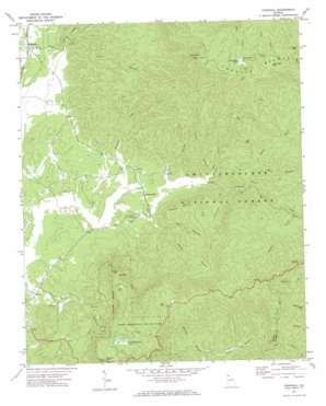
Crandall Topo Map Georgia
To zoom in, hover over the map of Crandall
USGS Topo Quad 34084g6 - 1:24,000 scale
| Topo Map Name: | Crandall |
| USGS Topo Quad ID: | 34084g6 |
| Print Size: | ca. 21 1/4" wide x 27" high |
| Southeast Coordinates: | 34.75° N latitude / 84.625° W longitude |
| Map Center Coordinates: | 34.8125° N latitude / 84.6875° W longitude |
| U.S. State: | GA |
| Filename: | o34084g6.jpg |
| Download Map JPG Image: | Crandall topo map 1:24,000 scale |
| Map Type: | Topographic |
| Topo Series: | 7.5´ |
| Map Scale: | 1:24,000 |
| Source of Map Images: | United States Geological Survey (USGS) |
| Alternate Map Versions: |
Crandall GA 1971, updated 1974 Download PDF Buy paper map Crandall GA 1971, updated 1984 Download PDF Buy paper map Crandall GA 1971, updated 1984 Download PDF Buy paper map Crandall GA 2011 Download PDF Buy paper map Crandall GA 2014 Download PDF Buy paper map |
| FStopo: | US Forest Service topo Crandall is available: Download FStopo PDF Download FStopo TIF |
1:24,000 Topo Quads surrounding Crandall
> Back to 34084e1 at 1:100,000 scale
> Back to 34084a1 at 1:250,000 scale
> Back to U.S. Topo Maps home
Crandall topo map: Gazetteer
Crandall: Bridges
Charlie Kendrick Memorial Bridge elevation 227m 744′Crandall: Dams
Conasauga Lake Dam elevation 957m 3139′McDaniel Lake Dam elevation 779m 2555′
Crandall: Lakes
Conasauga Lake elevation 957m 3139′Fort Mountain Lake elevation 721m 2365′
Crandall: Mines
Cohutta Mine elevation 535m 1755′Fort Mountain Mine elevation 566m 1856′
Southern Mine elevation 354m 1161′
Crandall: Parks
Fort Mountain State Park elevation 792m 2598′Crandall: Populated Places
Crandall elevation 253m 830′Hasslers Mill elevation 256m 839′
Crandall: Reservoirs
McDaniel Lake elevation 779m 2555′Crandall: Springs
Cool Spring elevation 266m 872′Crandall: Streams
Bear Branch elevation 349m 1145′Cohorn Branch elevation 250m 820′
Dill Creek elevation 265m 869′
Emery Branch elevation 305m 1000′
Emery Creek elevation 312m 1023′
Goldmine Branch elevation 328m 1076′
Leadmine Branch elevation 268m 879′
Mill Creek elevation 250m 820′
Milma Branch elevation 267m 875′
Muskrat Creek elevation 243m 797′
Neal Branch elevation 257m 843′
Parr Branch elevation 290m 951′
Rigley Branch elevation 251m 823′
Shanty Creek elevation 394m 1292′
Crandall: Summits
Bald Mountain elevation 1222m 4009′Beaver Mountain elevation 492m 1614′
Cohutta Mountain elevation 1222m 4009′
Fort Mountain elevation 868m 2847′
Grassy Mountain elevation 1125m 3690′
Little Bald Mountain elevation 1126m 3694′
Tatum Mountain elevation 844m 2769′
Crandall: Trails
Grassy Mountain Tower Trail elevation 963m 3159′Songbird Trail elevation 948m 3110′
Crandall digital topo map on disk
Buy this Crandall topo map showing relief, roads, GPS coordinates and other geographical features, as a high-resolution digital map file on DVD:


