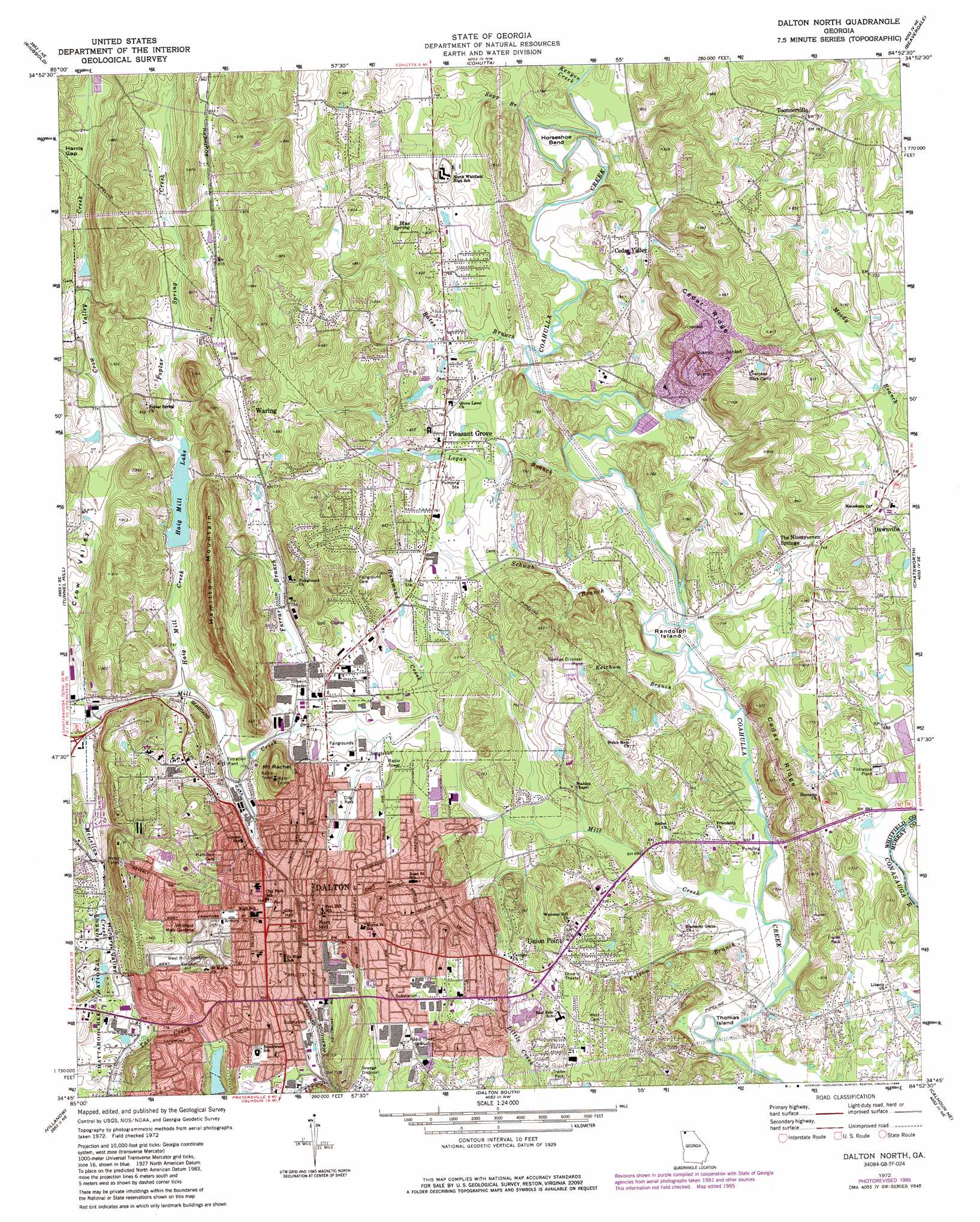
Dalton North Topo Map Georgia
To zoom in, hover over the map of Dalton North
USGS Topo Quad 34084g8 - 1:24,000 scale
| Topo Map Name: | Dalton North |
| USGS Topo Quad ID: | 34084g8 |
| Print Size: | ca. 21 1/4" wide x 27" high |
| Southeast Coordinates: | 34.75° N latitude / 84.875° W longitude |
| Map Center Coordinates: | 34.8125° N latitude / 84.9375° W longitude |
| U.S. State: | GA |
| Filename: | o34084g8.jpg |
| Download Map JPG Image: | Dalton North topo map 1:24,000 scale |
| Map Type: | Topographic |
| Topo Series: | 7.5´ |
| Map Scale: | 1:24,000 |
| Source of Map Images: | United States Geological Survey (USGS) |
| Alternate Map Versions: |
Dalton North GA 1972, updated 1974 Download PDF Buy paper map Dalton North GA 1972, updated 1984 Download PDF Buy paper map Dalton North GA 1972, updated 1988 Download PDF Buy paper map Dalton North GA 2011 Download PDF Buy paper map Dalton North GA 2014 Download PDF Buy paper map |
| FStopo: | US Forest Service topo Dalton North is available: Download FStopo PDF Download FStopo TIF |
1:24,000 Topo Quads surrounding Dalton North
East Chattanooga |
Ooltewah |
Mcdonald |
Felker |
Parksville |
East Ridge |
Ringgold |
Cohutta |
Beaverdale |
Tennga |
Nickajack Gap |
Tunnel Hill |
Dalton North |
Chatsworth |
Crandall |
Catlett |
Villanow |
Dalton South |
Calhoun Ne |
Ramhurst |
Subligna |
Sugar Valley |
Calhoun North |
Redbud |
Oakman |
> Back to 34084e1 at 1:100,000 scale
> Back to 34084a1 at 1:250,000 scale
> Back to U.S. Topo Maps home
Dalton North topo map: Gazetteer
Dalton North: Airports
Hamilton Medical Center Heliport elevation 225m 738′Dalton North: Bends
Horseshoe Bend elevation 215m 705′Dalton North: Dams
Dalton Rock Products Lake Dam elevation 214m 702′Haig Mill Dam elevation 229m 751′
Lakeshores Lake Dam elevation 226m 741′
Mill Creek Watershed Dam Number Nine elevation 227m 744′
Mill Creek Watershed Dam Number Two elevation 253m 830′
Threadmill Lake Dam elevation 216m 708′
Dalton North: Islands
Randolph Island elevation 208m 682′Thomas Island elevation 201m 659′
Dalton North: Mines
Dalton Quarry elevation 244m 800′Dalton North: Parks
Dalton Civic Park elevation 215m 705′Dalton Commercial Historic District elevation 233m 764′
Harmon Field elevation 246m 807′
Lake Shore Park elevation 219m 718′
Dalton North: Populated Places
Cannon Heights elevation 249m 816′Cedar Ridge elevation 222m 728′
Cedar Valley elevation 248m 813′
Dalton elevation 232m 761′
Dawnville elevation 227m 744′
Fillmore (historical) elevation 224m 734′
Pleasant Grove elevation 225m 738′
Toonnerville elevation 230m 754′
Union Point elevation 235m 770′
Waring elevation 263m 862′
Dalton North: Post Offices
Dalton Post Office elevation 234m 767′Dalton North: Reservoirs
Dalton Rock Products Lake elevation 214m 702′Haig Mill Lake elevation 229m 751′
Hawkins Lake elevation 253m 830′
Hiag Mill elevation 224m 734′
Lakeshores Lake elevation 226m 741′
Threadmill Lake elevation 216m 708′
Dalton North: Ridges
Cedar Ridge elevation 263m 862′Cedar Ridge elevation 226m 741′
Dalton North: Springs
Blue Spring elevation 241m 790′Dalton North: Streams
Bates Branch elevation 211m 692′Crow Valley Creek elevation 227m 744′
Farrar Branch elevation 211m 692′
Folsom Branch elevation 204m 669′
Haig Mill Creek elevation 223m 731′
Hammond Creek elevation 217m 711′
Kenyon Creek elevation 217m 711′
Ketchum Branch elevation 206m 675′
Logan Branch elevation 207m 679′
McLellan Creek elevation 216m 708′
Mill Creek elevation 205m 672′
Poplar Spring Creek elevation 232m 761′
Sapp Branch elevation 224m 734′
Schwab Branch elevation 208m 682′
Dalton North: Summits
Fort Hill elevation 240m 787′Hamilton Mountain elevation 272m 892′
Mount Rachel elevation 270m 885′
Dalton North: Valleys
Crow Valley elevation 219m 718′Hungry Valley elevation 243m 797′
Dalton North digital topo map on disk
Buy this Dalton North topo map showing relief, roads, GPS coordinates and other geographical features, as a high-resolution digital map file on DVD: