Culberson Topo Map Georgia
To zoom in, hover over the map of Culberson
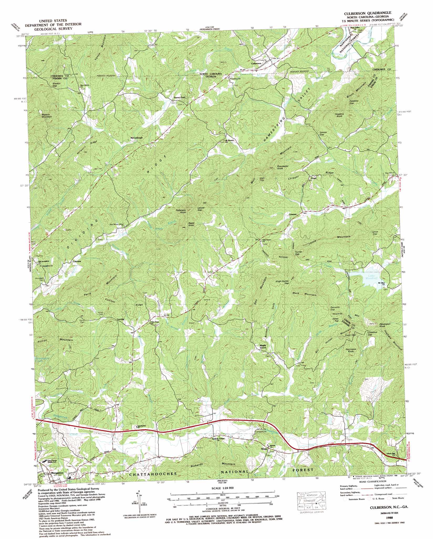
USGS Topo Quad 34084h2 - 1:24,000 scale
| Topo Map Name: | Culberson |
| USGS Topo Quad ID: | 34084h2 |
| Print Size: | ca. 21 1/4" wide x 27" high |
| Southeast Coordinates: | 34.875° N latitude / 84.125° W longitude |
| Map Center Coordinates: | 34.9375° N latitude / 84.1875° W longitude |
| U.S. States: | GA, NC |
| Filename: | o34084h2.jpg |
| Download Map JPG Image: | Culberson topo map 1:24,000 scale |
| Map Type: | Topographic |
| Topo Series: | 7.5´ |
| Map Scale: | 1:24,000 |
| Source of Map Images: | United States Geological Survey (USGS) |
| Alternate Map Versions: |
Culberson NC 1935 Download PDF Buy paper map Culberson NC 1941, updated 1958 Download PDF Buy paper map Culberson NC 1941, updated 1969 Download PDF Buy paper map Culberson NC 1941, updated 1973 Download PDF Buy paper map Culberson NC 1941, updated 1975 Download PDF Buy paper map Culberson NC 1942 Download PDF Buy paper map Culberson NC 1988, updated 1988 Download PDF Buy paper map Culberson NC 2011 Download PDF Buy paper map Culberson NC 2013 Download PDF Buy paper map Culberson NC 2016 Download PDF Buy paper map |
| FStopo: | US Forest Service topo Culberson is available: Download FStopo PDF Download FStopo TIF |
1:24,000 Topo Quads surrounding Culberson
Mcfarland |
Farner |
Unaka |
Mcdaniel Bald |
Marble |
Ducktown |
Isabella |
Persimmon Creek |
Murphy |
Peachtree |
Epworth |
Mineral Bluff |
Culberson |
Nottely Dam |
Blairsville |
Cashes Valley |
Blue Ridge |
Wilscot |
Mulky Gap |
Coosa Bald |
Ellijay |
Tickanetley |
Noontootla |
Suches |
Neels Gap |
> Back to 34084e1 at 1:100,000 scale
> Back to 34084a1 at 1:250,000 scale
> Back to U.S. Topo Maps home
Culberson topo map: Gazetteer
Culberson: Gaps
Chestnut Gap elevation 688m 2257′Coon Gap elevation 711m 2332′
Darneille Gap elevation 671m 2201′
Hawkins Gap elevation 649m 2129′
Jonica Gap elevation 607m 1991′
Lance Gap elevation 640m 2099′
Locust Gap elevation 701m 2299′
Turner Gap elevation 672m 2204′
Virgil Hunter Gap elevation 697m 2286′
Watson Gap elevation 609m 1998′
Culberson: Lakes
Lake Woodruff elevation 578m 1896′Culberson: Populated Places
Brown Mill elevation 513m 1683′Bryan Mill elevation 554m 1817′
Culberson elevation 496m 1627′
Cutcane elevation 513m 1683′
Dora (historical) elevation 609m 1998′
Forge Mill elevation 498m 1633′
Hemp elevation 572m 1876′
Lance Mill elevation 540m 1771′
Lewner elevation 571m 1873′
Loving elevation 608m 1994′
Maple Grove elevation 605m 1984′
Mashburn Mill elevation 577m 1893′
McCullough elevation 523m 1715′
Pearl elevation 624m 2047′
Rocky Gap (historical) elevation 557m 1827′
Sparks Mill elevation 582m 1909′
Sweet Gum elevation 516m 1692′
Thomas Mill elevation 578m 1896′
Watson Gap (historical) elevation 575m 1886′
Wright Mill elevation 556m 1824′
Culberson: Ridges
Bruce Mountain elevation 645m 2116′Chigger Ridge elevation 621m 2037′
Cutcane Ridge elevation 644m 2112′
Dividing Ridge elevation 583m 1912′
Hogback Mountain elevation 766m 2513′
Mack Mountain elevation 696m 2283′
Millpond Ridge elevation 622m 2040′
Mull Mountain elevation 706m 2316′
Richards Mountain elevation 633m 2076′
Culberson: Streams
Beck Branch elevation 561m 1840′Bryan Creek elevation 524m 1719′
Cook Creek elevation 546m 1791′
Falling Down Branch elevation 505m 1656′
Galloway Branch elevation 525m 1722′
Hunter Branch elevation 561m 1840′
Jones Branch elevation 608m 1994′
Mill Branch elevation 549m 1801′
Mitchell Branch elevation 548m 1797′
Mull Creek elevation 533m 1748′
Owenby Creek elevation 479m 1571′
Owenby Creek elevation 479m 1571′
Owenby Creek elevation 480m 1574′
Pounding Mill Branch elevation 488m 1601′
Richards Branch elevation 533m 1748′
Tarpley Branch elevation 497m 1630′
Williams Branch elevation 512m 1679′
Wright Mill Branch elevation 520m 1706′
Culberson: Summits
Bill Hunter Mountain elevation 733m 2404′Dan Mountain elevation 733m 2404′
Davenport Knob elevation 736m 2414′
Hawkins Knob elevation 710m 2329′
High Top elevation 713m 2339′
Hurricane Knob elevation 722m 2368′
Jones Top elevation 699m 2293′
Lance Mountain elevation 698m 2290′
Paris Mountain elevation 697m 2286′
Patterson Knob elevation 748m 2454′
Poindexter Knob elevation 746m 2447′
Raper Knob elevation 746m 2447′
Thomas Mountain elevation 615m 2017′
Watson Mountain elevation 817m 2680′
Culberson: Valleys
Hamestring Valley elevation 479m 1571′Hamstring Valley elevation 481m 1578′
Norman Cove elevation 571m 1873′
Culberson digital topo map on disk
Buy this Culberson topo map showing relief, roads, GPS coordinates and other geographical features, as a high-resolution digital map file on DVD: