Ballplay Topo Map Alabama
To zoom in, hover over the map of Ballplay
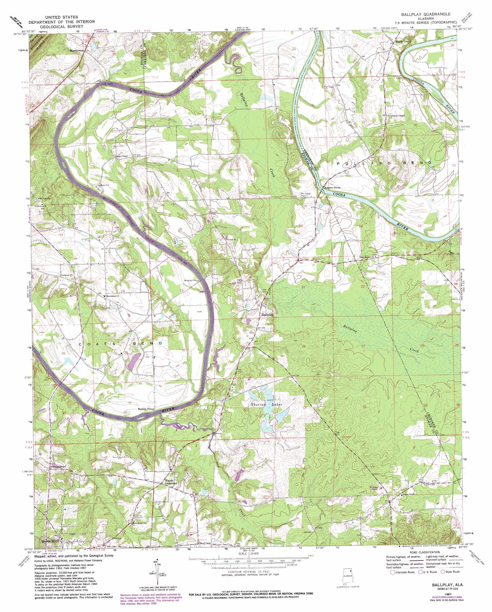
USGS Topo Quad 34085a7 - 1:24,000 scale
| Topo Map Name: | Ballplay |
| USGS Topo Quad ID: | 34085a7 |
| Print Size: | ca. 21 1/4" wide x 27" high |
| Southeast Coordinates: | 34° N latitude / 85.75° W longitude |
| Map Center Coordinates: | 34.0625° N latitude / 85.8125° W longitude |
| U.S. State: | AL |
| Filename: | o34085a7.jpg |
| Download Map JPG Image: | Ballplay topo map 1:24,000 scale |
| Map Type: | Topographic |
| Topo Series: | 7.5´ |
| Map Scale: | 1:24,000 |
| Source of Map Images: | United States Geological Survey (USGS) |
| Alternate Map Versions: |
Ballplay AL 1967, updated 1970 Download PDF Buy paper map Ballplay AL 1967, updated 1984 Download PDF Buy paper map Ballplay AL 1967, updated 1987 Download PDF Buy paper map Ballplay AL 2011 Download PDF Buy paper map Ballplay AL 2014 Download PDF Buy paper map |
1:24,000 Topo Quads surrounding Ballplay
Painter |
Crossville |
Portersville |
Little River |
Gaylesville |
Rodentown |
Keener |
Leesburg |
Centre |
Cedar Bluff |
Gadsden West |
Gadsden East |
Ballplay |
Weisner Mountain |
Ellisville |
Dunaway Mountain |
Glencoe |
Colvin Gap |
Piedmont Nw |
Piedmont |
Ohatchee |
Wellington |
Jacksonville West |
Jacksonville East |
Piedmont Se |
> Back to 34085a1 at 1:100,000 scale
> Back to 34084a1 at 1:250,000 scale
> Back to U.S. Topo Maps home
Ballplay topo map: Gazetteer
Ballplay: Bends
Ballplay Bend elevation 163m 534′Coats Bend elevation 169m 554′
Pollard Bend elevation 174m 570′
Ballplay: Crossings
Adams Ferry elevation 155m 508′Baskin Ferry (historical) elevation 155m 508′
Croft Ferry (historical) elevation 155m 508′
Wagnon Ferry (historical) elevation 155m 508′
Wood Ferry (historical) elevation 165m 541′
Ballplay: Dams
Thorton Number 1 Dam elevation 162m 531′Thorton Number 2 Dam elevation 168m 551′
Thorton Number 3 Dam elevation 166m 544′
Thorton Number 4 Dam elevation 169m 554′
Thorton Number 5 Dam elevation 171m 561′
Thorton Number 6 Dam elevation 169m 554′
Thorval Dam elevation 162m 531′
Ballplay: Populated Places
Bachelors Chapel elevation 186m 610′Ballplay elevation 181m 593′
Banner (historical) elevation 186m 610′
Coato Bend (historical) elevation 172m 564′
Hale (historical) elevation 176m 577′
Maple Grove elevation 185m 606′
Mayes Crossroad elevation 187m 613′
Murrycross elevation 165m 541′
Oak Hill (historical) elevation 169m 554′
Ballplay: Post Offices
Banner Post Office (historical) elevation 186m 610′Ballplay: Reservoirs
Thornton Number 1 Lake elevation 162m 531′Thornton Number 2 Lake elevation 168m 551′
Thornton Number 3 Lake elevation 166m 544′
Thornton Number 4 Lake elevation 169m 554′
Thornton Number 5 Lake elevation 171m 561′
Thornton Number 6 Lake elevation 169m 554′
Thorton Lakes elevation 163m 534′
Thorval Lake elevation 162m 531′
Ballplay: Streams
Ballplay Creek elevation 155m 508′Dry Creek elevation 155m 508′
Hollow Rock Branch elevation 155m 508′
Sugar Creek elevation 157m 515′
Ballplay digital topo map on disk
Buy this Ballplay topo map showing relief, roads, GPS coordinates and other geographical features, as a high-resolution digital map file on DVD: