Gadsden East Topo Map Alabama
To zoom in, hover over the map of Gadsden East
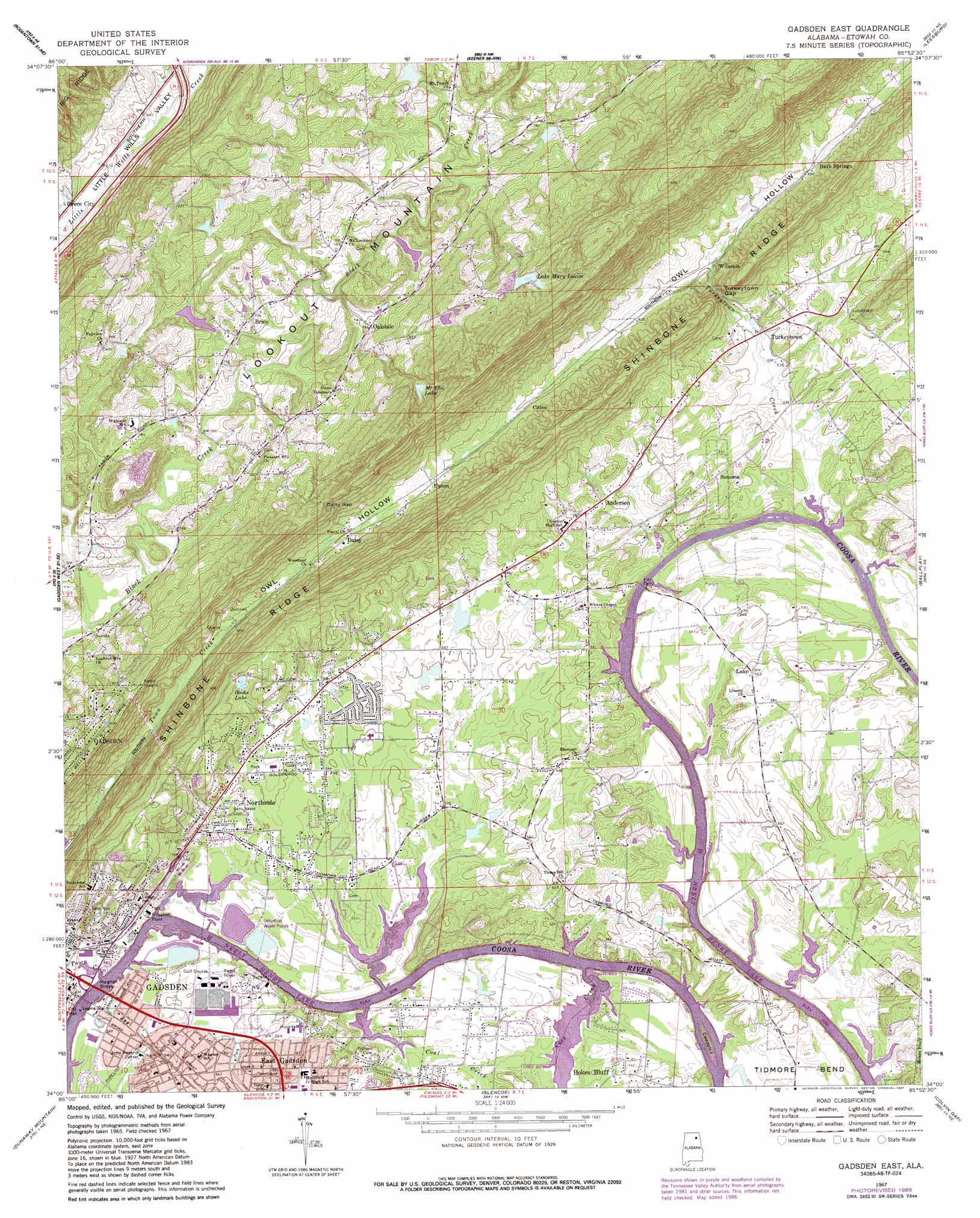
USGS Topo Quad 34085a8 - 1:24,000 scale
| Topo Map Name: | Gadsden East |
| USGS Topo Quad ID: | 34085a8 |
| Print Size: | ca. 21 1/4" wide x 27" high |
| Southeast Coordinates: | 34° N latitude / 85.875° W longitude |
| Map Center Coordinates: | 34.0625° N latitude / 85.9375° W longitude |
| U.S. State: | AL |
| Filename: | o34085a8.jpg |
| Download Map JPG Image: | Gadsden East topo map 1:24,000 scale |
| Map Type: | Topographic |
| Topo Series: | 7.5´ |
| Map Scale: | 1:24,000 |
| Source of Map Images: | United States Geological Survey (USGS) |
| Alternate Map Versions: |
Gadsden East AL 1967, updated 1970 Download PDF Buy paper map Gadsden East AL 1967, updated 1987 Download PDF Buy paper map Gadsden East AL 2011 Download PDF Buy paper map Gadsden East AL 2014 Download PDF Buy paper map |
1:24,000 Topo Quads surrounding Gadsden East
Albertville |
Painter |
Crossville |
Portersville |
Little River |
Boaz |
Rodentown |
Keener |
Leesburg |
Centre |
Howelton |
Gadsden West |
Gadsden East |
Ballplay |
Weisner Mountain |
Steele |
Dunaway Mountain |
Glencoe |
Colvin Gap |
Piedmont Nw |
Cox Gap |
Ohatchee |
Wellington |
Jacksonville West |
Jacksonville East |
> Back to 34085a1 at 1:100,000 scale
> Back to 34084a1 at 1:250,000 scale
> Back to U.S. Topo Maps home
Gadsden East topo map: Gazetteer
Gadsden East: Bends
Alfords Bend elevation 166m 544′Tillisons Bend elevation 159m 521′
Gadsden East: Bridges
Meighan Bridge elevation 155m 508′Memorial Bridge elevation 155m 508′
Gadsden East: Crossings
Caddels Ford elevation 155m 508′Fitts Ferry elevation 155m 508′
Kay Ferry (historical) elevation 155m 508′
Wisdom Ferry (historical) elevation 155m 508′
Gadsden East: Dams
Ash Disposal Pond Dam elevation 157m 515′Camp Sequoyah Dam elevation 238m 780′
Estess Dam elevation 170m 557′
Goodyear Dam elevation 163m 534′
Hardin Dam elevation 320m 1049′
Gadsden East: Gaps
Daisy Gap elevation 306m 1003′Turkeytown Gap elevation 169m 554′
Gadsden East: Islands
Caddell Island elevation 155m 508′Gadsden East: Parks
North Gadsden Park elevation 171m 561′Gadsden East: Populated Places
Anderson elevation 172m 564′Bath Springs elevation 201m 659′
Brice elevation 237m 777′
Citico elevation 207m 679′
Daisy elevation 218m 715′
East Gadsden elevation 174m 570′
Edwardsville elevation 180m 590′
Fairview elevation 261m 856′
Goodyear elevation 159m 521′
Hooks Lake Subdivision elevation 193m 633′
Luke elevation 171m 561′
Noojinsville elevation 164m 538′
Northside elevation 171m 561′
Oakdale elevation 232m 761′
Sonoma elevation 180m 590′
Turkeytown elevation 167m 547′
Upton elevation 219m 718′
Whites Chapel elevation 173m 567′
Wilsonia elevation 176m 577′
Wilsons (historical) elevation 239m 784′
Gadsden East: Reservoirs
Ash Disposal Pond elevation 157m 515′Camp Sequoyah Lake elevation 238m 780′
Estess Lake elevation 170m 557′
Goodyear Lake elevation 163m 534′
Hooks Lake elevation 190m 623′
Lake Mary Louise elevation 326m 1069′
Mount Eba Lake elevation 292m 958′
Gadsden East: Springs
Boy Scouts Spring elevation 181m 593′Chappell Spring elevation 181m 593′
Hooks Lake Spring elevation 171m 561′
Gadsden East: Streams
Coal Creek elevation 155m 508′Cove Creek elevation 155m 508′
Town Creek elevation 158m 518′
Turkeytown Creek elevation 155m 508′
Gadsden East: Summits
Ewing Hill elevation 208m 682′Gadsden East digital topo map on disk
Buy this Gadsden East topo map showing relief, roads, GPS coordinates and other geographical features, as a high-resolution digital map file on DVD: