Centre Topo Map Alabama
To zoom in, hover over the map of Centre
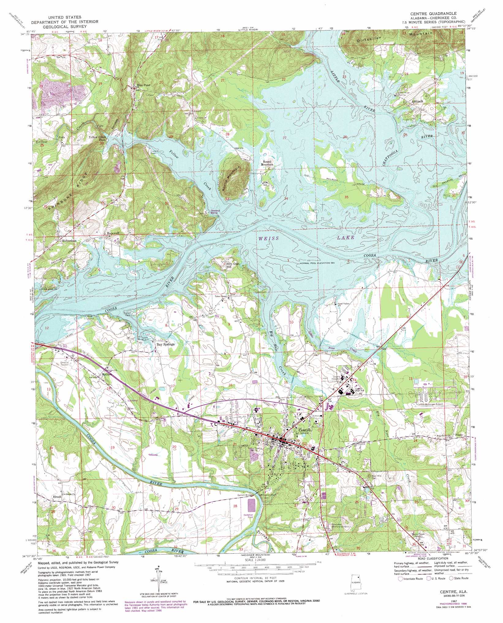
USGS Topo Quad 34085b6 - 1:24,000 scale
| Topo Map Name: | Centre |
| USGS Topo Quad ID: | 34085b6 |
| Print Size: | ca. 21 1/4" wide x 27" high |
| Southeast Coordinates: | 34.125° N latitude / 85.625° W longitude |
| Map Center Coordinates: | 34.1875° N latitude / 85.6875° W longitude |
| U.S. State: | AL |
| Filename: | o34085b6.jpg |
| Download Map JPG Image: | Centre topo map 1:24,000 scale |
| Map Type: | Topographic |
| Topo Series: | 7.5´ |
| Map Scale: | 1:24,000 |
| Source of Map Images: | United States Geological Survey (USGS) |
| Alternate Map Versions: |
Centre AL 1967, updated 1969 Download PDF Buy paper map Centre AL 1967, updated 1977 Download PDF Buy paper map Centre AL 1967, updated 1987 Download PDF Buy paper map Centre AL 2011 Download PDF Buy paper map Centre AL 2014 Download PDF Buy paper map |
1:24,000 Topo Quads surrounding Centre
Fyffe |
Chavies |
Fort Payne |
Jamestown |
Lyerly |
Crossville |
Portersville |
Little River |
Gaylesville |
Chattoogaville |
Keener |
Leesburg |
Centre |
Cedar Bluff |
Melson |
Gadsden East |
Ballplay |
Weisner Mountain |
Ellisville |
Indian Mountain |
Glencoe |
Colvin Gap |
Piedmont Nw |
Piedmont |
Borden Springs |
> Back to 34085a1 at 1:100,000 scale
> Back to 34084a1 at 1:250,000 scale
> Back to U.S. Topo Maps home
Centre topo map: Gazetteer
Centre: Airports
Centre Municipal Airport elevation 184m 603′Centre: Bays
Anderson Cove elevation 172m 564′Black Mallard Cove elevation 172m 564′
Chestnut Cove elevation 172m 564′
Hawthorn Cove elevation 172m 564′
Centre: Bridges
Garrett Bridge elevation 158m 518′Centre: Crossings
Bradford Ferry (historical) elevation 177m 580′Edwards Ferry (historical) elevation 172m 564′
Ewing Ferry (historical) elevation 173m 567′
Garrett Ferry (historical) elevation 158m 518′
Westmoreland Ferry (historical) elevation 172m 564′
Centre: Islands
Buffingtons Island elevation 173m 567′Hog Island elevation 177m 580′
Centre: Parks
Centre City Park elevation 184m 603′Ethel Morrison Memorial Park elevation 200m 656′
Windom Ball Field elevation 181m 593′
Centre: Populated Places
Anderson elevation 179m 587′Antioch elevation 182m 597′
Antioch Estates elevation 192m 629′
Bay Springs elevation 174m 570′
Bay View Estates elevation 180m 590′
Big Nose Creek Subdivision elevation 181m 593′
Billy Goat Hill elevation 186m 610′
Blue Pond elevation 200m 656′
Brooks Estates elevation 187m 613′
Burkhalter Subdivision elevation 177m 580′
Centre elevation 202m 662′
Coosa River Subdivision elevation 168m 551′
Elrath elevation 187m 613′
Griffin elevation 185m 606′
Hopewell elevation 179m 587′
McGhee elevation 171m 561′
Northwood Estates elevation 183m 600′
Piney elevation 206m 675′
Richardson elevation 180m 590′
Roberts Subdivision elevation 180m 590′
Round Mountain elevation 176m 577′
Shangrila elevation 174m 570′
Turkey Town (historical) elevation 166m 544′
Weiss Dam elevation 171m 561′
Yellow Creek View Subdivision elevation 192m 629′
Centre: Post Offices
Centre Post Office elevation 202m 662′Centre: Streams
Big Nose Creek elevation 172m 564′Little River elevation 172m 564′
Muddy Branch elevation 172m 564′
Terrapin Creek elevation 158m 518′
Yellow Creek elevation 172m 564′
Centre: Summits
Graveyard Hill elevation 185m 606′Round Mountain elevation 263m 862′
Centre digital topo map on disk
Buy this Centre topo map showing relief, roads, GPS coordinates and other geographical features, as a high-resolution digital map file on DVD: