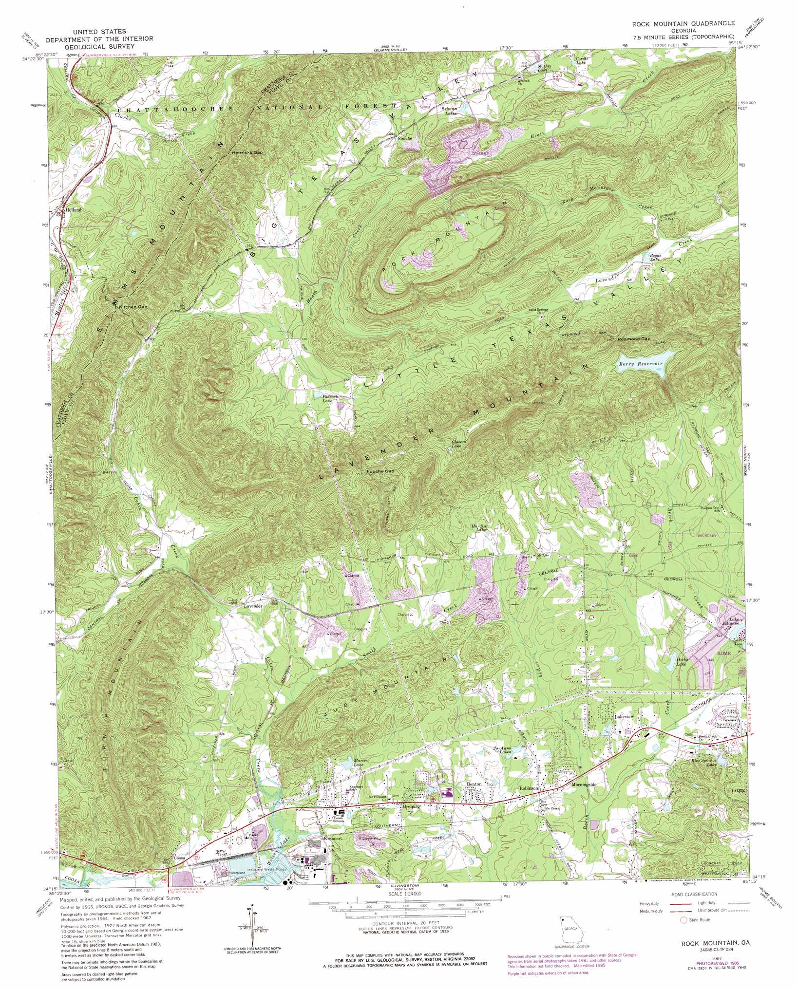
Rock Mountain Topo Map Georgia
To zoom in, hover over the map of Rock Mountain
USGS Topo Quad 34085c3 - 1:24,000 scale
| Topo Map Name: | Rock Mountain |
| USGS Topo Quad ID: | 34085c3 |
| Print Size: | ca. 21 1/4" wide x 27" high |
| Southeast Coordinates: | 34.25° N latitude / 85.25° W longitude |
| Map Center Coordinates: | 34.3125° N latitude / 85.3125° W longitude |
| U.S. State: | GA |
| Filename: | o34085c3.jpg |
| Download Map JPG Image: | Rock Mountain topo map 1:24,000 scale |
| Map Type: | Topographic |
| Topo Series: | 7.5´ |
| Map Scale: | 1:24,000 |
| Source of Map Images: | United States Geological Survey (USGS) |
| Alternate Map Versions: |
Rock Mountain GA 1967, updated 1968 Download PDF Buy paper map Rock Mountain GA 1967, updated 1986 Download PDF Buy paper map Rock Mountain GA 2011 Download PDF Buy paper map Rock Mountain GA 2014 Download PDF Buy paper map |
| FStopo: | US Forest Service topo Rock Mountain is available: Download FStopo PDF Download FStopo TIF |
1:24,000 Topo Quads surrounding Rock Mountain
Valley Head |
Dougherty Gap |
Trion |
Subligna |
Sugar Valley |
Jamestown |
Lyerly |
Summerville |
Armuchee |
Plainville |
Gaylesville |
Chattoogaville |
Rock Mountain |
Rome North |
Shannon |
Cedar Bluff |
Melson |
Livingston |
Rome South |
Wax |
Ellisville |
Indian Mountain |
Cedartown West |
Cedartown East |
Rockmart North |
> Back to 34085a1 at 1:100,000 scale
> Back to 34084a1 at 1:250,000 scale
> Back to U.S. Topo Maps home
Rock Mountain topo map: Gazetteer
Rock Mountain: Dams
Berry Reservoir Dam elevation 266m 872′Rock Mountain: Gaps
Fouche Gap elevation 368m 1207′Henricks Gap elevation 298m 977′
Kitchen Gap elevation 333m 1092′
Redmond Gap elevation 335m 1099′
Rock Mountain: Lakes
Boggs Lake elevation 213m 698′Glovers Lake elevation 431m 1414′
Hardin Lake elevation 207m 679′
Hicks Lake elevation 184m 603′
Jo-Anns Lakes elevation 190m 623′
Lake Julianne elevation 196m 643′
Mathis Lake elevation 216m 708′
Peacock Lake elevation 225m 738′
Selman Lakes elevation 212m 695′
Rock Mountain: Populated Places
Beech Creek Homes elevation 197m 646′Benton elevation 189m 620′
Berryhill elevation 199m 652′
Bone elevation 195m 639′
Coosa elevation 181m 593′
Fouche elevation 211m 692′
Holland elevation 213m 698′
Krannert elevation 179m 587′
Lakeview elevation 199m 652′
Lavender elevation 195m 639′
Morningside elevation 189m 620′
Oreburg elevation 189m 620′
Rice Springs Estates elevation 213m 698′
Robinson elevation 195m 639′
Rollingwood elevation 195m 639′
Williamsburg Estates elevation 199m 652′
Rock Mountain: Post Offices
Coosa Post Office elevation 190m 623′Rock Mountain: Reservoirs
Berry Reservoir elevation 266m 872′Cordle Lake elevation 209m 685′
Martin Lake elevation 192m 629′
Meadow Lake elevation 188m 616′
Rice Springs Lake elevation 204m 669′
Rock Mountain: Ridges
Turnip Mountain elevation 433m 1420′Rock Mountain: Springs
Beard Spring elevation 212m 695′Rices Spring elevation 204m 669′
Sand Spring elevation 213m 698′
Rock Mountain: Streams
Cabin Creek elevation 175m 574′Dry Creek elevation 182m 597′
Funderburk Creek elevation 182m 597′
Rock Mountain Creek elevation 207m 679′
Smith Creek elevation 177m 580′
Rock Mountain: Summits
Judy Mountain elevation 246m 807′Rock Mountain elevation 422m 1384′
Rock Mountain digital topo map on disk
Buy this Rock Mountain topo map showing relief, roads, GPS coordinates and other geographical features, as a high-resolution digital map file on DVD: