Chattoogaville Topo Map Georgia
To zoom in, hover over the map of Chattoogaville
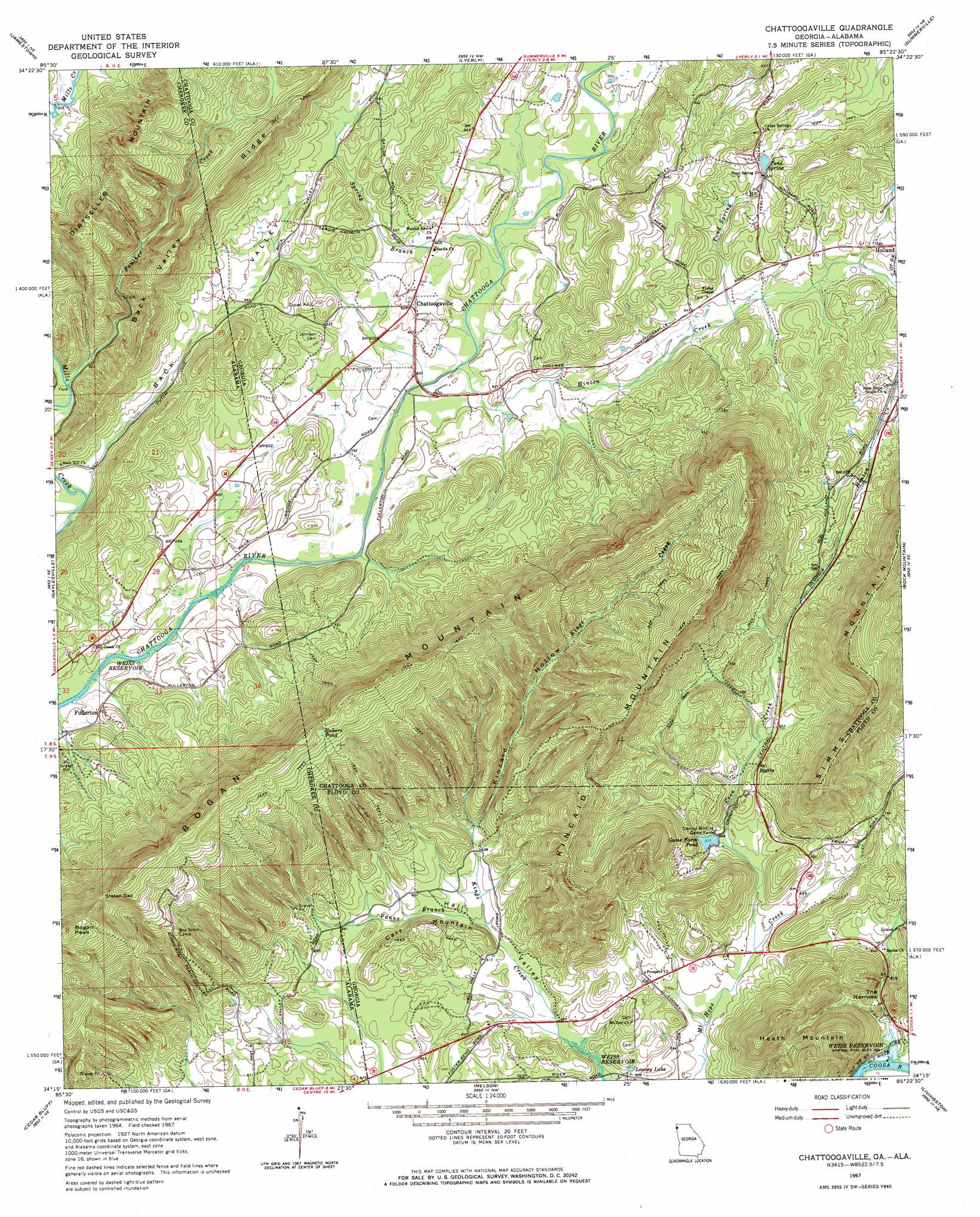
USGS Topo Quad 34085c4 - 1:24,000 scale
| Topo Map Name: | Chattoogaville |
| USGS Topo Quad ID: | 34085c4 |
| Print Size: | ca. 21 1/4" wide x 27" high |
| Southeast Coordinates: | 34.25° N latitude / 85.375° W longitude |
| Map Center Coordinates: | 34.3125° N latitude / 85.4375° W longitude |
| U.S. States: | GA, AL |
| Filename: | o34085c4.jpg |
| Download Map JPG Image: | Chattoogaville topo map 1:24,000 scale |
| Map Type: | Topographic |
| Topo Series: | 7.5´ |
| Map Scale: | 1:24,000 |
| Source of Map Images: | United States Geological Survey (USGS) |
| Alternate Map Versions: |
Chattoogaville GA 1967, updated 1968 Download PDF Buy paper map Chattoogaville GA 2011 Download PDF Buy paper map Chattoogaville GA 2014 Download PDF Buy paper map |
1:24,000 Topo Quads surrounding Chattoogaville
Dugout Valley |
Valley Head |
Dougherty Gap |
Trion |
Subligna |
Fort Payne |
Jamestown |
Lyerly |
Summerville |
Armuchee |
Little River |
Gaylesville |
Chattoogaville |
Rock Mountain |
Rome North |
Centre |
Cedar Bluff |
Melson |
Livingston |
Rome South |
Weisner Mountain |
Ellisville |
Indian Mountain |
Cedartown West |
Cedartown East |
> Back to 34085a1 at 1:100,000 scale
> Back to 34084a1 at 1:250,000 scale
> Back to U.S. Topo Maps home
Chattoogaville topo map: Gazetteer
Chattoogaville: Bridges
Prices Bridge elevation 178m 583′Chattoogaville: Dams
Game Farm Pond Dam elevation 200m 656′Chattoogaville: Gaps
Staton Gap elevation 411m 1348′The Narrows elevation 187m 613′
Chattoogaville: Lakes
Bakers Pond elevation 396m 1299′Chattoogaville: Populated Places
Cedar Springs (historical) elevation 189m 620′Chattoogaville elevation 188m 616′
Fullerton elevation 191m 626′
Hall Valley elevation 207m 679′
Poetry elevation 210m 688′
Sprite elevation 207m 679′
Chattoogaville: Reservoirs
Game Farm Pond elevation 191m 626′Looney Lake elevation 186m 610′
Chattoogaville: Ridges
Back Valley Ridge elevation 337m 1105′Bogan Mountain elevation 407m 1335′
Chattoogaville: Springs
Pond Spring elevation 219m 718′Chattoogaville: Streams
Coon Creek elevation 183m 600′Hinton Creek elevation 178m 583′
Panther Creek elevation 186m 610′
Pond Spring Branch elevation 199m 652′
Spring Branch elevation 180m 590′
Vanns Branch elevation 183m 600′
Vanns Branch elevation 183m 600′
Chattoogaville: Summits
Bogan Mountain elevation 429m 1407′Bogan Peak elevation 505m 1656′
Carr Mountain elevation 234m 767′
Heath Mountain elevation 378m 1240′
Kincaid Mountain elevation 415m 1361′
Chattoogaville: Valleys
Back Valley elevation 183m 600′Hall Valley elevation 177m 580′
Kincaid Hollow elevation 193m 633′
Chattoogaville digital topo map on disk
Buy this Chattoogaville topo map showing relief, roads, GPS coordinates and other geographical features, as a high-resolution digital map file on DVD: