Chavies Topo Map Alabama
To zoom in, hover over the map of Chavies
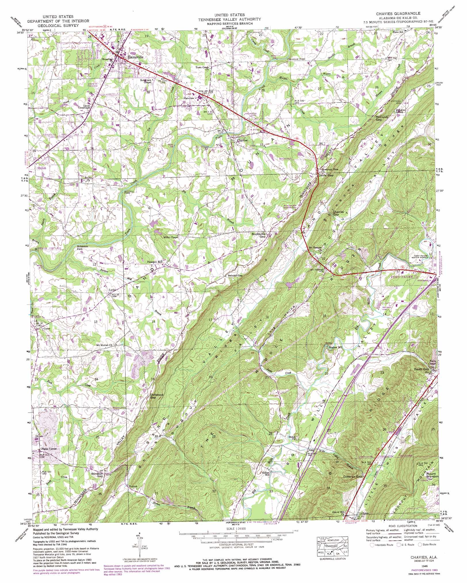
USGS Topo Quad 34085d7 - 1:24,000 scale
| Topo Map Name: | Chavies |
| USGS Topo Quad ID: | 34085d7 |
| Print Size: | ca. 21 1/4" wide x 27" high |
| Southeast Coordinates: | 34.375° N latitude / 85.75° W longitude |
| Map Center Coordinates: | 34.4375° N latitude / 85.8125° W longitude |
| U.S. State: | AL |
| Filename: | o34085d7.jpg |
| Download Map JPG Image: | Chavies topo map 1:24,000 scale |
| Map Type: | Topographic |
| Topo Series: | 7.5´ |
| Map Scale: | 1:24,000 |
| Source of Map Images: | United States Geological Survey (USGS) |
| Alternate Map Versions: |
Chavies AL 1936, updated 1936 Download PDF Buy paper map Chavies AL 1946, updated 1972 Download PDF Buy paper map Chavies AL 1946, updated 1985 Download PDF Buy paper map Chavies AL 1947, updated 1947 Download PDF Buy paper map Chavies AL 2011 Download PDF Buy paper map Chavies AL 2014 Download PDF Buy paper map |
1:24,000 Topo Quads surrounding Chavies
Scottsboro |
Hollywood |
Henagar |
Ider |
Sulphur Springs |
Langston |
Dutton |
Sylvania |
Dugout Valley |
Valley Head |
Grove Oak |
Fyffe |
Chavies |
Fort Payne |
Jamestown |
Painter |
Crossville |
Portersville |
Little River |
Gaylesville |
Rodentown |
Keener |
Leesburg |
Centre |
Cedar Bluff |
> Back to 34085a1 at 1:100,000 scale
> Back to 34084a1 at 1:250,000 scale
> Back to U.S. Topo Maps home
Chavies topo map: Gazetteer
Chavies: Crossings
Bohannon Ford elevation 338m 1108′Franklin Ford elevation 355m 1164′
Suttell Ford elevation 346m 1135′
Chavies: Gaps
Bootsville Gap elevation 384m 1259′Chavies Gap elevation 281m 921′
Chitwood Gap elevation 388m 1272′
Collbran Gap elevation 243m 797′
Davis Gap elevation 396m 1299′
Davis Gap elevation 267m 875′
McCurdy Gap elevation 388m 1272′
Winston Gap elevation 386m 1266′
Chavies: Populated Places
Bootsville (historical) elevation 265m 869′Chavies elevation 361m 1184′
Collbran elevation 273m 895′
Guest elevation 356m 1167′
Horton elevation 281m 921′
Hughes Mill elevation 243m 797′
Killian Mill elevation 230m 754′
Lands Crossroads elevation 383m 1256′
Luna (historical) elevation 379m 1243′
Lydia elevation 373m 1223′
Peeks Corner elevation 392m 1286′
Pine Ridge elevation 291m 954′
Plainview elevation 384m 1259′
Pleasant Hill elevation 379m 1243′
Rainsville elevation 391m 1282′
Chavies: Ridges
Big Ridge elevation 368m 1207′The Middle Ridges elevation 323m 1059′
Chavies: Springs
Hawkins Spring elevation 308m 1010′Chavies: Streams
Big Branch elevation 346m 1135′Brown Branch elevation 334m 1095′
Bynum Mill Branch elevation 338m 1108′
Caney Creek elevation 357m 1171′
Ivy Creek elevation 346m 1135′
Jacks Creek elevation 231m 757′
Little Wills Valley Branch elevation 226m 741′
Morgan Creek elevation 353m 1158′
Shankle Branch elevation 359m 1177′
Sparks Branch elevation 341m 1118′
Wooten Branch elevation 370m 1213′
Chavies: Summits
Mount Brandon elevation 506m 1660′Chavies: Valleys
Long Hollow elevation 248m 813′Chavies digital topo map on disk
Buy this Chavies topo map showing relief, roads, GPS coordinates and other geographical features, as a high-resolution digital map file on DVD: