Sugar Valley Topo Map Georgia
To zoom in, hover over the map of Sugar Valley
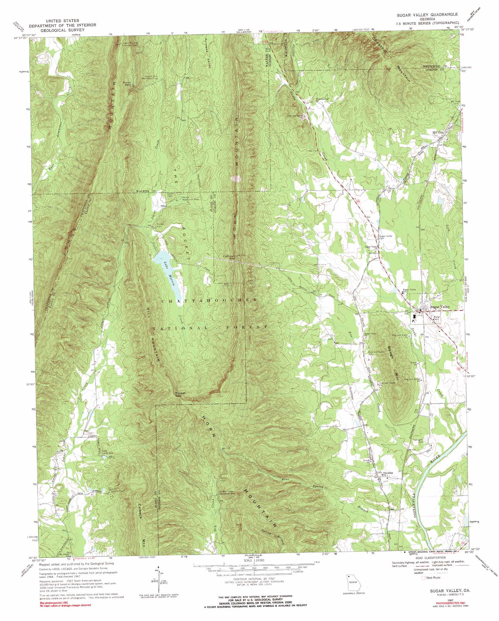
USGS Topo Quad 34085e1 - 1:24,000 scale
| Topo Map Name: | Sugar Valley |
| USGS Topo Quad ID: | 34085e1 |
| Print Size: | ca. 21 1/4" wide x 27" high |
| Southeast Coordinates: | 34.5° N latitude / 85° W longitude |
| Map Center Coordinates: | 34.5625° N latitude / 85.0625° W longitude |
| U.S. State: | GA |
| Filename: | o34085e1.jpg |
| Download Map JPG Image: | Sugar Valley topo map 1:24,000 scale |
| Map Type: | Topographic |
| Topo Series: | 7.5´ |
| Map Scale: | 1:24,000 |
| Source of Map Images: | United States Geological Survey (USGS) |
| Alternate Map Versions: |
Sugar Valley GA 1967, updated 1970 Download PDF Buy paper map Sugar Valley GA 1967, updated 1991 Download PDF Buy paper map Sugar Valley GA 2011 Download PDF Buy paper map Sugar Valley GA 2014 Download PDF Buy paper map |
| FStopo: | US Forest Service topo Sugar Valley is available: Download FStopo PDF Download FStopo TIF |
1:24,000 Topo Quads surrounding Sugar Valley
Kensington |
Nickajack Gap |
Tunnel Hill |
Dalton North |
Chatsworth |
Estelle |
Catlett |
Villanow |
Dalton South |
Calhoun Ne |
Trion |
Subligna |
Sugar Valley |
Calhoun North |
Redbud |
Summerville |
Armuchee |
Plainville |
Calhoun South |
Sonoraville |
Rock Mountain |
Rome North |
Shannon |
Adairsville |
White West |
> Back to 34085e1 at 1:100,000 scale
> Back to 34084a1 at 1:250,000 scale
> Back to U.S. Topo Maps home
Sugar Valley topo map: Gazetteer
Sugar Valley: Basins
The Pocket elevation 287m 941′Sugar Valley: Bends
Hunt Bend elevation 183m 600′Sugar Valley: Crossings
Harrington Ferry (historical) elevation 181m 593′Lays Ferry (historical) elevation 181m 593′
Sugar Valley: Dams
Lake Marvin Dam elevation 275m 902′Sugar Valley: Falls
Keown Falls elevation 437m 1433′Sugar Valley: Gaps
Calhoun Gap elevation 428m 1404′Pocket Gap elevation 467m 1532′
Sugar Valley: Parks
Johns Mountain Wildlife Management Area elevation 426m 1397′Sugar Valley: Populated Places
Hill City elevation 218m 715′Sugar Valley elevation 198m 649′
Sugar Valley: Post Offices
Sugar Valley Post Office elevation 195m 639′Sugar Valley: Reservoirs
Lake Marvin elevation 275m 902′Sugar Valley: Streams
Blue Spring Branch elevation 182m 597′Bow Creek elevation 181m 593′
Pocket Creek elevation 262m 859′
Snake Creek elevation 181m 593′
Sugar Valley: Summits
Baugh Mountain elevation 347m 1138′Chestnut Mountain elevation 496m 1627′
Horn Mountain elevation 408m 1338′
Mill Mountain elevation 473m 1551′
Sugar Valley digital topo map on disk
Buy this Sugar Valley topo map showing relief, roads, GPS coordinates and other geographical features, as a high-resolution digital map file on DVD: