Dugout Valley Topo Map Alabama
To zoom in, hover over the map of Dugout Valley
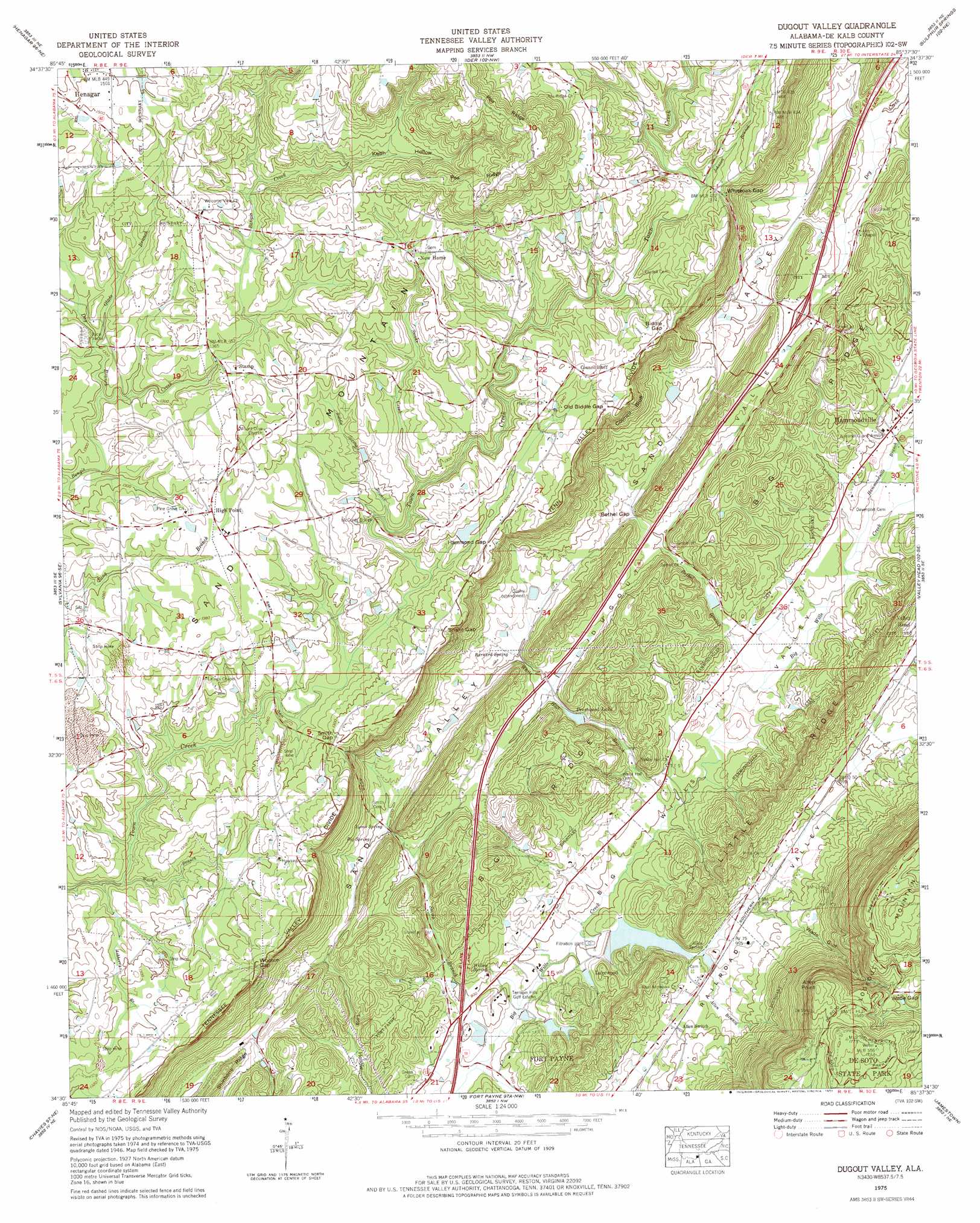
USGS Topo Quad 34085e6 - 1:24,000 scale
| Topo Map Name: | Dugout Valley |
| USGS Topo Quad ID: | 34085e6 |
| Print Size: | ca. 21 1/4" wide x 27" high |
| Southeast Coordinates: | 34.5° N latitude / 85.625° W longitude |
| Map Center Coordinates: | 34.5625° N latitude / 85.6875° W longitude |
| U.S. State: | AL |
| Filename: | o34085e6.jpg |
| Download Map JPG Image: | Dugout Valley topo map 1:24,000 scale |
| Map Type: | Topographic |
| Topo Series: | 7.5´ |
| Map Scale: | 1:24,000 |
| Source of Map Images: | United States Geological Survey (USGS) |
| Alternate Map Versions: |
Dugout Valley AL 1936 Download PDF Buy paper map Dugout Valley AL 1946, updated 1956 Download PDF Buy paper map Dugout Valley AL 1946, updated 1973 Download PDF Buy paper map Dugout Valley AL 1947, updated 1947 Download PDF Buy paper map Dugout Valley AL 1975, updated 1977 Download PDF Buy paper map Dugout Valley AL 2011 Download PDF Buy paper map Dugout Valley AL 2014 Download PDF Buy paper map |
1:24,000 Topo Quads surrounding Dugout Valley
Wannville |
Stevenson |
Flat Rock |
Trenton |
Durham |
Hollywood |
Henagar |
Ider |
Sulphur Springs |
Cedar Grove |
Dutton |
Sylvania |
Dugout Valley |
Valley Head |
Dougherty Gap |
Fyffe |
Chavies |
Fort Payne |
Jamestown |
Lyerly |
Crossville |
Portersville |
Little River |
Gaylesville |
Chattoogaville |
> Back to 34085e1 at 1:100,000 scale
> Back to 34084a1 at 1:250,000 scale
> Back to U.S. Topo Maps home
Dugout Valley topo map: Gazetteer
Dugout Valley: Bridges
McCurdy Bridge elevation 377m 1236′Dugout Valley: Capes
Allen Point elevation 529m 1735′Dugout Valley: Cliffs
Council Bluff elevation 400m 1312′Dugout Valley: Crossings
Interchange 231 elevation 329m 1079′Dugout Valley: Dams
Chambers Dam elevation 389m 1276′Fort Payne Dam elevation 277m 908′
Hawkins Dam elevation 296m 971′
Prestwood Dam elevation 289m 948′
Dugout Valley: Gaps
Bethel Gap elevation 308m 1010′Biddle Gap elevation 426m 1397′
Hammond Gap elevation 399m 1309′
Old Biddle Gap elevation 416m 1364′
Smith Gap elevation 388m 1272′
Snake Gap elevation 403m 1322′
Wade Gap elevation 466m 1528′
Wooten Gap elevation 413m 1354′
Dugout Valley: Populated Places
Cordell (historical) elevation 533m 1748′Council Bluff elevation 418m 1371′
Hammondville elevation 304m 997′
High Point elevation 415m 1361′
Lakewood elevation 290m 951′
Mays Gulf (historical) elevation 438m 1437′
New Home elevation 433m 1420′
Snake Creek (historical) elevation 422m 1384′
Stamp elevation 405m 1328′
Dugout Valley: Reservoirs
Chambers Lake elevation 389m 1276′Fort Payne City Lake elevation 283m 928′
Hawkins Lake elevation 296m 971′
Prestwood Lake elevation 292m 958′
Wills Lake elevation 289m 948′
Dugout Valley: Ridges
Pea Ridge elevation 514m 1686′Dugout Valley: Springs
Allen Spring elevation 287m 941′Barnard Spring elevation 308m 1010′
Big Spring elevation 305m 1000′
Lyons Spring elevation 303m 994′
Willow Spring elevation 268m 879′
Dugout Valley: Streams
Allen Branch elevation 273m 895′Ashberry Branch elevation 366m 1200′
Bethel Branch elevation 280m 918′
Biddle Spring Branch elevation 379m 1243′
Day Branch elevation 387m 1269′
Glade Branch elevation 396m 1299′
Hammondville Branch elevation 291m 954′
Johnson Branch elevation 401m 1315′
Keith Branch elevation 417m 1368′
Smith Branch elevation 268m 879′
Snake Creek elevation 382m 1253′
Thomas Branch elevation 298m 977′
Walker Branch elevation 370m 1213′
West Fork Bengis Creek elevation 382m 1253′
White Hall Branch elevation 273m 895′
Dugout Valley: Valleys
Keith Hollow elevation 414m 1358′Wade Gulf elevation 296m 971′
Dugout Valley digital topo map on disk
Buy this Dugout Valley topo map showing relief, roads, GPS coordinates and other geographical features, as a high-resolution digital map file on DVD: