Sylvania Topo Map Alabama
To zoom in, hover over the map of Sylvania
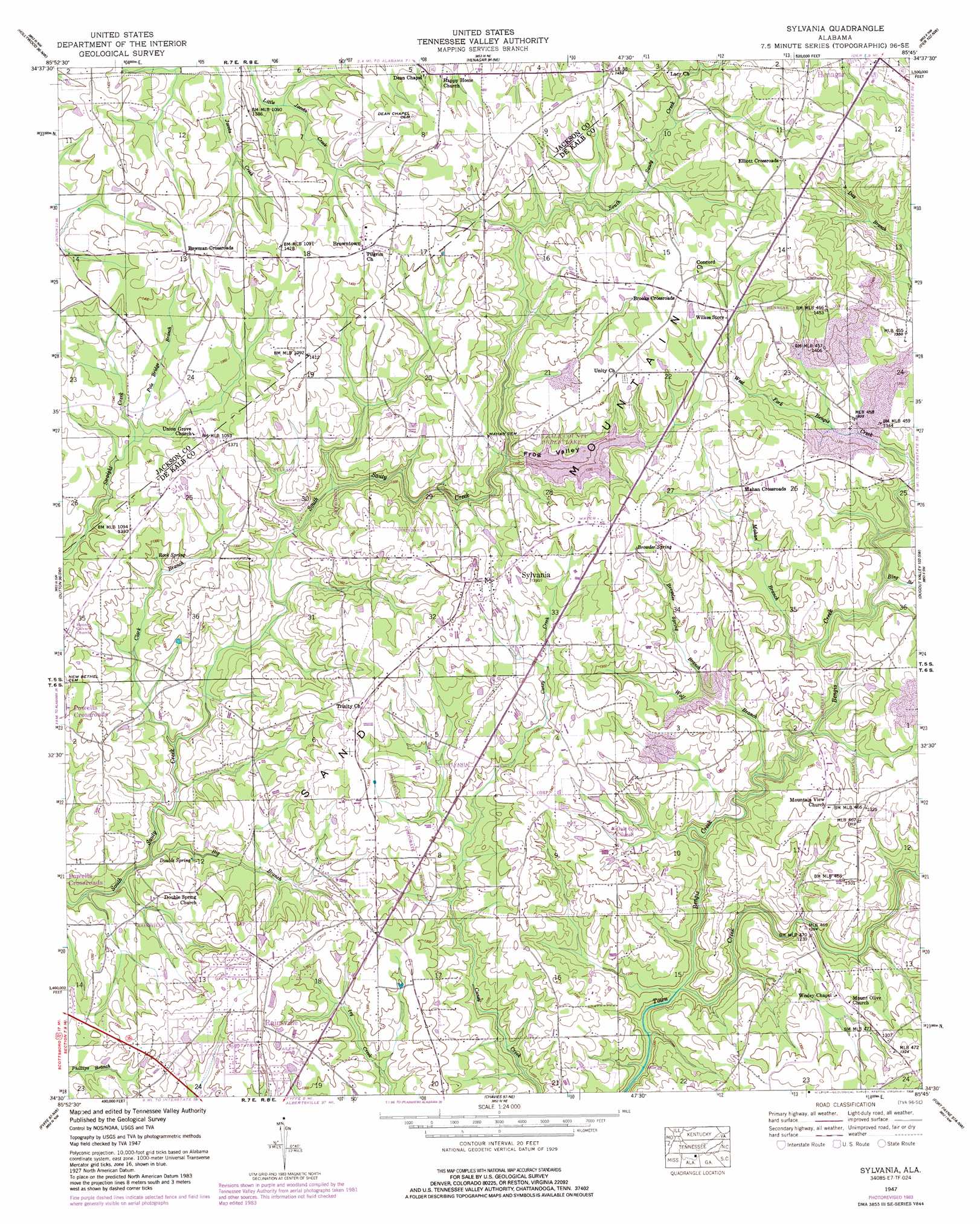
USGS Topo Quad 34085e7 - 1:24,000 scale
| Topo Map Name: | Sylvania |
| USGS Topo Quad ID: | 34085e7 |
| Print Size: | ca. 21 1/4" wide x 27" high |
| Southeast Coordinates: | 34.5° N latitude / 85.75° W longitude |
| Map Center Coordinates: | 34.5625° N latitude / 85.8125° W longitude |
| U.S. State: | AL |
| Filename: | o34085e7.jpg |
| Download Map JPG Image: | Sylvania topo map 1:24,000 scale |
| Map Type: | Topographic |
| Topo Series: | 7.5´ |
| Map Scale: | 1:24,000 |
| Source of Map Images: | United States Geological Survey (USGS) |
| Alternate Map Versions: |
Sylvania AL 1936 Download PDF Buy paper map Sylvania AL 1947, updated 1976 Download PDF Buy paper map Sylvania AL 1947, updated 1984 Download PDF Buy paper map Sylvania AL 1947, updated 1984 Download PDF Buy paper map Sylvania AL 1950 Download PDF Buy paper map Sylvania AL 2011 Download PDF Buy paper map Sylvania AL 2014 Download PDF Buy paper map |
1:24,000 Topo Quads surrounding Sylvania
Mud Creek |
Wannville |
Stevenson |
Flat Rock |
Trenton |
Scottsboro |
Hollywood |
Henagar |
Ider |
Sulphur Springs |
Langston |
Dutton |
Sylvania |
Dugout Valley |
Valley Head |
Grove Oak |
Fyffe |
Chavies |
Fort Payne |
Jamestown |
Painter |
Crossville |
Portersville |
Little River |
Gaylesville |
> Back to 34085e1 at 1:100,000 scale
> Back to 34084a1 at 1:250,000 scale
> Back to U.S. Topo Maps home
Sylvania topo map: Gazetteer
Sylvania: Areas
Sand Mountain elevation 388m 1272′Sylvania: Dams
Dekalb County Public Lake Dam elevation 405m 1328′Sylvania: Populated Places
Blake elevation 400m 1312′Bowman Crossroads elevation 439m 1440′
Brooks Crossroads elevation 436m 1430′
Browntown elevation 433m 1420′
Elliott Crossroads elevation 449m 1473′
Mahan (historical) elevation 400m 1312′
Mahan Crossroads elevation 413m 1354′
Musgrove (historical) elevation 396m 1299′
Sylvania elevation 423m 1387′
Sylvania: Post Offices
Sylvania Post Office elevation 432m 1417′Sylvania: Reservoirs
DeKalb County Public Lake elevation 390m 1279′Sylvania: Springs
Browder Spring elevation 428m 1404′Double Spring elevation 372m 1220′
Rock Spring elevation 389m 1276′
Sylvania: Streams
Bengis Creek elevation 357m 1171′Big Branch elevation 359m 1177′
Bing Branch elevation 378m 1240′
Browder Spring Branch elevation 383m 1256′
Clark Branch elevation 364m 1194′
Mahan Branch elevation 376m 1233′
Pole Bridge Branch elevation 398m 1305′
Wolf Branch elevation 370m 1213′
Sylvania: Valleys
Frog Valley elevation 390m 1279′Sylvania digital topo map on disk
Buy this Sylvania topo map showing relief, roads, GPS coordinates and other geographical features, as a high-resolution digital map file on DVD: