Dutton Topo Map Alabama
To zoom in, hover over the map of Dutton
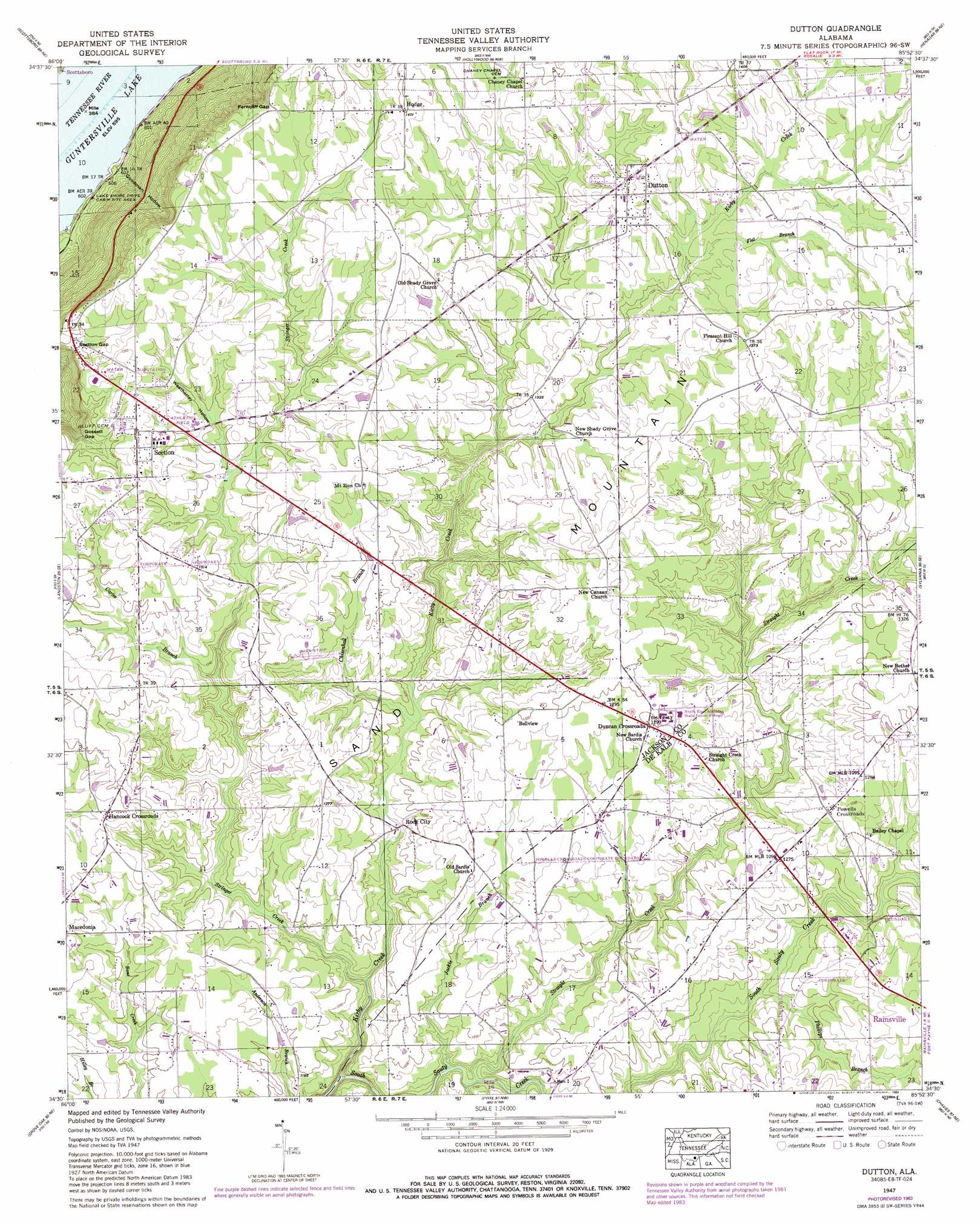
USGS Topo Quad 34085e8 - 1:24,000 scale
| Topo Map Name: | Dutton |
| USGS Topo Quad ID: | 34085e8 |
| Print Size: | ca. 21 1/4" wide x 27" high |
| Southeast Coordinates: | 34.5° N latitude / 85.875° W longitude |
| Map Center Coordinates: | 34.5625° N latitude / 85.9375° W longitude |
| U.S. State: | AL |
| Filename: | o34085e8.jpg |
| Download Map JPG Image: | Dutton topo map 1:24,000 scale |
| Map Type: | Topographic |
| Topo Series: | 7.5´ |
| Map Scale: | 1:24,000 |
| Source of Map Images: | United States Geological Survey (USGS) |
| Alternate Map Versions: |
Dutton AL 1936 Download PDF Buy paper map Dutton AL 1947, updated 1972 Download PDF Buy paper map Dutton AL 1947, updated 1984 Download PDF Buy paper map Dutton AL 1950 Download PDF Buy paper map Dutton AL 2011 Download PDF Buy paper map Dutton AL 2014 Download PDF Buy paper map |
1:24,000 Topo Quads surrounding Dutton
Princeton |
Mud Creek |
Wannville |
Stevenson |
Flat Rock |
Lim Rock |
Scottsboro |
Hollywood |
Henagar |
Ider |
Swearengin |
Langston |
Dutton |
Sylvania |
Dugout Valley |
Columbus City |
Grove Oak |
Fyffe |
Chavies |
Fort Payne |
Albertville |
Painter |
Crossville |
Portersville |
Little River |
> Back to 34085e1 at 1:100,000 scale
> Back to 34084a1 at 1:250,000 scale
> Back to U.S. Topo Maps home
Dutton topo map: Gazetteer
Dutton: Bars
Chisenhall Bar elevation 181m 593′Dutton: Gaps
Ferncliff Gap elevation 416m 1364′Gossett Gap elevation 380m 1246′
Section Gap elevation 392m 1286′
Dutton: Populated Places
Bellview elevation 395m 1295′Duncan Crossroads elevation 396m 1299′
Dutton elevation 416m 1364′
Ferncliff (historical) elevation 415m 1361′
Hancock Crossroads elevation 391m 1282′
Hannah (historical) elevation 383m 1256′
Hodge elevation 427m 1400′
Powells Crossroads elevation 389m 1276′
Rock City elevation 357m 1171′
Section elevation 409m 1341′
Talley (historical) elevation 377m 1236′
Dutton: Streams
Carter Branch elevation 359m 1177′Chisenhall Branch elevation 356m 1167′
Flat Branch elevation 396m 1299′
Jackie Branch elevation 337m 1105′
Kirby Creek elevation 322m 1056′
Phillips Branch elevation 347m 1138′
Straight Creek elevation 342m 1122′
Stringer Creek elevation 344m 1128′
Weatherley Branch elevation 385m 1263′
Dutton: Valleys
Goodman Hollow elevation 183m 600′Weatherley Hollow elevation 391m 1282′
Dutton digital topo map on disk
Buy this Dutton topo map showing relief, roads, GPS coordinates and other geographical features, as a high-resolution digital map file on DVD: