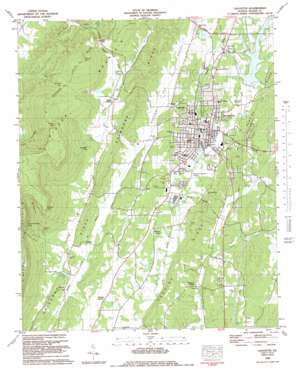
Estelle Topo Map Georgia
To zoom in, hover over the map of Estelle
USGS Topo Quad 34085f3 - 1:24,000 scale
| Topo Map Name: | Estelle |
| USGS Topo Quad ID: | 34085f3 |
| Print Size: | ca. 21 1/4" wide x 27" high |
| Southeast Coordinates: | 34.625° N latitude / 85.25° W longitude |
| Map Center Coordinates: | 34.6875° N latitude / 85.3125° W longitude |
| U.S. State: | GA |
| Filename: | o34085f3.jpg |
| Download Map JPG Image: | Estelle topo map 1:24,000 scale |
| Map Type: | Topographic |
| Topo Series: | 7.5´ |
| Map Scale: | 1:24,000 |
| Source of Map Images: | United States Geological Survey (USGS) |
| Alternate Map Versions: |
Estelle GA 1936 Download PDF Buy paper map Estelle GA 1946, updated 1960 Download PDF Buy paper map Estelle GA 1946, updated 1967 Download PDF Buy paper map Estelle GA 1946, updated 1975 Download PDF Buy paper map Estelle GA 1947, updated 1948 Download PDF Buy paper map Lafayette GA 1983, updated 1983 Download PDF Buy paper map LaFayette GA 2011 Download PDF Buy paper map LaFayette GA 2014 Download PDF Buy paper map |
1:24,000 Topo Quads surrounding Estelle
> Back to 34085e1 at 1:100,000 scale
> Back to 34084a1 at 1:250,000 scale
> Back to U.S. Topo Maps home
Estelle topo map: Gazetteer
Estelle: Airports
Barwick Lafayette Airport elevation 230m 754′Estelle: Basins
Cornfield Sink elevation 288m 944′The Pocket elevation 423m 1387′
Estelle: Capes
Atwood Point elevation 566m 1856′Estelle: Cliffs
Flatrock Point elevation 521m 1709′Estelle: Dams
Gordon Lake Dam elevation 270m 885′Towncreek Watershed Structure Number One Dam elevation 248m 813′
Estelle: Gaps
Bluebird Gap elevation 384m 1259′Dug Gap elevation 334m 1095′
Estelle: Lakes
Wilson Ponds elevation 238m 780′Estelle: Mines
Walker County Quarry elevation 260m 853′Estelle: Parks
Lowell Green Recreation Area elevation 262m 859′Estelle: Populated Places
Blaylock Mill elevation 228m 748′Bronco elevation 231m 757′
Dogwood Circle elevation 256m 839′
Estelle elevation 261m 856′
Fairview Heights elevation 263m 862′
Guild (historical) elevation 233m 764′
Horse Lake Estates elevation 280m 918′
LaFayette elevation 247m 810′
Linwood elevation 248m 813′
Marsh Crossing elevation 261m 856′
Meadowview elevation 273m 895′
Mount Carmel elevation 248m 813′
Oak Park elevation 242m 793′
Pledger Parkway elevation 240m 787′
Skyline Heights elevation 329m 1079′
Valley Head elevation 327m 1072′
Walnut Grove elevation 262m 859′
Winwood Forest elevation 281m 921′
Estelle: Post Offices
LaFayette Post Office elevation 245m 803′Estelle: Reservoirs
Blaylock Mill Pond elevation 238m 780′Chandler Lake elevation 232m 761′
Dickson Lake elevation 236m 774′
Gordon Lake elevation 270m 885′
LaFayette City Reservoir elevation 248m 813′
Lafayette Water Supply Lake elevation 248m 813′
Estelle: Springs
Big Spring elevation 252m 826′Buzzard Roost Spring elevation 242m 793′
Coffman Spring elevation 253m 830′
Dickson Spring elevation 243m 797′
Estelle: Streams
Arnold Branch elevation 248m 813′Dickson Creek elevation 225m 738′
Dry Creek elevation 225m 738′
Dry Creek elevation 241m 790′
Possumtrot Branch elevation 246m 807′
Rocky Branch elevation 232m 761′
Stanfield Branch elevation 248m 813′
Town Creek elevation 234m 767′
Walden Branch elevation 273m 895′
Waterfall Branch elevation 242m 793′
Estelle: Trails
LaFayette Jogging Trail elevation 250m 820′Estelle: Valleys
Burnt Mill Valley elevation 260m 853′Devils Cove elevation 267m 875′
Dickson Gulf elevation 261m 856′
McWhorter Gulf elevation 293m 961′
Straight Gut Valley elevation 243m 797′
Estelle digital topo map on disk
Buy this Estelle topo map showing relief, roads, GPS coordinates and other geographical features, as a high-resolution digital map file on DVD:


