Hollywood Topo Map Alabama
To zoom in, hover over the map of Hollywood
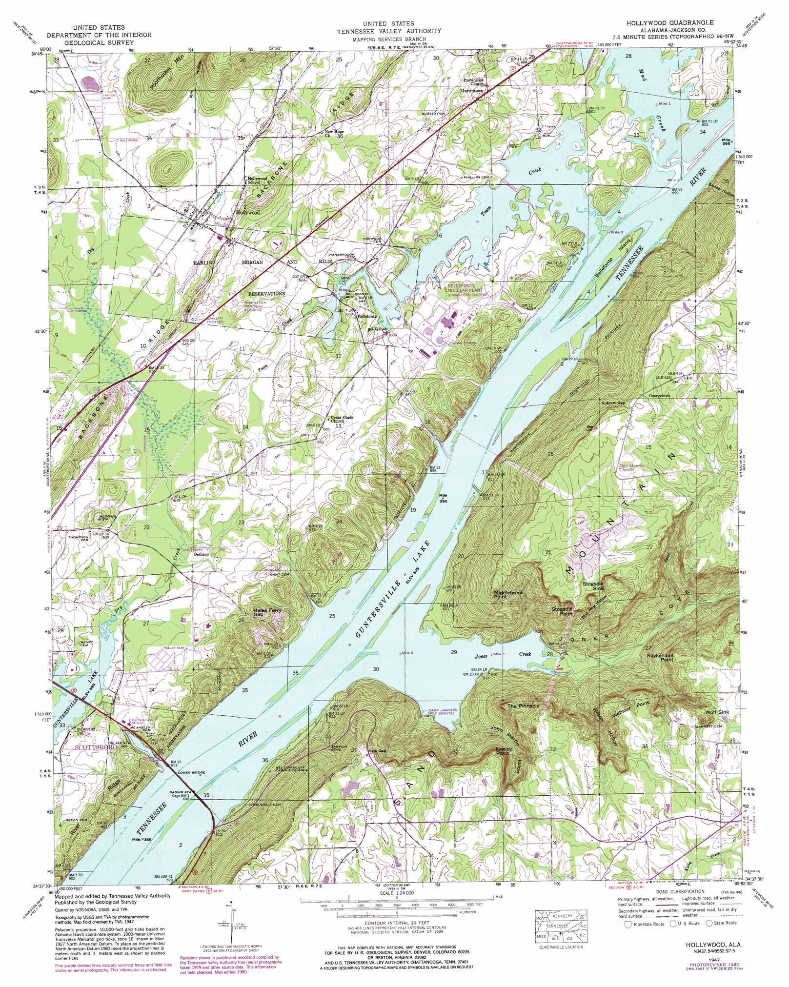
USGS Topo Quad 34085f8 - 1:24,000 scale
| Topo Map Name: | Hollywood |
| USGS Topo Quad ID: | 34085f8 |
| Print Size: | ca. 21 1/4" wide x 27" high |
| Southeast Coordinates: | 34.625° N latitude / 85.875° W longitude |
| Map Center Coordinates: | 34.6875° N latitude / 85.9375° W longitude |
| U.S. State: | AL |
| Filename: | o34085f8.jpg |
| Download Map JPG Image: | Hollywood topo map 1:24,000 scale |
| Map Type: | Topographic |
| Topo Series: | 7.5´ |
| Map Scale: | 1:24,000 |
| Source of Map Images: | United States Geological Survey (USGS) |
| Alternate Map Versions: |
Hollywood AL 1936 Download PDF Buy paper map Hollywood AL 1947, updated 1972 Download PDF Buy paper map Hollywood AL 1947, updated 1974 Download PDF Buy paper map Hollywood AL 1947, updated 1981 Download PDF Buy paper map Hollywood AL 1947, updated 1981 Download PDF Buy paper map Hollywood AL 1950 Download PDF Buy paper map Hollywood AL 2011 Download PDF Buy paper map Hollywood AL 2014 Download PDF Buy paper map |
1:24,000 Topo Quads surrounding Hollywood
Estill Fork |
Hytop |
Eureka |
Doran Cove |
Bridgeport |
Princeton |
Mud Creek |
Wannville |
Stevenson |
Flat Rock |
Lim Rock |
Scottsboro |
Hollywood |
Henagar |
Ider |
Swearengin |
Langston |
Dutton |
Sylvania |
Dugout Valley |
Columbus City |
Grove Oak |
Fyffe |
Chavies |
Fort Payne |
> Back to 34085e1 at 1:100,000 scale
> Back to 34084a1 at 1:250,000 scale
> Back to U.S. Topo Maps home
Hollywood topo map: Gazetteer
Hollywood: Bars
Bellefonte Bar elevation 181m 593′Jones Bar elevation 181m 593′
Hollywood: Basins
Stogsdill Sink elevation 346m 1135′Wolf Sink elevation 386m 1266′
Hollywood: Bends
Sartain Bend elevation 255m 836′Hollywood: Bridges
Comer Bridge elevation 181m 593′Hollywood: Capes
Kuykendall Point elevation 399m 1309′Middlebrook Point elevation 418m 1371′
Neeley Point elevation 405m 1328′
Stogsdill Point elevation 406m 1332′
Webster Point elevation 409m 1341′
Hollywood: Crossings
Hales Ferry (historical) elevation 181m 593′McGuinns Ferry (historical) elevation 181m 593′
Snodgrass Ferry (historical) elevation 182m 597′
Starke Ferry (historical) elevation 181m 593′
Sublett Ferry (historical) elevation 181m 593′
Whites Ferry (historical) elevation 181m 593′
Hollywood: Dams
Waites Dam elevation 400m 1312′Hollywood: Gaps
Hale Gap elevation 398m 1305′Hales Ferry Gap elevation 223m 731′
Sublett Gap elevation 422m 1384′
Hollywood: Islands
Bellefonte Island elevation 182m 597′Hollywood: Mines
Wheeler Mine elevation 213m 698′Hollywood: Parks
Harlin Morgan and Rilie Reservations elevation 187m 613′McNary Reservation elevation 186m 610′
Hollywood: Pillars
The Pinnacle elevation 389m 1276′Hollywood: Populated Places
Bellefonte elevation 197m 646′Georgetown elevation 420m 1377′
Gray (historical) elevation 219m 718′
Hollywood elevation 193m 633′
Index (historical) elevation 427m 1400′
Martintown elevation 216m 708′
Nacoochee Point Subdivision elevation 187m 613′
Riverland Estates elevation 182m 597′
Rorex (historical) elevation 393m 1289′
Sam Gant Subdivision elevation 201m 659′
Hollywood: Reservoirs
Clarks Lake (historical) elevation 181m 593′Waites Lake elevation 400m 1312′
Hollywood: Ridges
Backbone Ridge elevation 232m 761′Hollywood: Streams
Jones Creek elevation 181m 593′Mud Creek elevation 181m 593′
Rorex Creek elevation 200m 656′
Town Creek elevation 182m 597′
Hollywood: Valleys
Bishop Hollow elevation 182m 597′John Martin Hollow elevation 181m 593′
Jones Cove elevation 181m 593′
Mill Hollow elevation 204m 669′
Wild Hog Hollow elevation 289m 948′
Wilson Hollow elevation 188m 616′
Hollywood digital topo map on disk
Buy this Hollywood topo map showing relief, roads, GPS coordinates and other geographical features, as a high-resolution digital map file on DVD: