Nickajack Gap Topo Map Georgia
To zoom in, hover over the map of Nickajack Gap
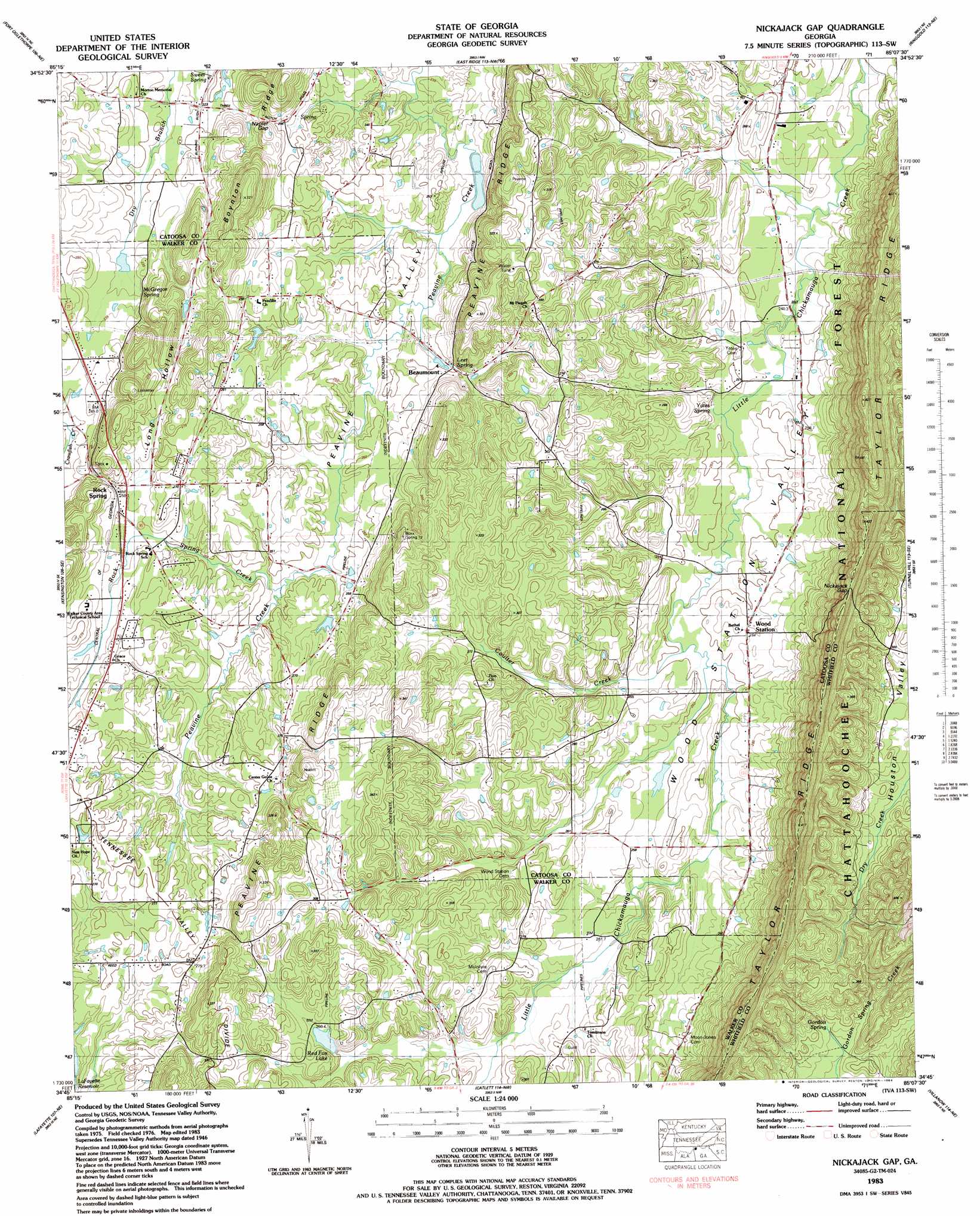
USGS Topo Quad 34085g2 - 1:24,000 scale
| Topo Map Name: | Nickajack Gap |
| USGS Topo Quad ID: | 34085g2 |
| Print Size: | ca. 21 1/4" wide x 27" high |
| Southeast Coordinates: | 34.75° N latitude / 85.125° W longitude |
| Map Center Coordinates: | 34.8125° N latitude / 85.1875° W longitude |
| U.S. State: | GA |
| Filename: | o34085g2.jpg |
| Download Map JPG Image: | Nickajack Gap topo map 1:24,000 scale |
| Map Type: | Topographic |
| Topo Series: | 7.5´ |
| Map Scale: | 1:24,000 |
| Source of Map Images: | United States Geological Survey (USGS) |
| Alternate Map Versions: |
Nickajack Gap GA 1935 Download PDF Buy paper map Nickajack Gap GA 1946, updated 1947 Download PDF Buy paper map Nickajack Gap GA 1946, updated 1960 Download PDF Buy paper map Nickajack Gap GA 1946, updated 1966 Download PDF Buy paper map Nickajack Gap GA 1946, updated 1972 Download PDF Buy paper map Nickajack Gap GA 1983, updated 1984 Download PDF Buy paper map Nickajack Gap GA 2011 Download PDF Buy paper map Nickajack Gap GA 2014 Download PDF Buy paper map |
| FStopo: | US Forest Service topo Nickajack Gap is available: Download FStopo PDF Download FStopo TIF |
1:24,000 Topo Quads surrounding Nickajack Gap
Wauhatchie |
Chattanooga |
East Chattanooga |
Ooltewah |
Mcdonald |
Hooker |
Fort Oglethorpe |
East Ridge |
Ringgold |
Cohutta |
Durham |
Kensington |
Nickajack Gap |
Tunnel Hill |
Dalton North |
Cedar Grove |
Estelle |
Catlett |
Villanow |
Dalton South |
Dougherty Gap |
Trion |
Subligna |
Sugar Valley |
Calhoun North |
> Back to 34085e1 at 1:100,000 scale
> Back to 34084a1 at 1:250,000 scale
> Back to U.S. Topo Maps home
Nickajack Gap topo map: Gazetteer
Nickajack Gap: Dams
Howard Lake Dam elevation 255m 836′Jackson Lake Dam elevation 233m 764′
Red Fox Lake Dam elevation 277m 908′
Williams Lake Dam elevation 277m 908′
Nickajack Gap: Gaps
Napier Gap elevation 253m 830′Nickajack Gap elevation 394m 1292′
Nickajack Gap: Parks
Houston Valley ORV Area elevation 358m 1174′Nickajack Gap: Populated Places
Beaumount elevation 248m 813′Center Grove elevation 279m 915′
Freetown (historical) elevation 255m 836′
Gordon Springs (historical) elevation 290m 951′
Mount Pisgah elevation 295m 967′
Rock Spring elevation 259m 849′
Nickajack Gap: Post Offices
Rock Spring Post Office elevation 258m 846′Nickajack Gap: Reservoirs
Howard Lake elevation 255m 836′Jackson Lake elevation 233m 764′
Red Fox Lake elevation 277m 908′
Whaley Lake elevation 272m 892′
Williams Lake elevation 277m 908′
Nickajack Gap: Ridges
Peavine Ridge elevation 316m 1036′Nickajack Gap: Springs
Gordon Spring elevation 294m 964′Leet Spring elevation 249m 816′
McGregor Spring elevation 230m 754′
Yates Spring elevation 244m 800′
Nickajack Gap: Streams
Coulter Creek elevation 250m 820′Rock Spring Creek elevation 244m 800′
Nickajack Gap: Summits
Beaumont Mountain elevation 337m 1105′Belmont Mountain elevation 332m 1089′
Nickajack Gap: Valleys
Long Hollow elevation 258m 846′Wood Station Valley elevation 240m 787′
Nickajack Gap digital topo map on disk
Buy this Nickajack Gap topo map showing relief, roads, GPS coordinates and other geographical features, as a high-resolution digital map file on DVD: