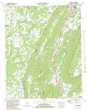
Trenton Topo Map Georgia
To zoom in, hover over the map of Trenton
USGS Topo Quad 34085g5 - 1:24,000 scale
| Topo Map Name: | Trenton |
| USGS Topo Quad ID: | 34085g5 |
| Print Size: | ca. 21 1/4" wide x 27" high |
| Southeast Coordinates: | 34.75° N latitude / 85.5° W longitude |
| Map Center Coordinates: | 34.8125° N latitude / 85.5625° W longitude |
| U.S. States: | GA, AL |
| Filename: | o34085g5.jpg |
| Download Map JPG Image: | Trenton topo map 1:24,000 scale |
| Map Type: | Topographic |
| Topo Series: | 7.5´ |
| Map Scale: | 1:24,000 |
| Source of Map Images: | United States Geological Survey (USGS) |
| Alternate Map Versions: |
Trenton GA 1936 Download PDF Buy paper map Trenton GA 1946, updated 1947 Download PDF Buy paper map Trenton GA 1946, updated 1962 Download PDF Buy paper map Trenton GA 1946, updated 1967 Download PDF Buy paper map Trenton GA 1946, updated 1975 Download PDF Buy paper map Trenton GA 1982, updated 1984 Download PDF Buy paper map Trenton GA 2011 Download PDF Buy paper map Trenton GA 2014 Download PDF Buy paper map |
1:24,000 Topo Quads surrounding Trenton
> Back to 34085e1 at 1:100,000 scale
> Back to 34084a1 at 1:250,000 scale
> Back to U.S. Topo Maps home
Trenton topo map: Gazetteer
Trenton: Crossings
Exit One elevation 251m 823′Exit Two elevation 235m 770′
Trenton: Dams
McGee Lake Dam elevation 586m 1922′Vaught Lake Dam elevation 437m 1433′
Young Lake Dam elevation 263m 862′
Trenton: Flats
Well Flat elevation 308m 1010′Trenton: Gaps
Bee Gap elevation 601m 1971′Brown Gap elevation 460m 1509′
Cagle Gap elevation 504m 1653′
Easley Gap elevation 621m 2037′
Magby Gap elevation 434m 1423′
Payne Gap elevation 598m 1961′
Trenton: Mines
White Oak Mine elevation 464m 1522′Trenton: Populated Places
Beulah elevation 508m 1666′Cartersville elevation 508m 1666′
Cedar Hill elevation 249m 816′
Deer Head Cove elevation 322m 1056′
Eliza elevation 447m 1466′
Floral Crest elevation 460m 1509′
Gass elevation 477m 1564′
Higdon elevation 418m 1371′
Mount Olive elevation 432m 1417′
Rising Fawn elevation 244m 800′
Shiloh elevation 430m 1410′
Stewart Town elevation 255m 836′
Tatum (historical) elevation 232m 761′
Trenton elevation 230m 754′
Union elevation 233m 764′
Trenton: Post Offices
Rising Fawn Post Office elevation 244m 800′Trenton Post Office elevation 232m 761′
Trenton: Reservoirs
McGee Lake elevation 586m 1922′Moore Lake elevation 587m 1925′
Vaught Lake elevation 437m 1433′
Young Lake elevation 263m 862′
Trenton: Ridges
Pudding Ridge elevation 401m 1315′Pudding Ridge elevation 416m 1364′
Trenton: Springs
Poplar Spring elevation 342m 1122′Trenton: Streams
Allison Creek elevation 230m 754′Allison Creek elevation 231m 757′
Austin Creek elevation 430m 1410′
Back Valley elevation 254m 833′
Big Spring Branch elevation 422m 1384′
Bullard Branch elevation 419m 1374′
Bullard Branch elevation 418m 1371′
Crawfish Creek elevation 223m 731′
Crawfish Creek elevation 224m 734′
Crooked Branch elevation 411m 1348′
Duncan Creek elevation 413m 1354′
Harris Creek elevation 422m 1384′
Hurricane Creek elevation 235m 770′
Rocky Ford Branch elevation 425m 1394′
Sally Branch elevation 424m 1391′
Shiloh Creek elevation 415m 1361′
Stewart Town Creek elevation 246m 807′
Tadpole Branch elevation 221m 725′
Turner Branch elevation 219m 718′
Williams Spring Branch elevation 411m 1348′
Wooden Branch elevation 409m 1341′
Trenton: Valleys
Deer Head Cove elevation 234m 767′Stewart Gulch elevation 252m 826′
Trenton digital topo map on disk
Buy this Trenton topo map showing relief, roads, GPS coordinates and other geographical features, as a high-resolution digital map file on DVD:


